Hawaii residents hit by floods from Hurricane Lane as new storm forms

FILE PHOTO: Large waves crash against the shoreline on the east side of Oahu as Hurricane Lane approaches Honolulu, Hawaii, U.S. August 24, 2018. REUTERS/Hugh Gentry

By Dan Whitcomb

(Reuters) – Flash flood warnings were issued on Tuesday for the Hawaiian island of Kauai, with residents on the north coast told to evacuate and others left stranded by high water as the remnants of Hurricane Lane drenched the archipelago and a new storm brewed in the Pacific Ocean.

Hawaii was spared a direct hit from a major hurricane as Lane diminished to a tropical storm as it approached and then drifted west, further from land. But rain was still pounding the island chain, touching off flooding on Oahu and Kauai.

“It has been a steady rain since after Lane but I got up 2:30 a.m. (Hawaiian Standard Time) to the National Weather Service flash flood advisory and that’s when we put out the release as well as an island-wide telephone call,” County of Kauai spokesman Alden Alayvilla said.

The advisory urged residents near Hanalei Bridge on the north side of the island to evacuate their homes due to rising stream levels. A convoy that had been used to escort residents over roads damaged by historic floods in April between was shut down, leaving many cut off.

“Heavy pounding and hazardous conditions are being reported island-wide. Motorists are advised to drive with extreme caution. Updates will be given as more information is made available,” the Kauai Emergency Management Agency said.

A flash flood watch also remained in effect for Oahu, home to the state capital Honolulu and 70 percent of Hawaii’s 1.4 million residents.

Micco Godinez, who lives on the north side of Kauai, said he found the only road out of Hanalei, where he lives, barricaded by police vehicles when he tried to leave for work on Tuesday morning. He expected to be stranded for at least another day.

“I can’t get out at all,” Godinez said. “Our little community of Hanalei is isolated and then west of us is even more isolated,” he said.

Even as Hawaii residents sought to recover from Lane, they kept a watchful eye on Tropical Storm Miriam, spinning in the Pacific Ocean some 2,000 miles to the east and expected to become a hurricane by the time it approaches the islands.

“Miriam is supposed to go north and dissipate in the colder waters and drier air, so I’m not really worried about it,” Godinez said. “But it is hurricane season, and there’s another one behind that. You know what they say: Without rain you wouldn’t have rainbows.”

(Reporting by Dan Whitcomb; Editing by Lisa Shumaker)

Approaching hurricane sparks runs in Hawaii on plywood, water and gasoline

Paul Akamine fills propane tanks for customers as Hurricane Lane approaches Honolulu, Hawaii, U.S. August 22, 2018. REUTERS/Hugh Gentry

By Sue Horton

HANALEI, Hawaii (Reuters) – Micco Godinez, who rents out kayaks on the island of Kauai and loves surfing, said he was twice tempted to hit the waves on Wednesday but kept his focus on a more pressing concern – getting ready to board up his home for a major hurricane.

With forecasts calling for Hurricane Lane to strike or brush past Hawaii’s “Garden Isle” on Friday, Godinez, 66, has joined tens of thousands of others on Kauai, and across the state, in the rituals of disaster preparation.

A long line of cars wait as people fill up their vehicles with gasoline as Hurricane Lane approaches Kauai, Hawaii, U.S., August 22, 2018. REUTERS/ Sue Horton

A long line of cars wait as people fill up their vehicles with gasoline as Hurricane Lane approaches Kauai, Hawaii, U.S., August 22, 2018. REUTERS/ Sue Horton

Lane, wavering between Category 4 and Category 5 strength on the five-step Saffir-Simpson hurricane scale, churned toward the U.S. Pacific island state with sustained winds of up to 155 miles per hour (250 kph) on Wednesday, as authorities urged residents to stock up on water, food and medicines.

Across Hawaii, jittery residents lined up at hardware centers, gasoline stations and grocery stores. But nowhere was the sense of urgency perhaps more palpable than on Kauai, where torrential rains four months ago triggered widespread flooding that destroyed homes and washed out roads.

“Some people here were just wiped out in that flood. It rained 50 inches (127 cm) in 24 hours,” said Hanalei resident Charlie Cowden, who owns several surf shops on the island. “Now there is this.”

Many older residents recalled even greater devastation from the last Category 4 storm to pummel Hawaii, Hurricane Iniki, which made landfall on Kauai in September 1992, killing six people and leveling or damaging more than 14,000 dwellings.

Luke Yamanuha loads plywood into his truck as Hurricane Lane approaches Honolulu, Hawaii, U.S. August 22, 2018. REUTERS/Hugh Gentry

Luke Yamanuha loads plywood into his truck as Hurricane Lane approaches Honolulu, Hawaii, U.S. August 22, 2018. REUTERS/Hugh Gentry

‘SLIM PICKINGS’

Godinez, who lives two blocks from the ocean in the bayside town of Hanalei on Kauai’s north shore, said he spent part of his day shopping for lumber and a recharging device for his portable drill.

He described the mood in town as “pleasantly apprehensive” and said he even felt the familiar pang of one of his favorite pastimes. “Twice the surf was up, and twice I wanted to go surfing, but I had other things pressing on my mind.”

He recalled getting up early to drive to a Home Depot building-supply outlet before it opened at 6 a.m., only to find two dozen others already lined up ahead of him.

“There’s a run on plywood,” he said. “It was slim pickings when I was there.”

Pausing later after filling up jugs of water, Godinez said he and his wife would spend the rest of the day taking measurements and cutting plywood to fit over more than 18 windows on their two-story house.

“Measure twice, cut once, and away we go,” he said, adding they would wait until Thursday for the latest forecasts before deciding whether to go ahead with fastening the boards to the windows.

Since Hanalei is on the opposite side of Kauai from where the hurricane is most likely to come ashore, Godinez said he was less concerned about ocean storm surge than ferocious winds.

Godinez said he, his wife and two guests planned to “hunker down” in a first-floor laundry room at the height of the storm, should it make landfall by late Thursday or early on Friday.

With two small laundry windows sealed up and probably no electricity, except for battery-powered flashlights, “It’s going to be hot and dark,” he said.

(Reporting by Sue Horton; Additional reporting and writing by Steve Gorman in Los Angeles; Editing by Bill Tarrant and Peter Cooney)

Hurricane Lane threatens direct hit on Hawaii, churns toward Oahu

A photo taken from the International Space Station and moved on social media by astronaut Ricky Arnold shows Hurricane Lane in the early morning hours near Hawaii, U.S., August 22, 2018. Courtesy @astro_ricky/NASA/Handout via REUTERS

y Jolyn Rosa

HONOLULU (Reuters) – Hurricane Lane, threatening a direct hit as Hawaii’s worst storm in a quarter century, on Thursday churned toward Oahu, the island with the largest population, as schools, government offices, and business closed and residents stocked up on supplies.

Packing sustained winds of up to 130 miles per hour (215 km per hour), Lane could dump 10 to 20 inches (25-50 cm) of rain, triggering flash floods and landslides, the National Weather Service (NWS) said. More than 30 inches could fall in some places, it said.

“Preparations to protect life and property should be rushed to completion,” the NWS Central Pacific Hurricane Center in Honolulu said in an advisory.

As of early Thursday, Lane was centered about 210 miles (335 km) south-southwest of Kailua-Kona, a town on the west coast of the Big Island, the NWS said. It was classified as a powerful Category 4 storm on the five-step Saffir-Simpson scale of hurricane strength.

The NWS said the storm weakened slightly overnight but excessive rainfall would affect the Hawaiian islands into the weekend, “leading to significant and life-threatening flash flooding and landslides.”

More than a foot of rain has already fallen on part of the Big Island, the NWS said on Thursday morning.

The center also warned of “very large and damaging surf” along exposed west- and south-facing shorelines, likely leading to significant coastal erosion.

A hurricane warning was in effect for Oahu, Maui County, and Hawaii County. The islands of Kauai and Niihau remained on hurricane watch and could face similar conditions starting Friday morning.

Governor David Ige has urged residents to take the threat seriously and prepare for the worst by setting aside a 14-day supply of water, food, and medicines.

All public schools, University of Hawaii campuses and nonessential government offices on the islands of Oahu and Kauai will be closed for at least two days starting on Thursday, Ige said Wednesday.

The shelves of a downtown Honolulu Walmart were stripped of items ranging from canned tuna to dog food as well as bottled water and coolers full of ice after warnings of possible power outages.

“I went to Safeway last night for regular groceries. Everyone was in a panic,” said Thao Nguyen, 35, an employee at a Honolulu branch of Hawaiian shirt retailer Roberta Oaks.

Long lines of cars formed at gasoline stations in Honolulu and people pulled small boats from the water ahead of the expected storm surge. U.S. Navy ships and submarines based in Hawaii were instructed to leave port, a common practice when a hurricane approaches to avoid damage.

President Donald Trump declared a state of emergency for Hawaii and ordered federal authorities to help supplement state and local responses, the White House said on Thursday.

The most powerful hurricane on record to hit Hawaii was Category 4 Iniki, which made landfall on Kauai island on Sept. 11, 1992, according to the National Oceanic and Atmospheric Administration. It killed six people and damaged or destroyed more than 14,000 homes.

(Additional reporting by Gina Cherelus in New York, Brendan O’Brien in Milwaukee, Doina Chiacu in Washington, and Steve Gorman and Dan Whitcomb in Los Angeles; Editing by Jeffrey Benkoe and Marguerita Choy)

Hurricane Lane strengthens to Category 5 as it heads for Hawaii

Members of the Alapahoe outrigger canoe club move their canoes off the beach to higher ground as Hurricane Lane approaches Honolulu, Hawaii, U.S. August 21, 2018. REUTERS/Hugh Gentry

By Jolyn Rosa

HONOLULU (Reuters) – Hurricane Lane strengthened to a Category 5 storm on Tuesday as it charged toward Hawaii where residents braced for “life threatening” winds and flooding, the National Hurricane Center (NHC) said.

Forecasters said it was still uncertain whether the eye of the powerful hurricane would hit land in the U.S. island chain, whose Big Island is reeling from a three-month eruption of Kilauea volcano.

But “preparations to protect life and property should be rushed to completion,” the center said.

The center of the storm is expected to track “dangerously” close to or over the islands Thursday through Saturday, the NHC said.

Jaycee Sotello fills her truck up with gas as Hurricane Lane approaches Honolulu, Hawaii, U.S. August 21, 2018. REUTERS/Hugh Gentry

Jaycee Sotello fills her truck up with gas as Hurricane Lane approaches Honolulu, Hawaii, U.S. August 21, 2018. REUTERS/Hugh Gentry

A direct hit anywhere in Hawaii “would be a worst-case scenario,” said Thomas Birchard, a meteorologist with the hurricane center.

The powerful hurricane was about 350 miles (565 km) south-southeast of Kailua-Kona, Hawaii, with maximum sustained winds of 160 miles per hour (260 km/h) at about 11:30 p.m. local time, the NHC said.

As of late Tuesday night, a hurricane warning was in effect for the Big Island and a hurricane watch was in effect for the rest of the state, the hurricane center said.

The storm, which was moving west-northwest near 9 mph (15 km/h), was expected to turn toward the northwest on Wednesday, followed by a turn to the north-northwest on Thursday, the center said.

Winds and rain from the storm are expected to hit the Big Island, then churn north over the islands of Maui, Lanai, and Moloka’i, which were all under hurricane and flash flood watches.

Rainfall of 20 inches (51 cm) in some areas could lead to major flash flooding, landslides, and mudslides, the NHC said.

Devastation caused by winds and flooding may make locations uninhabitable for weeks and Hawaii residents to be prepared to evacuate their homes, local authorities warned.

(Reporting by Andrew Hay and Brendan O’Brien; Editing by Bill Tarrant, Sandra Maler, and Andrew Heavens)

Unlikely pair could usher ‘right to carry’ gun law case to U.S. Supreme Court

George Young holds a framed photo of his late daughter Tim Young in Hilo, Hawaii, U.S., July 30, 2018. Picture taken July 30, 2018. Courtesy Lynn Viale/Handout via REUTERS

By Daniel Trotta

(Reuters) – George Young is a Vietnam War veteran who sued the state of Hawaii three times on his own without a lawyer for the right to carry a handgun and lost each time.

Alan Beck is an independent lawyer who took on Young’s appeal for free.

Last month, the duo won a major victory for gun rights when an appeals court found Hawaii’s restrictive handgun law unconstitutional, a ruling that could lead to a landmark decision from the U.S. Supreme Court on the right to bear arms in public. And they did so without the help of the powerful National Rifle Association (NRA) gun lobby.

“I went around the state of Hawaii and contacted about 17 attorneys and all of them turned me down. They said I would only lose,” said Young, 68. “I want to see it through to the end, which is the U.S. Supreme Court.”

U.S gun-control advocates favor strict laws like Hawaii’s, blaming lax gun laws for excessive gun violence and deadly mass shootings in the United States. The NRA and other gun-rights advocates oppose laws that restrict the constitutional right to bear arms and want the high court to take up a new case, hoping it will expand gun rights outside the home.

The Supreme Court has not taken on a major gun-rights case since a pair of cases in 2008 and 2010 in which the court established that the U.S. Constitution’s Second Amendment protects an individual’s right to keep a gun at home.

Hawaii allows only people who work in security or who can demonstrate to law enforcement officials that they have an “exceptional case” to carry weapons, concealed or openly.

After he left the Army, Young carried a firearm for 17 years as an airport security guard but lost that right after he retired. He failed to convince the County of Hawaii’s police chief he deserved a permit, so he sued, saying his constitutional right to bear arms was violated.

He filed suits in 2008, 2010 and 2012 to challenge the denials, losing each time.

Lacking the means to hire a lawyer for an appeal, Young would normally have had to depend on a star litigator financed by the NRA or a major law firm to take the case pro bono, or free of cost.

Instead Young paired up with Beck, a solo practitioner who learned of Young’s story and offered to represent him for free.

Beck said he has limited means of his own and that his father has offered to lend him money if needed to keep the case going.

“This covers my pro bono hours for my career. It’s worth it. Sometimes you have to do the right thing,” Beck said.

NO NRA HELP

Based in California but with family ties in Hawaii, Beck said he took Young’s case because he disagreed with the ruling by the U.S. District Court and said Young was denied the leeway that should be afforded to a non-lawyer representing himself.

“I didn’t think he got a fair shake,” Beck said. “We got to know each other very well. I know his family now. I consider him a good friend as well as a client.”

The NRA turned down a request to help with the case, Beck said, declining to elaborate. The NRA was still involved in assisting another lawsuit challenging carry laws when Young filed his suit, which is why the association did not get involved, spokeswoman Amy Hunter said.

On July 24, Young scored his first victory. In a 2-1 ruling, a three-judge panel of the normally liberal 9th U.S. Circuit Court of Appeals found Young has a Second Amendment right to carry a firearm in public. The NRA applauded the ruling.

Hawaii has until Sept. 14 to ask the case to be reheard by the same panel or “en banc” by a larger number of judges.

The state has defended its law by citing the 2008 and 2010 Supreme Court cases, District of Colombia v. Heller and McDonald v. City of Chicago. While those rulings were taken as a victory by gun-rights advocates, proponents of gun control say the court also established limits to the Second Amendment.

“Heller was not intended to extend the protections found in the Second Amendment to any area outside the home,” Hawaii said in a 2013 filing in the case.

‘CIRCUIT SPLIT’Some U.S. appeals courts have upheld state laws that greatly restrict gun carry rights while others have struck them down, creating what is known as “circuit split.” The Supreme Court often hears cases in order to resolve such splits, but it requires four out of nine Supreme Court justices to agree to hear a case.

“As a practical matter, there is indeed a circuit split,” said Eugene Volokh, a UCLA law professor.

George Young and his late daughter Tim Young in Hilo, Hawaii, U.S., in May 2006. Picture taken in May 2006. Courtesy George M. Young/Handout via REUTERS

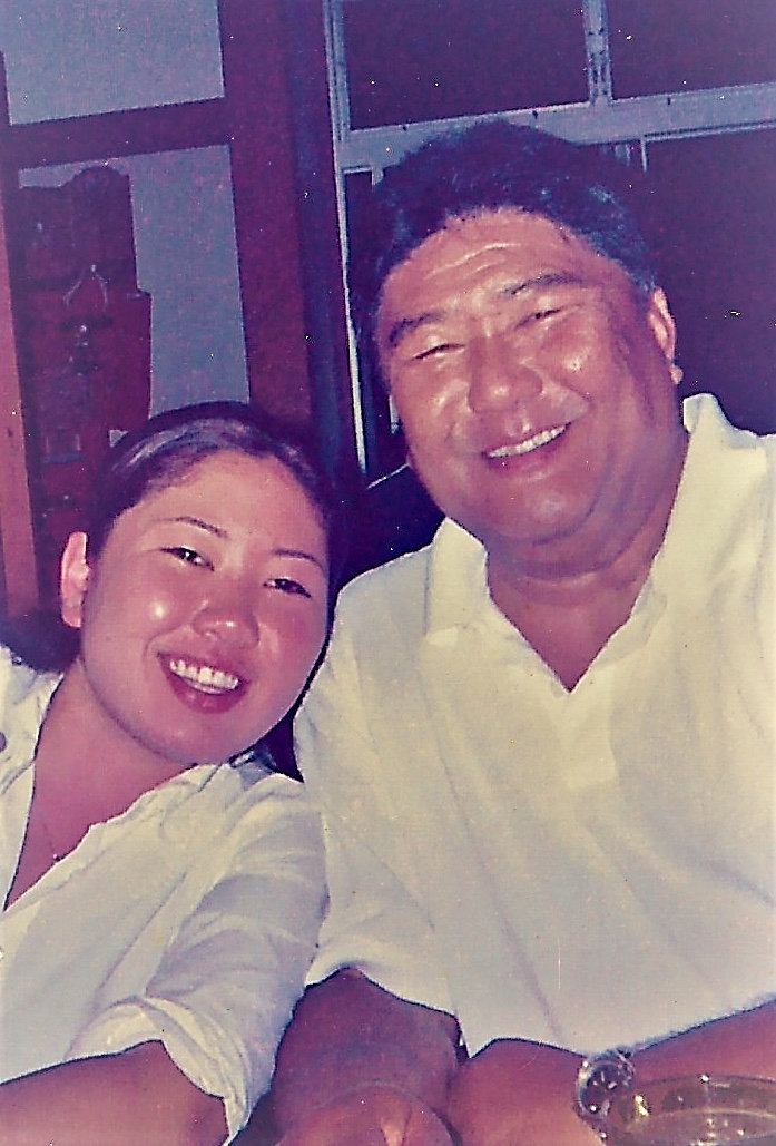
George Young and his late daughter Tim Young in Hilo, Hawaii, U.S., in May 2006. Picture was taken in May 2006. Courtesy George M. Young/Handout via REUTERS

Young, who is part native Hawaiian and part descendant of Japanese plantation workers, became passionate about the issue while teaching his late daughter Tim, who died in a car accident in 2004 at age 21, about the Constitution.

“She was my pet. Of my three children she was the one to follow me everywhere,” Young said.

One day, as they discussed the Constitution, Young was startled when she told him he could not carry a handgun in Hawaii, so he began his quest.

“I made the promise that they cannot take your Second Amendment away,” Young said. “So to prove it to her, that’s when I started.”

(Reporting by Daniel Trotta; Editing by Dina Kyriakidou and Frances Kerry)

Hawaii eruption could last years, destroy new areas: geologists

FILE PHOTO: Lava erupts in Leilani Estates during ongoing eruptions of the Kilauea Volcano in Hawaii, U.S., June 5, 2018. REUTERS/Terray Sylvester/File Photo

(Reuters) – The eruption of Hawaii’s Kilauea volcano could last for months or years and threaten new communities on the Big Island, according to a report by U.S. government geologists.

A main risk is a possible change in the direction of a lava flow that would destroy more residential areas after at least 712 homes were torched and thousands of residents forced to evacuate since Kilauea began erupting on May 3, the report by the Hawaiian Volcano Observatory said.

A higher volume of molten rock is flowing underground from Kilauea’s summit lava reservoir than in previous eruptions, with supply to a single giant crack — fissure 8 — showing no sign of waning, according to the study published last week.

“If the ongoing eruption maintains its current style of activity at a high eruption rate, then it may take months to a year or two to wind down,” said the report designed to help authorities on the Big Island deal with potential risks from the volcano.

Lava is bursting from same area about 25 miles (40 km) down Kilauea’s eastern side as it did in eruptions of 1840, 1955 and 1960, the report said. The longest of those eruptions was in 1955. It lasted 88 days, separated by pauses in activity.

The current eruption could become the longest in the volcano’s recorded history, it added.

Geologists believe previous eruptions may have stopped as underground lava pressure dropped due to multiple fissures opening up in this Lower East Rift Zone, the report said.

The current eruption has coalesced around a single fissure, allowing lava pressure to remain high.

A 1,300-foot-wide (400-meter) lava river now flows to the ocean from this “source cone” through an elevated channel about 52 to 72 feet (16 to 22 meters) above ground.

“The main hazard from the source cone and the channel system is a failure of the cone or channel walls, or blockage of the channel where it divides in narrower braids. Either could divert most, if not all, of the lava to a new course depending on where the breach occurs,” the report said.

The report said it only considered risks from a change in lava flow direction to communities to the north of the channel as residents there have not been evacuated, whereas residents to the south have already left their homes.

(Additional reporting by Andrew Hay in Taos, New Mexico; Editing by Sandra Maler)

Lava tours stir mixed feelings around erupting Kilauea

FILE PHOTO: Lava destroys homes in the Kapoho area, east of Pahoa, during ongoing eruptions of the Kilauea Volcano in Hawaii, U.S., June 5, 2018. REUTERS/Terray Sylvester/File Photo

By Jolyn Rosa

HONOLULU(Reuters) – Shane Turpin has for years taken tourists on boat rides to see lava oozing lazily down Kilauea’s slopes and into the Pacific Ocean several miles away.

But when the river of molten rock burned down his and his neighbors’ houses after the volcano erupted in May, he briefly stopped the tours.

“When the houses on the coastline were burning, we took those ships off,” said Turpin, 39, who runs Lava Ocean Tours out of Hilo. “Those were my neighbors, I actually lived there.”

But like many on the island trying to rebuild a life amid the destruction, he went back to work, catering to increased demand from tourists eager to witness the latest eruption of one of the world’s most active volcanoes.

“Life always provides different opportunities; you either accept things and go forward with them or you don’t,” he said.

Kilauea has shown no signs of quieting since it first began erupting on May 3. Lava spewing from “Fissure 8” has wiped out scores of homes in Kapoho by the Pacific. Scenic Kapoho Bay, a stop along Turpin’s tours, is now filled with lava.

And, after a short respite, “lava tourism” is booming on the Big Island, with helicopter and boat tour operators trying to please tourists and show respect for thousands of locals who have lost homes or been evacuated.

LAVA TOUR BOOM

Lava tourism has long existed on Hawaii’s Big Island. Visitor numbers spike each time Kilauea, which has erupted almost continuously since 1983, sends a tongue of lava toward the ocean. The current eruption is one of the longest and most intense on record.

Visitor arrivals to the Big Island fell by 1.6 percent in May year-on-year after the eruption, after several cruise ships canceled port calls at Hilo and Kona, the island’s two main cities, the Hawaii Tourism Authority said. Yet tourist spending actually increased by 3.3 percent to $173.9 million in May.

Figures for June have not yet been released.

Boat tours cost around $220 per person, with at least two other outfits competing with Turpin. Half a dozen companies also offer helicopter tours starting at around $300 per seat.

Residents have mixed feelings about noisy tour helicopters that fly over traumatized communities like Leilani Estates and Kapoho Vacationland, which lost hundreds of homes.

“They have helicopters starting as early as six in the morning and they go all day,” said Rob Guzman, 47, an evacuee and guesthouse operator, who recently returned to his Kalapana home after an access road was reopened.

“At the same time, it’s putting more money into the local economy when we’ve been hit very hard,” he added.

Tourists on helicopter tours will see a 180-foot (55-meter) tall lava geyser, an eight-mile 8 miles (13-km) river of molten rock from fissure 8 cascading toward the sea, and a newly made volcanic wasteland pockmarked with the remains of over 650 homes.

It was something Seattle tourist Steve Gaffin could not resist.

“I feel sorry for all the people who’ve lost their homes,” said Gaffin, who planned to see the eruption on a visit to the island with his wife. But he added, “Why would you want to miss this? This is exciting!”

People can only witness the lava from the air or the sea. All lava flow hiking tours have been stopped, and the Hawaii Volcanoes National Park, where Kilauea is located, is closed to visitors. Over 80 people, some of them locals, have been cited for loitering in lava zones and face penalties of up to $5,000 and a one-year jail sentence.

That leaves some evacuees, displaced and unable to the pay the cost of tours, unable to view the spectacle of lava flows that destroyed their homes or forced them to flee. They are allowed to inspect their homes at regular intervals with a civil defense escort.

“Seeing the lava is a right and part of processing the disaster,” said Hazen Komraus, head of a community association in the Kalapana area, who like many locals wants to see a ground viewing area established.

With this in mind, one helicopter tour company said it was giving any empty seats free of charge to evacuees to join the sightseeing tours and is offering them discounts if they want to hire a helicopter to survey their properties from the air.

“We’ve flown several dozen residents so far and have dozens more on the list,” said Paradise Helicopters Chief Executive Cal Dorn, adding that he also donates up to $20 per seat on tourist flights toward evacuee relief efforts.

(Reporting by Jolyn Rosa; additional reporting by Terray Sylvester and Suzanne Barlyn in Pahoa; additional reporting and writing by Andrew Hay in Taos, New Mexico; editing by Bill Tarrant and Jonathan Oatis)

Minor explosion at Hawaii volcano spews more ash into the air

FILE PHOTO: Journalists and National Guard soldiers watch as lava erupts in Leilani Estates during ongoing eruptions of the Kilauea Volcano in Hawaii, U.S., June 9, 2018. REUTERS/Terray Sylvester

(Reuters) – Another small explosion at the summit of Hawaii’s Kilauea Volcano shot more ash high into the atmosphere, putting communities in the southern part of the Big Island at risk, the U.S. Geological Survey (USGS) said.

The volcano, which has been erupting since early May, has sent occasional columns of ash and volcanic gas into the atmosphere at between 10,000 (3,050 meters) and 30,000 feet (9,145 meters) above sea level, it said.

On Sunday, another explosion spewed ash from the volcano, creating a driving hazard for roads on parts of the Big Island.

A fissure in the volcano spewed molten rock 160 feet (49 meters) on Tuesday, slightly lower than the 180 feet (55 meters) it reached from Saturday night into Sunday, pushing a steady flow of lava into the ocean, the USGS said.

A representative for the Hawaii Emergency Management Agency did not immediately respond to a request for comment.

The eruption, which entered its 40th day on Tuesday, stands as the most destructive in the United States since at least the violent 1980 eruption of Mount St. Helens in Washington state that reduced hundreds of square miles to wasteland and killed nearly 60 people, according to geologist Scott Rowland, a volcanologist at the University of Hawaii at Manoa.

The Hawaii eruption has caused no casualties, but lava flows have swallowed about 600 homes since May 3, Hawaii County Mayor Harry Kim said last week.

Vacationland, a private development believed to comprise about 160 homes, was completely erased, and at least 330 houses were devoured by lava at Kapoho Beach Lots, Kim said.

On Saturday, hundreds of construction workers and volunteers, including officials from the Hawaii National Guard and the Hawaii Regional Council of Carpenters, began building 20 temporary housing units in Pahoa for families forced from their homes.

(Reporting by Gina Cherelus in New York; Editing by Bill Berkrot)

Rivers of lava destroy 600 homes on Hawaii’s Big Island: mayor

Lava destroys homes in the Kapoho area, east of Pahoa, during ongoing eruptions of the Kilauea Volcano in Hawaii, U.S., June 5, 2018. REUTERS/Terray Sylvester

By Terray Sylvester

PAHOA, Hawaii (Reuters) – Approximately 600 homes have been swallowed by lava flows from Kilauea Volcano on Hawaii’s Big Island since early last month, marking its most destructive eruption in modern times, Hawaii County Mayor Harry Kim said on Thursday.

The latest estimate of property losses from Kilauea, one of the world’s most active volcanoes, far surpasses the 215 structures consumed by lava during an earlier eruption cycle that began in 1983 and continued nearly nonstop over three decades.

Kim said Kilauea, one of five volcanoes on the Big Island, formally known as the Island of Hawaii, has never destroyed so many homes before in such a short period of time.

The latest volcanic eruption, which entered its 36th day on Thursday, stands as the most destructive in the United States since at least the cataclysmic 1980 eruption of Mount St. Helens in Washington state that reduced hundreds of square miles to wasteland, according to geologist Scott Rowland, a volcano specialist from the University of Hawaii at Manoa.

A similar, extremely violent eruption from Fuego volcano in Guatemala this week killed more than 100 people as it ejected deadly super-heated “pyroclastic” flows of lava and ash through nearby towns.

The latest damage appraisal from Kilauea came moments after Governor David Ige, on a visit to Hawaii County Civil Defense headquarters in Hilo, the island’s biggest city, signed a memorandum of understanding furnishing $12 million in immediate state disaster relief to the island.

Ige and Kim also announced formation of a task force of federal, state and local officials to devise a recovery plan for communities devastated by the eruption, with an eye toward preventing such major property losses in the future.

“Our responsibility is to try to work with the community to rebuild out of harm’s way,” Kim said.

County civil defense officials had a day earlier put the confirmed number of homes destroyed during the past month at 130, all of them in and around the Leilani Estates community, where lava-spouting fissures opened up on the volcano’s eastern flank on May 3.

Lava flows across a highway on the outskirts of Pahoa during ongoing eruptions of the Kilauea Volcano in Hawaii, U.S., June 5, 2018. REUTERS/Terray Sylvester

Lava flows across a highway on the outskirts of Pahoa during ongoing eruptions of the Kilauea Volcano in Hawaii, U.S., June 5, 2018. REUTERS/Terray Sylvester

More recently a huge river of lava that has crept several miles across the landscape to the eastern tip of the island engulfed two entire seaside housing subdivisions – Kapoho Beach Lots and Vacationland.

Over the course of about three days, a rolling wall of molten rock measuring half-mile across and 10- to 15-feet tall buried hundreds of homes, while vaporizing a small freshwater lake and filling in an inlet called Kapoho Bay, extending about a mile out from what had been the shoreline.

Kim said Vacationland, a private development believed to comprise roughly 160 homes, was completely erased, and that at least 330 houses were devoured by lava at Kapoho Beach Lots. The rest were

The rest of the losses have occurred in the Leilani Estates area, where the toll of destruction has been steadily rising by the day.

“So if you combine the three of them (Kapoho, Vacationland and Leilani), we’re talking about 600 homes,” he told reporters. “I’m talking about 600 families. Don’t forget the farmers, don’t forget the ranchers, don’t forget all the employees for them.”

An estimated 2,500 people have been displaced by evacuations across the island since the eruption began five weeks ago, spouting fountains of lava and high concentrations of toxic sulfur dioxide gas through about two dozen volcanic fissures at the foot of the volcano.

Plumes of volcanic ash belched into the air by periodic daily explosions from the crater at Kilauea’s summit have posed an additional nuisance and health hazard to nearby communities.

So too have airborne volcanic glass fibers, called “Pele’s Hair,” wispy strands carried aloft by the wind from lava fountains and named for the volcanic goddess of Hawaiian myth.

Seaside residents and boaters also have been warned to avoid noxious clouds of laze – a term derived from the words “lava” and “haze” – formed when lava reacts with seawater to form a mix of acid fumes, steam and glass-like particles when it flows into the ocean.

Frequent earthquakes, mostly of relatively small magnitude but numbering in the thousands, have persisted throughout the eruption, adding to the jitters of residents living closest to the volcano.

In addition to destroying homes and other structures, lava flows have knocked out telephone and power lines, causing widespread communication outages, and forced the shutdown of a geothermal energy plant that normally provides about a quarter of the island’s electricity.

(Reporting by Terray Sylvester in Pahoa; Additional reporting and writing by Steve Gorman in Los Angeles; Editing by Sandra Maler, Paul Tait and Michael Perry)

Scores more homes destroyed by lava flow on Hawaii’s Big Island

Lava destroys homes in the Kapoho area, east of Pahoa, during ongoing eruptions of the Kilauea Volcano in Hawaii, June 5, 2018. REUTERS/Terray Sylvester

By Terray Sylvester

PAHOA, Hawaii (Reuters) – A growing river of molten rock flowing from a fissure at the foot of Kilauea Volcano is believed to have demolished scores of additional homes and filled in a small bay at the eastern tip of Hawaii’s Big Island, civil defense officials said on Tuesday.

Lava erupts in Leilani Estates during ongoing eruptions of the Kilauea Volcano in Hawaii, U.S., June 5, 2018. REUTERS/Terray Sylvester T

Lava erupts in Leilani Estates during ongoing eruptions of the Kilauea Volcano in Hawaii, U.S., June 5, 2018. REUTERS/Terray Sylvester T

The latest estimates – up to 80 more structures than previously counted as destroyed by lava smothering two newly evacuated subdivisions – could bring the total number of homes and other buildings lost over the past month to nearly 200.

Such a tally would put property losses from the current upheaval of Kilauea, which entered its 34th day on Tuesday, on par with the 215 structures destroyed by lava during all 35 years of the volcano’s last eruption cycle, which began in 1983.

The Hawaii County Civil Defense agency was putting the confirmed number of buildings lost to the current eruption at 117 on Monday, mostly residential properties. About 80 of those were destroyed in the Leilani Estates community, where lava-spouting fissures in the ground first opened on May 3 downhill from the volcano’s eastern flank.

Another three-dozen homes were confirmed destroyed at the weekend when a large lava stream creeping 6 miles (10 km) across the landscape reached the far eastern edge of the Big Island, pouring into the ocean at Kapoho Bay.

A civil defense official told Reuters on Tuesday at least 60 to 80 more homes were believed to have been devoured as the lava flow, measuring about half a mile wide and 10 to 15 feet (3-4.6 meters) tall, inundated the adjacent subdivisions of Kapoho Beach Lots and Vacationland.

The official said aerial surveillance of the area showed only the northern portion of Kapoho Beach and the southernmost “sliver” of Vacationland – the latter consisting of only about half a dozen homes – were left unscathed.

Civil defense spokeswoman Janet Snyder said later county tax records show the two subdivisions consist of 279 homes combined and that “many of those 279 homes are feared destroyed.” She said it would be some time before precise losses were confirmed.

Lava flows on the outskirts of Pahoa during ongoing eruptions of the Kilauea Volcano in Hawaii, U.S., June 5, 2018. REUTERS/Terray Sylvester

Lava flows on the outskirts of Pahoa during ongoing eruptions of the Kilauea Volcano in Hawaii, U.S., June 5, 2018. REUTERS/Terray Sylvester

LAVA FILLS IN BAY

Video footage from a helicopter showed two seaside homes engulfed in flames as clouds of white steam and hydrochloric acid fumes billowed from the water, where red-hot lava was pouring into the ocean.

Civil defense officials said Kapoho Bay itself had been filled in with lava that extended seven-tenths of a mile from what had been the shoreline.

“What used to be the bay is now all lava bed, new land, almost a mile out into the ocean,” the civil defense spokesman said.

Authorities began evacuating the greater Kapoho area last week and ushered most of the last remaining residents to safety early on Saturday, hours before the lava flow severed all road access to the region. Several holdouts were airlifted by helicopter on Sunday, leaving no more than a handful of people who refused to leave, officials said.

Barbara McDaniel, a retiree who moved with her husband to Vacationland from Washington state five years ago, said they fled as soon as evacuations began, taking little else but their dog and cat with them.

They worried their house would be spared by the lava but rendered inaccessible, leaving them stuck with the mortgage for an abandoned home and a fire insurance policy that was of no value, she told Reuters.

“Right now, I’m hoping that it burns down,” she said. “If lava takes it, we’re covered.”

(Additional reporting and writing by Steve Gorman in Los Angeles; Editing by Sandra Maler and Paul Tait)