Arctic blasts sub-zero freeze towards U.S. upper Midwest, Northeast

A boat collides under the rail bridge near the Corning Preserve, after breaking lose from its dock on the upper Hudson River and floating down stream towards Albany, New York, U.S., January 25, 2019, in this still image taken from a video obtained from social media. New York State Department of Environmental Conservation/via REUTERS

(Reuters) – The U.S. Midwest and Northeast were braced for dangerous subzero temperatures this week, as the polar vortex was set to blast arctic conditions unusually far south, the National Weather Service said on Monday.

The system was set to extend from the Dakotas through New England, with Chicago expecting temperatures to plunge as low as -25 degrees Fahrenheit (-32 Celsius) overnight Tuesday into Wednesday, the weather service said.

The polar vortex – the frigid winds that circulate around the North Pole – is extending further south into the Upper Midwest, said weather service meteorologist Brian Hurley.

“If you live up in the Arctic Circle, you’d say this is pretty normal. When it’s actually brought down to this level, that’s when you know it’s something serious,” Hurley said in a telephone interview.

Blizzard conditions are predicted across parts of the western Ohio Valley and snow is expected Tuesday through Wednesday from the Great Lakes region into New England, the weather service said.

Snowfall will occur in the Dakotas, Minneapolis and St. Paul, Minnesota; and in Central Michigan, where a foot (30 cm) or more of snow is expected, the weather service said. Upstate New York, Vermont and New Hampshire will see less than a foot of snow, and Boston will get less than an inch (2.5 cm).

Chicago will take the main brunt of the supercold weather, with widespread heavy snow already affecting the area on Monday, the weather service said on Twitter. Wind chills as low as -50 F (-46C) were also expected by Tuesday evening through Thursday morning.

The service’s Des Moines, Iowa, branch said “dangerous, life-threatening cold air” will hit the Midwestern state from Tuesday morning through Friday morning, with wind chill values on Wednesday likely to range from minus 45 Fahrenheit (minus 43 C) to minus 55 Fahrenheit (minus 48 C) across the northern part of the state.

More than 600 flights into or out of Chicago O’Hare International Airport were canceled Monday morning and nearly 300 flights were delayed, according to FlightAware.com. More than 200 flights at Chicago’s Midway International Airport were canceled, but only about seven flights were delayed.

Delta Air Lines Inc said it would waive flight change fees for passengers affected by the winter weather in Chicago, Detroit and areas of the Upper Midwest.

(Reporting by Rich McKay, additional reporting by Maria Caspani and Gina Cherelus in New York; editing by Scott Malone and Jonathan Oatis)

Heat wave wilts much of U.S. Midwest, Northeast

A man sits in the shade at Riverbank State Park during very hot weather in the Washington Heights section of Manhattan in New York City, New York, U.S., June 18, 2018. REUTERS/Mike Segar

By Suzannah Gonzales

CHICAGO (Reuters) – Chicago and St. Louis sweltered on Monday at the center of a heat wave that stretched across the U.S. Midwest and Northeast, although relief could come as soon as Monday evening in some areas.

After a hot weekend, the temperature reached 91 Fahrenheit (33 Celsius) in Chicago and 92F in St. Louis by early afternoon, the National Weather Service said, with both cities opening air-conditioned cooling centers to the public.

The heat index, which factors in humidity, hit 100F in St. Louis. Similar heat in Detroit compelled the city to announce it would close many public schools three hours early on Monday, the Detroit News reported.

“This type of heat wave is typical for early summer,” said Bob Oravec, a weather service forecaster, adding everywhere from Kansas City, Missouri, to Boston and Washington were experiencing above-average temperatures. “It’s not astronomical.”

Cleveland, Ohio, broke a record on Sunday for its hottest June 17 on record with the mercury reaching 94F, Oravec said.

A Chicago native, Sharonda Williams, 31, carried a frozen drink as she returned to work at an outdoor kiosk for a bus tour company on Monday afternoon.

“It’s hot, but you really can’t complain,” she said. “When it’s freezing cold, you’re wishing for the hot weather. But now that we got it, you want the freezing cold. You can’t win.”

The National Weather Service forecasts a rapid cool-down on Monday evening in Chicago as cooler weather blew in off Lake Michigan, with the possibility of scattered thunderstorms.

The Great Lakes and Northeast regions, where many local governments issued warnings of poor air quality, will also cool down as the week goes by with the arrival of thunderstorms as a cold front presses south, the weather service said.

(Reporting by Suzannah Gonzales; Additional reporting by Jonathan Allen and Diana Kruzman in New York; Writing by Jonathan Allen; Editing by Lisa Shumaker)

Travel snarled, power outages as storm bears down on U.S. Northeast

A woman walks during rain while the New York skyline and the One World Trade Center are seen from Exchange Place in New Jersey, U.S., March 7, 2018. REUTERS/Eduardo Munoz

By Jonathan Allen

NEW YORK (Reuters) – The second winter storm within a week crept into New York and surrounding states on Wednesday, with forecasters predicting intensifying snowfall that could snarl the evening commute as thousands remained without power from the last nor’easter.

Between 4 and 12 inches (10 and 30 cm) of snow were forecast for New York City and the surrounding suburbs in New Jersey and Connecticut through to Thursday morning, with wind gusts creating “near-whiteout conditions” for commuters, the National Weather Service said on Wednesday.

The storm will spread with varying degrees of intensity across the Northeast, from western Pennsylvania up into New England, and officials took precautions.

New York’s three major airlines reported a total of 1,431 canceled flights on Wednesday morning, about 40 percent of their normally scheduled flights.

All schools were closed in Philadelphia while schools across the region canceled classes or shortened the school day ahead of the storm, local news media reported. Schools stayed open in New York City.

This week’s storm was not forecast to have the hurricane-strength winds whipped up at times by the storm last week, but forecasters say strong gusts of 60 miles per hour (96.56 km per hour) and accumulated snow will still be enough to knock down more power lines.

Last week’s storm brought major coastal flooding to Massachusetts, killed at least nine people and knocked out power to about 2.4 million homes and businesses in the Northeast.

Some 100,000 homes and businesses in the region remained without power on Wednesday. A nor’easter is an East Coast storm in which winds blow from the northeast.

The governors of New Jersey and Pennsylvania declared states of emergency, giving them access to support from the U.S. government if needed.

The Amtrak passenger train service canceled some Wednesday trains between Washington and Boston, as well as some services in Pennsylvania, New York state and other parts of the Northeast.

The storm got off to an uncertain start in New York City, where the air was damp, and the odd stray snowflake could be spotted, but many early commuters saw no reason to unfurl the umbrellas stashed under their arms.

“I was expecting more than this,” Michelle Boone, 50, said as she waited for a bus to get to her job at a Manhattan homeless shelter. “I’m happy it’s not doing what they said it was going do. This evening could be different, though.”

(Reporting by Jonathan Allen in New York; additional reporting by Scott DiSavino in New York and Barbara Goldberg in Maplewood, New Jersey; editing by Scott Malone and Jonathan Oatis)

Half-a-million still without power after storm in U.S. Northeast

A worker clear debris from a tree that had fallen on to a house as a storm bringing high winds passes over Kensington, Maryland, U.S., March 2, 2018. REUTERS/Joshua Roberts

(Reuters) – Some 500,000 customers remained without power throughout the eastern United States on Sunday evening and New England coastal communities faced more flooding two days after a powerful storm snapped trees, downed wires and killed at least nine people.

The remnants of the storm, known as a nor’easter, lingered on Sunday, with the National Weather Service posting coastal flood advisories in effect until Monday morning in much of the U.S. Northeast even after the storm had passed.

Some half a million customers still lacked power, according to data provided by 10 major utilities in the Middle Atlantic, Midwest and Northeast. At one point, 2 million customers had lost power.

The brunt of the storm hit on Friday, packing hurricane-force winds in excess of 90 miles per hour (145 kph) and sending seawater churning into streets in Boston and nearby shore towns, marking the second time the area had been flooded this year.

Falling trees killed seven people in Connecticut, Maryland, New York, Pennsylvania, Rhode Island and Virginia, according to local media and police. Two others died in the storm, according to media reports, including a 41-year-old man in Andover, New Jersey, who came in contact with power lines.

Private forecasting service AccuWeather said the storm dumped as much as 18 inches (46 cm) of snow on parts of New York state and Pennsylvania. The Massachusetts town of East Bridgewater received nearly 6 inches (15 cm) of rain, the NWS said.

The storm also snarled transportation from the Middle Atlantic into New England, with more than a quarter of flights in and out of New York’s three major airports and Boston’s airport canceled on Friday, tracking service FlightAware.com reported.

The problems carried over into Saturday, with hundreds of flights canceled into and out of New York and Boston, according to the website.

One flight landing at Washington’s Dulles International Airport on Friday experienced turbulence so rough that most passengers became sick and the pilots were on the verge of becoming ill, the Federal Aviation Administration said.

(Reporting by Joseph Ax and Daniel Trotta; Editing by Peter Cooney)

Killer Storm brings freezing rain and snow to U.S. Northeast

(Reuters) – A winter storm packing freezing rain and heavy snow was expected to sweep across much of the U.S. Northeast on Wednesday, snarling transportation, closing dozens of schools and threatening power outages.

The same storm system has killed several people in accidents in the Midwest since Monday, including six in Iowa, two in Missouri and one in Montana, local media in those states reported.

Much of the region from southern Indiana northeast through Maine was under either a winter storm watch or warning. Some 6 to 12 inches (15 to 30 cm) of snow and a 1/4 inch (.5 cm) of ice accumulation were in the forecast, the National Weather Service said.

“Travel will be dangerous and nearly impossible,” the service said, warning that ice may cause widespread power outages.

Dozens of school districts in the East Coast, including in Pittsburgh and Albany, New York canceled classes on Wednesday while Baltimore schools delayed the start of school for two hours. Federal agencies in Washington D.C. were also opening two hours later than normal.

About 800 flights within, into or out of the United States were canceled on Wednesday nationwide, according to the FlightAware tracking service.

(Reporting by Brendan O’Brien in Milwaukee; Editing by Frances Kerry)

Fierce storm knocks out power in U.S. Northeast

A man uses a snowblower to clear snow from a street during a snowstorm in Port Washington, New York, U.S. January 4, 2018.

By Scott Malone and Gina Cherelus

BOSTON/NEW YORK (Reuters) – A powerful blizzard battered the Northeast on Thursday, knocking out power for tens of thousands of people and snarling travel amid a long cold snap that has gripped much of the United States for more than a week and killed more than a dozen people.

Thousands of flights were canceled, snow plows and salt trucks rumbled along roads and highways, and New York City’s two main airports halted flights due to whiteout conditions.

Commuters who braved the storm in the morning worried that they could be stranded during the storm’s peak expected later in the day.

“I don’t know where I’ll stay tonight if I get stuck, probably with my boss,” said Ran Richardson, 55, of Malden, Massachusetts, as he waited for a Boston subway to take him to training for his job as a Chinese-English translator.

Schools were ordered closed in New York City, many parts of New Jersey, Boston and elsewhere throughout the region.

Blizzard warnings were in effect along the East Coast from North Carolina to Maine. The National Weather Service forecast winds as high as 70 miles per hour (113 km per hour), which downed power lines.

Some 65,000 homes and businesses in the Northeast were without power, though that number was expected to rise as the storm intensified across the region.

More than a foot (30 cm) of snow was forecast for Boston and coastal areas of northern New England, with as much as 3 inches (7.6 cm) per hour forecast, a pace that made it difficult for plow crews to keep roads clear. Officials feared that fast-dropping temperatures after the storm passed would turn remaining snow on roadways to ice.

High tides also caused flooding in parts of coastal Massachusetts, with seawater rising near buildings, including a hotel and along Boston’s historic Long Wharf, a popular tourist attraction. The water tied a four-decade-old flood record, the National Weather Service’s office said.

Live television images showed multiple fire trucks responding to the area. Boston Fire Department officials did not immediately respond to requests for comment.

The storm was powered by a rapid plunge in barometric pressure that some weather forecasters were referring to as bombogenesis or a “bomb cyclone” and which brought fast, heavy snowfall and high winds.

The bombogenesis phenomenon occurs when a storm’s barometric pressure drops 24 millibars in 24 hours.

The wintry weather has been blamed for at least 13 deaths in the past few days, including three fatalities in North Carolina traffic accidents and three in Texas due to cold.

More than 3,500 U.S. airline flights were canceled. New York’s John F. Kennedy International Airport and LaGuardia Airport temporarily halted all flights due to whiteout conditions, the Federal Aviation Administration said.

At those airports, the metropolitan area’s third major airport in Newark, New Jersey, and Boston’s Logan International Airport, as many as three out of four flights were called off, according to tracking service FlightAware.com.

Passenger train operator Amtrak was running reduced service in the Northeast. Sporadic delays were reported on transit systems, including New York state’s Long Island Rail Road and Metro-North commuter lines, as well as the Boston area’s Massachusetts Bay Transportation Authority (MBTA) system.

“The MBTA is always going to have problems because so much of its track is outdoors,” said Mitchell Moss, a professor of urban policy and planning at New York University who is an expert on transit issues. Frozen switches and high winds interfere with above-ground train operations, he said.

Officials reported road accidents throughout the Northeast, including in Manchester, New Hampshire, where a 32-year-old woman crashed a vehicle through the wall of a nursing home, according to local police. No one was injured in the incident.

The storm’s impact extended to eastern Canada.

In the Southeast, historic cities saw their heaviest snowfall in nearly 30 years on Wednesday, according to AccuWeather.com senior meteorologist Alan Reppert. Charleston, South Carolina, received 5.3 inches (13.46 cm) of accumulation, within an inch of its record.

Thursday’s power outages raised fears that people would be left without electricity and heat on Friday and during the weekend when temperatures are forecast to plunge.

“Due to strong wind gusts, any power outages are expected to be prolonged because bucket trucks cannot withstand the winds,” Connecticut Governor Dannel Malloy told reporters.

(Additional reporting by Colleen Jenkins in Winston-Salem, North Carolina, Brendan O’Brien in Milwaukee and Jonathan Allen and Scott DiSavino in New York; Editing by Bernadette Baum and Jonathan Oatis)

Land of the freeze: arctic wave hits U.S. Midwest, Northeast

Trees are seen after the record snowfall in Erie, Pennsylvania, U.S., December 26, 2017 in this picture obtained from social media. Picture taken December 26, 2017.

By Gina Cherelus

NEW YORK (Reuters) – Most of the U.S. Northeast and Midwest grappled with a post-Christmas deep freeze on Thursday, with temperatures expected to plunge as low as minus 20 degrees F (minus 29 C) in North Dakota as forecasters warned that the harsh winter weather could usher in the New Year.

Tioga, about 200 miles (322 km) north of Bismarck, took honors as the coldest spot in the continental United States, according to National Weather Service (NWS) spokesman Bob Oravec. The mercury dived to minus 15 F early on Thursday afternoon.

“By tomorrow morning, low temperatures will probably be 15 to 20 degrees below zero in the northern and northwestern areas of North Dakota, maybe even in north Minnesota,” Oravec said.

On Wednesday, International Falls, Minnesota, about 300 miles north of Minneapolis, lived up to its reputation as the “Icebox of the Nation.” The low temperature there dropped to 37 degrees F below zero, breaking the old record for the day of 32 degrees below, set in 1924. Temperatures moderated to minus 2 F on Thursday.

Mayor Bob Anderson told Reuters that a local paper mill had to reduce operations because of the cold. But he said mail was still being delivered, and the town’s roughly 6,000 weather-hardened residents were taking the cold in stride.

For most of the region encompassing New England, northern Pennsylvania and New York, the NWS issued wind chill advisories or warnings. Temperatures in the region ranged from highs in the teens and 20s F to lows in the single digits or below zero.

For upstate New York, east of Lake Ontario, the NWS warned of “dangerously” cold wind chills of minus 5 F to minus 30 F through Friday. In northern Vermont, conditions are even more brutal, with wind chills threatening to bottom out at minus 40 F.

On Twitter, the hashtag #ItsSoCold was the No. 1 trending topic in the United States on Thursday as social media users expressed their frustration with Old Man Winter.

“When your landlord doesn’t have the heat on during the workweek so the cat sitting in your lap isn’t just cute, but also practical. #ItsSoCold,” wrote user Walton Clark on Twitter.

Erie, a city of about 100,000 on the shores of Lake Erie in northwest Pennsylvania, was expecting a fresh round of winter storms that could bring as much as an additional 10 inches (25 cm) of “lake effect” snow, forecasters said. The area is already buried under more than 65 inches from a record-breaking storm earlier this week.

The accumulations, heavy even by the standards of the Great Lakes’ eastern shores, resulted from a wave of Arctic air moving across the relatively mild waters of the lake, forecasters said.

Light and heavy snow was also expected to fall this weekend in many other parts of the United States, from Montana to Maine, forecasters said.

(Reporting by Gina Cherelus in New York; Additional reporting by Chris Kenning in Chicago; Editing by Matthew Lewis)

Late-season snowstorm weakens in the Northeast

Residents clear their cars and street of snow in Weehawken, New Jersey, as the One World Trade Center and lower Manhattan are seen after a snowstorm in New York, U.S. March 14, 2017. REUTERS/Eduardo Munoz

(Reuters) – A late-season snowstorm that swept the mid-Atlantic and northeastern United States began to weaken on Wednesday after killing six people, grounding thousands of flights and closing schools.

Still, millions of people on the East Coast faced temperatures 10 to 25 degrees below average, wind gusts of 30 mph (50 kph) and slick roads and sidewalks as they returned to work and classes on Wednesday.

“Residual snow and slush will refreeze early this morning, resulting in hazardous conditions,” the National Weather Service said in an advisory, urging those who ventured out early to use extra caution.

The rare mid-March “nor’easter” was tapering off over upstate New York and northern New England after dumping as much as a foot (30 cm) of snow with gale-force winds throughout the region on Tuesday, the weather service said.

As life returns to normal for many, students in Boston Public Schools will have the day off while the city and surrounding area continue to dig out from heavy snowfall.

Amtrak said its trains would operate on a modified schedule between New York City and Boston and between New York City and Albany on Wednesday.

On Tuesday, snow fell from the lower Great Lakes and central Appalachians to the Eastern Seaboard and as far south as North Carolina.

Some cities, such as Washington, D.C., and New York, got just a few inches of snow, far less than the anticipated amounts that forced public officials to close schools, stop commuter trains and warn people to stay indoors on Tuesday.

Governors in New York, New Jersey, Pennsylvania and Virginia declared states of emergency before the storm.

“Mother Nature is an unpredictable lady sometimes,” New York Governor Andrew Cuomo told a news conference on Tuesday. “She was unpredictable today.” More than 6,000 commercial airline flights across the United States were canceled for the day, said tracking service FlightAware.com. Utility companies said more than 220,000 homes and businesses were without power at the storm’s peak.

Six weather-related fatalities included the death of a 16-year-old girl in a single-car crash in Gilford, New Hampshire, according to the city police department.

A snowplow driver was killed in Longmeadow, Massachusetts, local police said, and four older people died clearing snow in Milwaukee County, Wisconsin, the local medical examiner said.

The storm capped an unusually mild winter, with otherwise below-normal snowfall on much of the Atlantic coast.

(Reporting by Brendan O’Brien in Milwaukee and Barbara Goldberg in New York; Editing by Lisa Von Ahn)

Blizzard blows into northeast U.S.; flights canceled, schools shut

Cars are covered in snow in a general parking lot during the snowstorm at O'Hare International Airport in Chicago, Illinois, U.S., March 13, 2017. Some Chicagoland areas received up to 5 inches of snow, and more than 400 flights were cancelled at O'Hare. REUTERS/Kamil Krzaczynski

By Daniel Trotta and Scott Malone

NEW YORK/BOSTON (Reuters) – Snow piled up rapidly in parts of the northeastern United States on Tuesday as a blizzard began blowing in, with residents being advised to stay at home, airlines grounding flights and schools canceling classes.

The National Weather Service (NWS) warned some 50 million people from Pennsylvania to Maine of a “rapidly intensifying nor’easter” that was unusual for so late in the winter. Some could expect to find themselves surrounded by up to 2 feet (60 cm) of snow by early Wednesday, the federal agency predicted.

Governors in New York, New Jersey, Pennsylvania and Virginia declared states of emergency.

New York City was expected to escape the worst of it after the NWS withdrew its blizzard warning for the city on Tuesday morning, replacing it with a mere “winter weather advisory.” The service sharply reduced its snowfall forecast for the city to between 4 and 8 inches (10 and 20 cm).

Still, city life already was disrupted with many New Yorkers already planning to stay home with hard-won groceries picked up from crowded stores the night before.

New York Governor Andrew Cuomo suspended above-ground portions of the city’s subway service and said the Metro-North commuter service to the suburbs would shut down at noon. Transit officials warned that more bus and train routes might be suspended throughout the day.

“Normally, with the geography of New York, we normally have it on the east side or the west side. But this is statewide,” Cuomo told MSNBC in an interview.

“We’ve been through this a number of times so we’re prepared for it. Airports are basically closed … Government is basically closed, schools are basically closed, so there’s no real reason to be on the roads and we made that clear yesterday.”

Some 2,000 members of the National Guard and 5,000 plows were deployed across the state, Cuomo said.

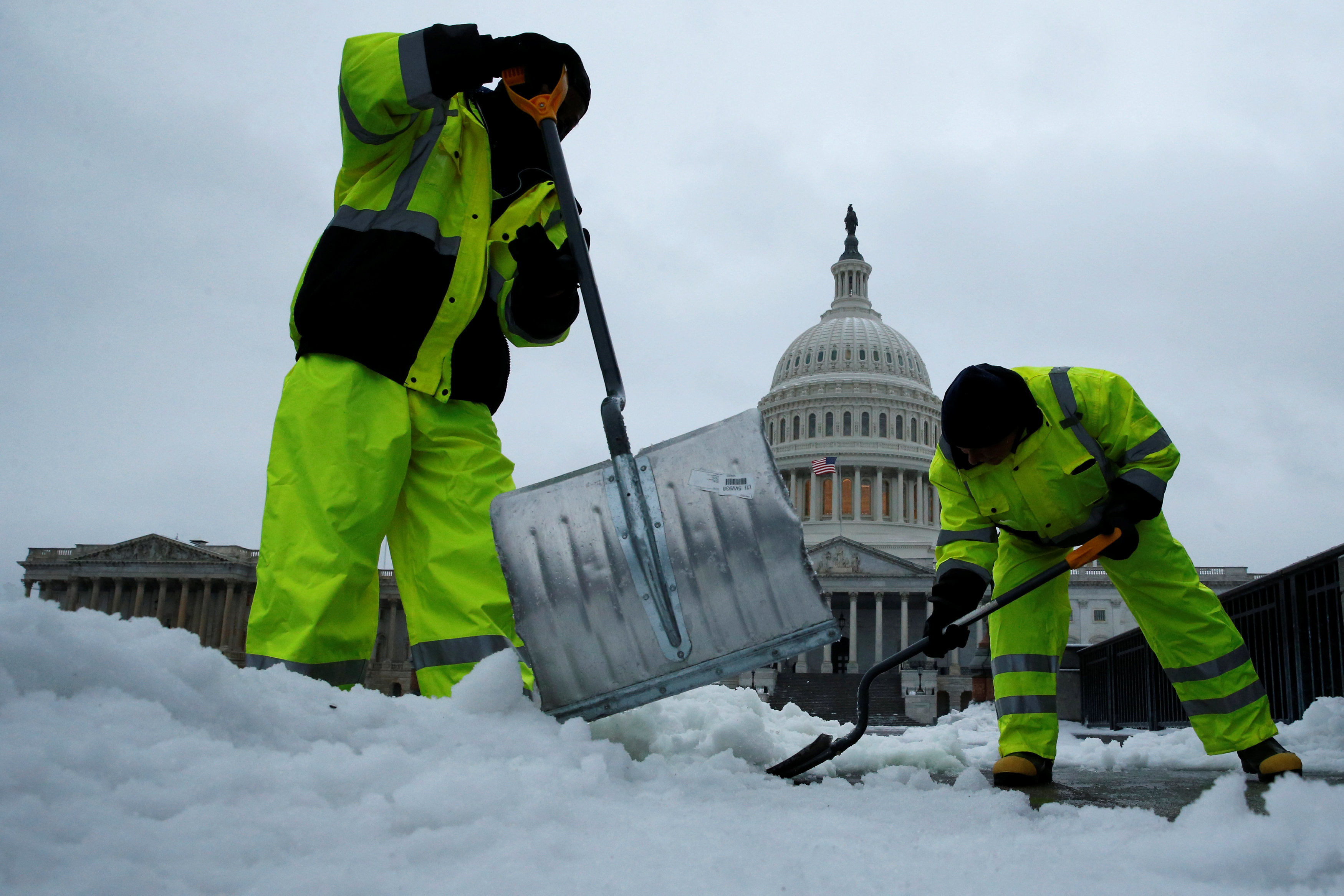
Workers clear frozen precipitation from a walkway at the U.S. Capitol in Washington, U.S., March 14, 2017. REUTERS/Jonathan Ernst

Workers clear frozen precipitation from a walkway at the U.S. Capitol in Washington, U.S., March 14, 2017. REUTERS/Jonathan Ernst

AIR TRAFFIC SNARLED

Airlines canceled about 5,500 flights across the United States, according to tracking service FlightAware.com. The airports with the most cancellations were Newark in New Jersey, LaGuardia in New York and Boston Logan International Airport.

American Airlines <AAL.O> canceled all flights into New York’s three airports – Newark, LaGuardia and John F. Kennedy International Airport – and JetBlue Airways <JBLU.O> reported extensive cancellations.

Delta Air Lines <DAL.N> canceled 800 flights for Tuesday for New York, Boston and other northeast airports. United Airlines <UAL.N> said it would have no operations at Newark or LaGuardia.

“We’re keeping a close eye on things and depending on how things go, will plan to ramp back up Wednesday morning,” United said in a statement.

New York City public schools – the largest U.S. school system – canceled classes on Tuesday as did schools in the Washington, D.C., area, Boston, Philadelphia and northern New Jersey.

Federal agencies in Washington said they were opening three hours later than normal on Tuesday.

The storm comes near the end of an unusually mild winter along much of the East Coast, with below-normal snowfalls in cities such as New York City and Washington.

Boston was braced for up to a foot of snow, which forecasters warned would fall quickly during the storm’s peak. The double-murder trial in Boston of former New England Patriots star Aaron Hernandez was suspended for the day because of the weather.

Washington, a city that functions badly with even small amounts of snow, was expecting 5 inches (13 cm) and twice that in outlying areas.

Snow fall was to be heavy at times with as much as 4 inches an hour expected to fall with winds reaching up to 60 mph (100 kph) in parts of the northeast, the National Weather Service warned.

Coastal flood warnings were also in effect for several parts of the region as a storm surge is expected during high tide on Tuesday, the weather service said.

German Chancellor Angela Merkel, who was due to meet President Donald Trump in Washington on Tuesday, postponed her trip until Friday, the White House said.

Shelves are seen scarce with bread at a Trader Joe's grocery store ahead of a fast-moving winter storm expected to hit the northeastern United States, in the borough of Manhattan in New York, U.S., March 13, 2017. REUTERS/Shannon Stapleton

Shelves are seen scarce with bread at a Trader Joe’s grocery store ahead of a fast-moving winter storm expected to hit the northeastern United States, in the borough of Manhattan in New York, U.S., March 13, 2017. REUTERS/Shannon Stapleton

(Additional reporting by Brendan O’Brien in Milwaukee, Laila Kearney and Jonathan Allen in New York and Scott Malone in Boston; Editing by Louise Ireland and Bill Trott)

Snow, cold to sweep across U.S. Northeast ahead of arctic blast

Person walking in high snow

(Reuters) – A snowstorm that pummeled the Midwest and grounded hundreds of flights will sweep across the U.S. Northeast on Monday, creating tough travel conditions ahead of the season’s first arctic blast, forecasters said.

The cold front that dumped more than 10 inches (25 cm) of snow on northern Illinois has prompted winter storm warnings and advisories as it also brings sleet and rain to New England and parts of the Middle Atlantic states, the National Weather Service said.

Accuweather, a private forecaster, said three to six inches (7.5 to 15 cm) of snow was expected to snarl travel in northern New York and New England. Local accumulations could be higher.

Conditions were expected to improve late on Monday as the system moves through the region. FlightAware, which tracks air travel, said 190 U.S. flights had been canceled on Monday after 1,800 were grounded on Sunday, mostly at Chicago’s two main airports.

The National Weather Service said another arctic air mass would spread over the northern Great Plains and Midwest in the next couple of days and then head east.

In the Northeast, “the cold weather will be more significant as we get into Thursday,” weather service meteorologist Brian Hurley said.

Accuweather said high temperatures would be in the single digits F (-17 to -12 C) to just below zero F (-18 C) from the Dakotas through Minnesota and Wisconsin as the cold air grips the region.

(Reporting By Ian Simpson in Washington; Editing by Daniel Wallis and Meredith Mazzilli)