Blizzard blows into northeast U.S.; flights canceled, schools shut

Cars are covered in snow in a general parking lot during the snowstorm at O'Hare International Airport in Chicago, Illinois, U.S., March 13, 2017. Some Chicagoland areas received up to 5 inches of snow, and more than 400 flights were cancelled at O'Hare. REUTERS/Kamil Krzaczynski

By Daniel Trotta and Scott Malone

NEW YORK/BOSTON (Reuters) – Snow piled up rapidly in parts of the northeastern United States on Tuesday as a blizzard began blowing in, with residents being advised to stay at home, airlines grounding flights and schools canceling classes.

The National Weather Service (NWS) warned some 50 million people from Pennsylvania to Maine of a “rapidly intensifying nor’easter” that was unusual for so late in the winter. Some could expect to find themselves surrounded by up to 2 feet (60 cm) of snow by early Wednesday, the federal agency predicted.

Governors in New York, New Jersey, Pennsylvania and Virginia declared states of emergency.

New York City was expected to escape the worst of it after the NWS withdrew its blizzard warning for the city on Tuesday morning, replacing it with a mere “winter weather advisory.” The service sharply reduced its snowfall forecast for the city to between 4 and 8 inches (10 and 20 cm).

Still, city life already was disrupted with many New Yorkers already planning to stay home with hard-won groceries picked up from crowded stores the night before.

New York Governor Andrew Cuomo suspended above-ground portions of the city’s subway service and said the Metro-North commuter service to the suburbs would shut down at noon. Transit officials warned that more bus and train routes might be suspended throughout the day.

“Normally, with the geography of New York, we normally have it on the east side or the west side. But this is statewide,” Cuomo told MSNBC in an interview.

“We’ve been through this a number of times so we’re prepared for it. Airports are basically closed … Government is basically closed, schools are basically closed, so there’s no real reason to be on the roads and we made that clear yesterday.”

Some 2,000 members of the National Guard and 5,000 plows were deployed across the state, Cuomo said.
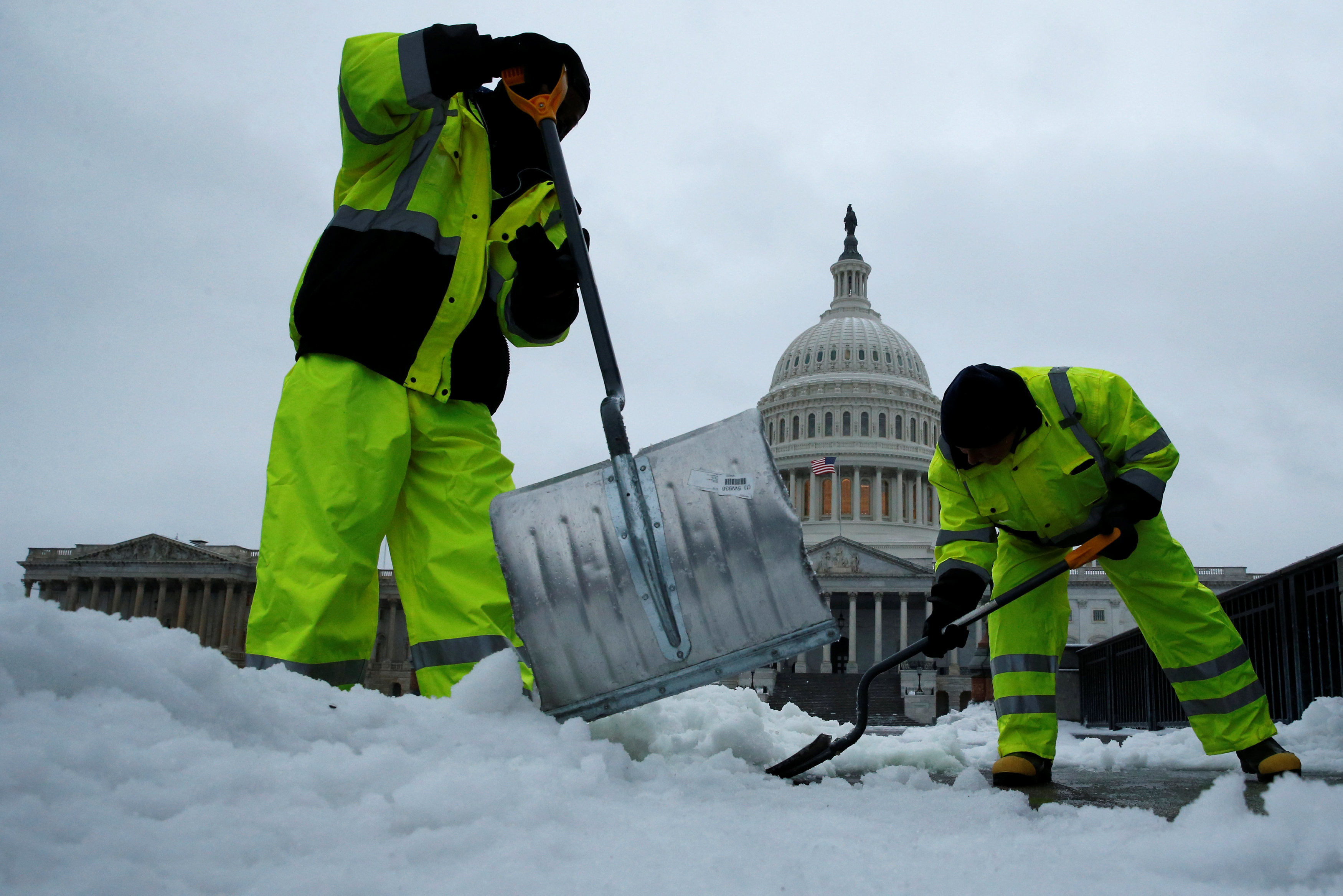
Workers clear frozen precipitation from a walkway at the U.S. Capitol in Washington, U.S., March 14, 2017. REUTERS/Jonathan Ernst

Workers clear frozen precipitation from a walkway at the U.S. Capitol in Washington, U.S., March 14, 2017. REUTERS/Jonathan Ernst

AIR TRAFFIC SNARLED

Airlines canceled about 5,500 flights across the United States, according to tracking service FlightAware.com. The airports with the most cancellations were Newark in New Jersey, LaGuardia in New York and Boston Logan International Airport.

American Airlines <AAL.O> canceled all flights into New York’s three airports – Newark, LaGuardia and John F. Kennedy International Airport – and JetBlue Airways <JBLU.O> reported extensive cancellations.

Delta Air Lines <DAL.N> canceled 800 flights for Tuesday for New York, Boston and other northeast airports. United Airlines <UAL.N> said it would have no operations at Newark or LaGuardia.

“We’re keeping a close eye on things and depending on how things go, will plan to ramp back up Wednesday morning,” United said in a statement.

New York City public schools – the largest U.S. school system – canceled classes on Tuesday as did schools in the Washington, D.C., area, Boston, Philadelphia and northern New Jersey.

Federal agencies in Washington said they were opening three hours later than normal on Tuesday.

The storm comes near the end of an unusually mild winter along much of the East Coast, with below-normal snowfalls in cities such as New York City and Washington.

Boston was braced for up to a foot of snow, which forecasters warned would fall quickly during the storm’s peak. The double-murder trial in Boston of former New England Patriots star Aaron Hernandez was suspended for the day because of the weather.

Washington, a city that functions badly with even small amounts of snow, was expecting 5 inches (13 cm) and twice that in outlying areas.

Snow fall was to be heavy at times with as much as 4 inches an hour expected to fall with winds reaching up to 60 mph (100 kph) in parts of the northeast, the National Weather Service warned.

Coastal flood warnings were also in effect for several parts of the region as a storm surge is expected during high tide on Tuesday, the weather service said.

German Chancellor Angela Merkel, who was due to meet President Donald Trump in Washington on Tuesday, postponed her trip until Friday, the White House said.

Shelves are seen scarce with bread at a Trader Joe's grocery store ahead of a fast-moving winter storm expected to hit the northeastern United States, in the borough of Manhattan in New York, U.S., March 13, 2017. REUTERS/Shannon Stapleton

Shelves are seen scarce with bread at a Trader Joe’s grocery store ahead of a fast-moving winter storm expected to hit the northeastern United States, in the borough of Manhattan in New York, U.S., March 13, 2017. REUTERS/Shannon Stapleton

(Additional reporting by Brendan O’Brien in Milwaukee, Laila Kearney and Jonathan Allen in New York and Scott Malone in Boston; Editing by Louise Ireland and Bill Trott)

Ice storm targets central United States

empty runway at natioanal airport due to ice

Reuters) – An ice storm heading for the central United States is threatening to cause power outages and create treacherous travel conditions on Friday and into the weekend, the National Weather Service said.

Ice, freezing rain and winter storm warnings were in effect for a large swathe of the Plains, from the Texas panhandle north into Iowa and east through central Indiana, the Weather Service said in an advisory.

“Significant amounts of ice accumulations will make travel dangerous or impossible,” the weather service said. “Travel is strongly discouraged. Commerce will likely be severely impacted.”

Ice accumulation could be more than half an inch (1 cm) depending on local temperatures, creating slick roadways especially on bridges and overpasses, and possibly causing scattered power outages across the region, the service said.

Oklahoma Governor Mary Fallin declared a state of emergency for the entire state ahead of the storm.

“Emergency personnel are coordinating with state and local officials to ensure we are prepared and ready for whatever comes our way,” said Fallin.

A handful of public school districts and universities in Idaho, Oklahoma and other parts of the central region have either canceled classes on Friday or had delayed openings due to the impending storm.

Parts of the region could also see as much as 3 inches (8 cm) of snow later in the weekend, according to the forecast.

(Reporting by Brendan O’Brien in Milwaukee; Editing by Janet Lawrence and Bernadette Baum)

Refugees brave snow, sub-zero temperatures in Greek camps

Syrian refugee boy in the snow

By Karolina Tagaris

RITSONA, Greece (Reuters) – Refugees stranded in Greece suffered sub-zero temperatures and heavy snowfall on Tuesday at camps not designed for winter weather and the government promised those on one island temporary warm accommodations aboard a navy ship.

A mid-winter icy spell and snowstorms have gripped central and southeastern Europe for days, and parts of Greece have been covered in rare snow with temperatures dipping to -20 degrees Celsius this week. Snow also fell in Athens on Tuesday.

More than 60,000 refugees and migrants have been trapped in Greece since Balkan countries along the main, northward overland route to wealthy western Europe sealed their borders last March. Most now live in overcrowded camps across Greece in abandoned factories or warehouses, or in tents which lack insulation or heating.

“Cold, it’s very cold for children – it’s not like Syria,” said Rostam, a 34-year-old Syrian Kurd who has been living in a camp near the village of Ritsona in eastern Greece near Athens for 10 months with his wife and three young children.

Temperatures hovered at -1 degrees at the camp, a collection shipping containers in a forest where clothes left on hanging on lines outdoors had frozen stiff.

Humanitarian aid organizations, including the United Nations refugee agency UNHCR, have pressed Greece to quickly transfer those on freezing, snowbound Aegean islands to the mainland or other European countries.

“The situation is very difficult and especially dangerous for children,” said George Protopapas, Greece director of international organisation SOS Children’s Villages.

“Power outages, freezing temperatures, snow and freezing rain have hampered access to some refugee camps and created very hazardous conditions for all those in temporary shelters.”

Conditions were considerably worse on the eastern Aegean island of Lesbos, where more than 5,000 asylum seekers have been waiting for months for their applications to be processed.

Scores of summer tents weighed down by thick snow resembled igloos after several days of icy weather on the island. On Tuesday, the government said it was sending a naval ship to Lesbos to accommodate migrants. It was also scrambling to transfer others to hotels.

“It is important to take immediate measures to ensure that men, women and children are housed in decent accommodation suitable for winter,” the Greek branch of global health charity Medecins du Monde said in a statement.

For some refugees who have been in limbo in Greece for months, things have been worse.

“It’s normal, we’re used to living like this,” said a 25-year-old Syrian who gave his name as Ahmad, one of the first to arrive in the Ritsona camp. “This is not one day or two days, this is 10 months.”

(Editing by Mark Heinrich)

Blizzard begins bearing down on Great Lakes, near-whiteout conditions expected

Portions of Illinois and Indiana were bracing for a blizzard on Wednesday.

The National Weather Service issued blizzard warnings for select counties in those states, saying high winds and heavy snow could generate near-whiteout conditions throughout the day.

The service said 6 to 12 inches of snow were expected across the warning area, and warned of wind gusts possibly reaching 50 mph. Travel was expected to be close to impossible during the height of the storm, and the warnings encouraged people to stay off the roads when possible.

The National Weather Service said snow had already begun falling on Wednesday morning.

More than 1,000 flights to or from Chicago’s airports had already been cancelled as of mid-day, according to flight monitoring website flightaware.com.

The Indiana State Police said they had responded to at least 46 crashes in just four hours, and the Indiana Department of Transportation reported multiple roads were closed due to incidents.

Some of the roads had since reopened, but the transportation department reported driving conditions were difficult on many roads in northwest Indiana. The state Department of Homeland Security issued numerous travel watches and advisories in that part of the state.

Broader winter storm warnings and winter weather advisories were also issued in other parts of Illinois and Indiana, as well as Missouri and Michigan. Winds were not expected to be as high in those areas, but the service said 6 to 12 inches of snow were still possible in many communities.

Residents of all of the affected states are encouraged to monitor their local forecasts.

Mid-Atlantic hit by winter storm, tornadoes reported in South

Portions of the mid-Atlantic remained under winter storm warnings on Tuesday morning, a day after snow fell along the East Coast and tornadoes were reported in four southern states.

The National Weather Service issued the warnings in parts of New York, Pennsylvania, Ohio, West Virginia, Maryland, Virginia and North Carolina, saying those regions should expect more winter weather this morning. Winter weather advisories were also issued across New England.

The winter weather is expected to transition into rain later today as temperatures rise. Residents of all of the affected states should monitor their local forecasts.

The storm came after several mid-Atlantic and New England communities recorded record low temperatures on Sunday, as bitter cold helped shatter the previous records for Valentine’s Day.

Notably, the National Weather Service said temperatures dipped to -1 degree Fahrenheit in New York’s Central Park, the coldest temperatures recorded on Feb. 14 in the park in 100 years.

In upstate New York, the service said temperatures reached 37 degrees below zero in Watertown and 23 degrees below zero in Syracuse. Those broke Feb. 14 records that had stood since 1979.

Monday’s winter storm brought snow and freezing rain to several states, and the National Weather Service reported a storm-high total of 15 inches fell near Rupert, West Virginia.

Parts of Virginia and Maryland received nine inches of snow, while cities in Kentucky and Tennessee saw more than six inches. Lighter totals were recorded in a broad area from Maine to Georgia, with some areas receiving some freezing rain.

The National Weather Service’s Storm Prediction Center also received 17 reports of tornadoes and high winds in Louisiana, Mississippi, Alabama and Florida on Monday.

The reports mentioned downed trees and power lines, damaged homes and buildings. The extreme weather caused at least one injury in Alabama, where Covington County officials reported a tornado destroyed a mobile home.

Tornadoes damaged nine homes, a school and a chicken house in Copiah County, Mississippi. The service also said a tree fell on a semi truck, briefly entrapping one person.

In Smith County, Mississippi, tornadoes caused “major damage to homes and structures” near Sylvarena, and blew a gas pump away from a grocery store.

Damage from heavy winds and hail was reported in several other southern communities.

The extreme weather, particularly the winter storm, had a significant impact on travel.

Flight monitoring website FlightAware.com reported 1,623 United States flight cancellations on Monday, including about 300 apiece at Washington’s Reagan National Airport and New York’s Laguardia Airport. More than 575 flights were cancelled on Tuesday morning, the site reported.

Winter storm targets East Coast, nearly 1,400 flights canceled

WASHINGTON/NEW YORK (Reuters) – An expansive winter storm bore down on the U.S. East Coast on Monday, scuttling almost 1,400 flights and threatening a treacherous wet commute on Tuesday after the holiday weekend.

As much as 5 inches of snow were expected to blanket Washington by nightfall, with less accumulation in New York City, before turning to freezing rain and then rain amid rising temperatures, National Weather Service meteorologist Patrick Burke said.

“It could be pretty tricky for the morning commute on Tuesday,” he said.

The New York City Emergency Management Department issued a travel advisory for Monday and Tuesday, warning residents about potentially slick roads and possible coastal flooding.

After record-breaking cold intensified by gusting winds gripped the U.S. Northeast over the Presidents Day holiday weekend, temperatures on Tuesday were predicted to rise as high as 56 degrees Fahrenheit in New York and 53 degrees in Washington. The milder temperatures were expected to stretch into the upcoming weekend.

“This system pushes the Arctic air out of here,” Burke added.

By mid-afternoon on Monday, almost 1,400 U.S. flights were canceled, mostly at Washington, North Carolina and New York-area airports, according to flight tracking website FlightAware.com. Many airlines waived change fees as more flights were scrapped.

Washington’s streets were nearly empty due to the holiday as well as the snow falling in heavy, wet flakes. Neil Emery, 54, a tourist from Nassau, Bahamas, said he, his wife and daughter had been shocked by the bitter cold but were reveling in the snowfall.

“It’s very Christmasy, really,” he said. The cold weather “is a good excuse for hot chocolates through the day.”

On the southern edge of the cold front, Mississippi was hit by heavy rain and at least one tornado, which downed trees and damaged a high school in Wesson, Mississippi, said National Weather Service forecaster Anna Wolverton.

Tornado watches were in place in Alabama and Louisiana. Heavy rains also drenched Tennessee, Virginia and West Virginia.

The vast storm stretched to western parts of Pennsylvania and New York, where Buffalo was expected to get more than 12 inches of snow.

New England ski resorts, struggling through a relatively warm and snowless winter, may receive up to 5 inches of snow, meteorologist Burke said.

(Reporting by Barbara Goldberg in New York and Ian Simpson in Washington; editing by Jeffrey Benkoe, Dan Grebler and G Crosse)

Bitterly cold wind chills expected in 22 states this weekend

Wind chill warnings or advisories were issued in parts of 22 states on Friday afternoon, as the National Weather Service cautioned that perceived temperatures could reach bitterly cold levels.

The service warned that the eastern United States is poised to see the coldest air mass of the season this weekend, and high winds are forecast to create dangerously low wind chills there.

The National Weather Service says overnight lows are expected to be in the single digits across New England, the mid-Atlantic and the Great Lakes on Saturday night and Sunday morning. Many regions could see sub-zero temperatures, with high winds making it feel even colder.

Wind chill warnings have been issued in parts of New England, New York, New Jersey and Pennsylvania. In one of the more extreme cases, the National Weather Service warned that wind chills of 45 degrees below zero were expected on Saturday night and Sunday morning in Maine.

“This will result in frost bite and lead to hypothermia or death if precautions are not taken,” the service’s wind chill warning states. Other warnings say the cold temperatures may freeze pipes.

Wind chill advisories were issued in parts of Minnesota, Iowa, Wisconsin, Illinois, Michigan, Indiana, Ohio, West Virginia, Virginia, North Carolina, Tennessee, Maryland and Delaware.

Some regions are expected to see wind chills of minus 25 or 30 degrees, the service said.

Winter storms are also in the forecast for some communities, and the National Weather Service issued lake effect snow warnings in portions of Wisconsin, Ohio, Pennsylvania and New York.

Some upstate New York communities were expecting as much as two feet of snow, and the service’s Buffalo office said negative-50 degree wind chills were possible in some areas.

In a statement, New York Governor Andrew Cuomo said his state hasn’t seen temperatures this low in a year. He encouraged his state’s residents to stay indoors and avoid unnecessary travel.

Residents of all of the affected states were encouraged to monitor their local forecasts.

Historic winter storm causes $2 billion in economic losses, report finds

The deadly winter storm that brought historic snowfall totals throughout the mid-Atlantic last month caused more than $2 billion in economic losses, a reinsurance company said Tuesday.

The storm was just one of the instances of extreme weather chronicled in Aon Benfield’s most recent monthly report on global catastrophes, which recap the economic effects of the events.

The report also detailed the impacts of extreme cold weather in Asia, flooding fueled by the El Nino weather pattern and earthquakes, wildfires and droughts that occurred in January.

The mid-Atlantic snowstorm, which The Weather Channel was calling Winter Storm Jonas, killed 58 people and led 11 states and the District of Columbia to declare states of emergency, according to the Aon Benfield report. The report noted the National Oceanic and Atmospheric Administration (NOAA) recently named the storm the fourth-biggest winter storm to hit that part of the United States in the past 66 years, according to its Northeast Snowfall Impact Scale.

The National Weather Service has said that snowfall totals reached double digits in 14 states, and portions of Connecticut, Delaware, Kentucky, Maryland, New Jersey, New York, Pennsylvania, Virginia and West Virginia all received more than a foot and a half of snow.

That included a storm-high 42 inches near Glengary, West Virginia, the service reported. Totals also topped 30 inches in parts of Virginia, Pennsylvania, New York, New Jersey and Maryland.

Some areas received record snow, spurring road closures and hundreds of flight cancellations. The Aon Benfield report’s $2 billion figure includes both physical damage and lost business.

Last month, the NOAA’s National Centers for Environmental Information reported the United States experienced 10 billion-dollar weather and climate disasters in 2015. If Aon Benfield’s numbers are accurate, the winter storm appears to be the first such disaster of the New Year.

Aon Benfield’s report also covers events that occurred outside the United States.

The company said Asia saw rare snowfall and some of its coldest temperatures in six decades, which killed at least 116 people in Taiwan, Thailand, Japan, South Korea and China last month. The report estimated the weather led to $2 billion in losses, $1.6 billion of which were in China.

Aon Benfield’s report also detailed several other January events with high economic impacts:

  • A hurricane-force windstorm led to hundreds of millions of dollars of losses in Europe
  • Severe drought caused South Africa’s agricultural industry to lose at least $250 million
  • Floods that killed 13 people in Ecuador and Brazil caused total losses to top $110 million
  • A five-day stretch of severe storms in California fueled more than $125 million in losses
  • A magnitude 6.7 earthquake in India killed 22 people and spurred $75 million in losses
  • A 176,000-acre wildfire in Western Australia led to $42 million in insurance claims alone

The report linked the California storms, South American flooding and South African drought to the El Nino weather pattern, which several scientists have said is one of the strongest on record.

The pattern occurs when a portion of the Pacific Ocean is warmer than usual, setting off a far-reaching ripple effect that brings atypical and often extreme weather across the world.

Blizzard sets sights on New England, forecasts call for a foot of snow

Parts of New England were preparing for a blizzard on Monday morning.

The National Weather Service issued a blizzard warning for southeastern Massachusetts, warning that 8 to 12 inches of heavy snow and wind gusts of 60 mph were in the forecast.

The service warned the storm could damage trees, cause power outages and lead to whiteout conditions, which may complicate travel. The blizzard warning expires at 7 p.m. this evening.

Snowfall totals were steadily on the rise on Cape Cod, with the National Weather Service reporting that 3.5 inches fell in Centerville, Massachusetts, in just four hours.

Other parts of Connecticut, Rhode Island, Massachusetts, Long Island and coastal New Hampshire were under less-severe winter storm warnings, though the National Weather Service was still calling for 4 to 10 inches of snow and wind gusts of up to 45 mph in those regions.

Lighter totals are forecast in Maine, New Jersey, New York and northern New Hampshire, which were under winter weather advisories. The service is calling for 2 to 6 inches of snow there.

Those advisories and warnings are set to expire tomorrow morning, according to the service.

The Weather Channel is calling the storm Winter Storm Mars.

The winter storm comes just two days after another winter storm knocked out power for at least 170,000 customers in Massachusetts, Connecticut and Rhode Island. About 5,000 customers in those states were without power as of 11 a.m. local time Monday, according to the Massachusetts Emergency Management Agency and local utility companies Eversource and National Grid.

The latest storm already led to more than 300 flight cancellations to or from Boston Logan International Airport, according to flight monitoring website FlightAware.com. Nearly 400 flights to or from the three airports that serve New York City were cancelled, the site reported.

Massachusetts governor Charlie Baker said that all non-emergency government employees in nine of the state’s 14 counties should not report to work on Monday. The Massachusetts State Police also tweeted that ferry service to Martha’s Vineyard and Nantucket had been suspended.

Separately, the National Weather Service issued blizzard warnings in parts of Iowa and Minnesota as another storm moves across the Great Plains. The service is only calling for an inch of snow, but 55 mph wind gusts could significantly reduce visibility through tonight.

“Travel is not advised in many areas,” the blizzard warning states.

The service also issued winter storm warnings in parts of Carolina and Tennessee, saying parts of the East Tennessee Mountains could see a foot of snow before Wednesday. Winter weather advisories were issued in several surrounding states, though lighter totals were expected there.

Residents of all the affected states should monitor their local forecasts.

More than 170,000 without power after New England snowstorm

More than 170,000 homes and businesses were without power on Friday afternoon after a winter storm brought more than a foot of snow to parts of southern New England.

The Massachusetts Emergency Management Agency reported 99,439 customers were without power, while Eversource indicated 48,149 of its Connecticut customers were experiencing outages. National Grid said the lights were off for 22,585 of its customers in Rhode Island.

The outages came after a winter storm dumped double-digit snowfall totals in all three states, according to the National Weather Service. That included 13 inches near Stafford Springs, Connecticut, 12.5 inches near Worcester, Massachusetts, and a foot in Burrillville, Rhode Island.

The Weather Channel is calling the storm Winter Storm Lexi.

Selected cities in New York, New Hampshire and Maine had received more than 7 inches of snow as of 3 p.m. local time, according to the National Weather Service, and counties in Maine, Rhode Island, Connecticut and Massachusetts were still under winter storm warnings at 4:30.

In a statement, Connecticut Governor Dannel P. Malloy said he was receiving updates from local utility companies and “remained concerned” about the power outages. Temperatures were expected to dip into the teens and 20s overnight, according to the National Weather Service.

“They are working to restore power to those who have lost it and continue to deploy crews to alleviate the situation,” Malloy said in his statement, referring to the utility companies. “However, we urge patience – the situation may take time to resolve.”

The storm also disrupted travel in the region.

More than 200 flights to or from Boston Logan International Airport had been cancelled, according to flight monitoring website FlightAware.com, and another 213 were delayed. There were more than 300 cancellations and 300 delays at LaGuardia Airport, FlightAware reported.

The Connecticut State Police tweeted it had responded to 341 crashes and a portion of Interstate 84 was temporarily closed. It encouraged drivers to stay off the road if possible.