What is left when Peru’s flood waters recede

A chair stands in mud at the home of Francisco Coca after rivers breached their banks due to torrential rains, causing flooding and widespread destruction in Carapongo Huachipa, Lima, Peru

By Mariana Bazo

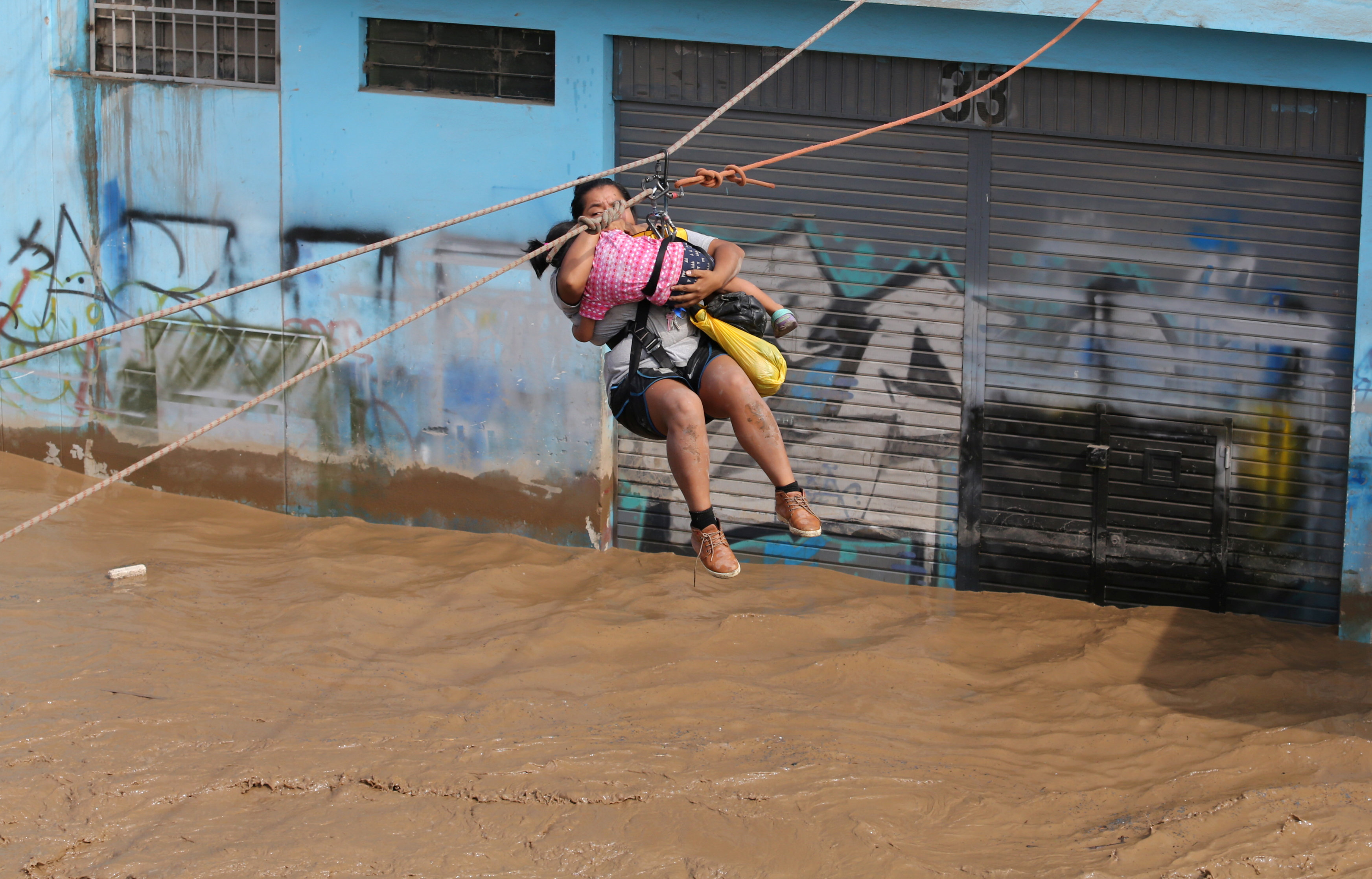
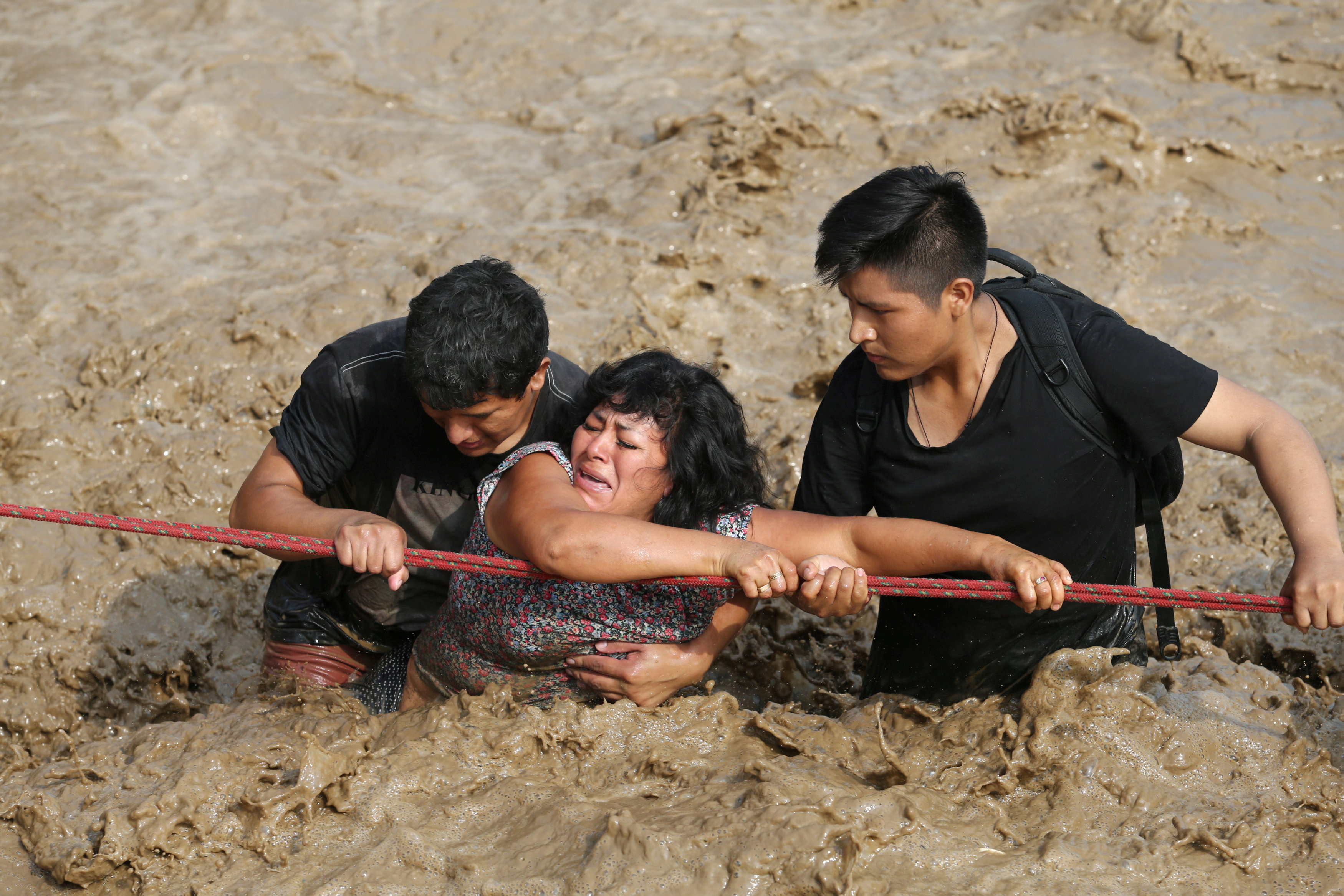
CARAPONGO, Peru (Reuters) – On the outskirts of Lima, hundreds of householders salvage scant belongings in what is left of their homes after the Rimac River burst its banks in recent weeks amid Peru’s worst flooding disaster in decades.

Many of the hardest hit are those who can least afford it – poor Peruvians who built their homes on cheap land near the river, which runs from Peru’s central Andes to the Pacific coast.

Simeona Mosquera contemplates her uncertain future, standing in what once was her front room and is now a ruin of mud and debris.

A children's bike leans against a wall covered in mud after rivers breached their banks due to torrential rains, causing flooding and widespread destruction in Carapongo Huachipa, Lima, Peru,

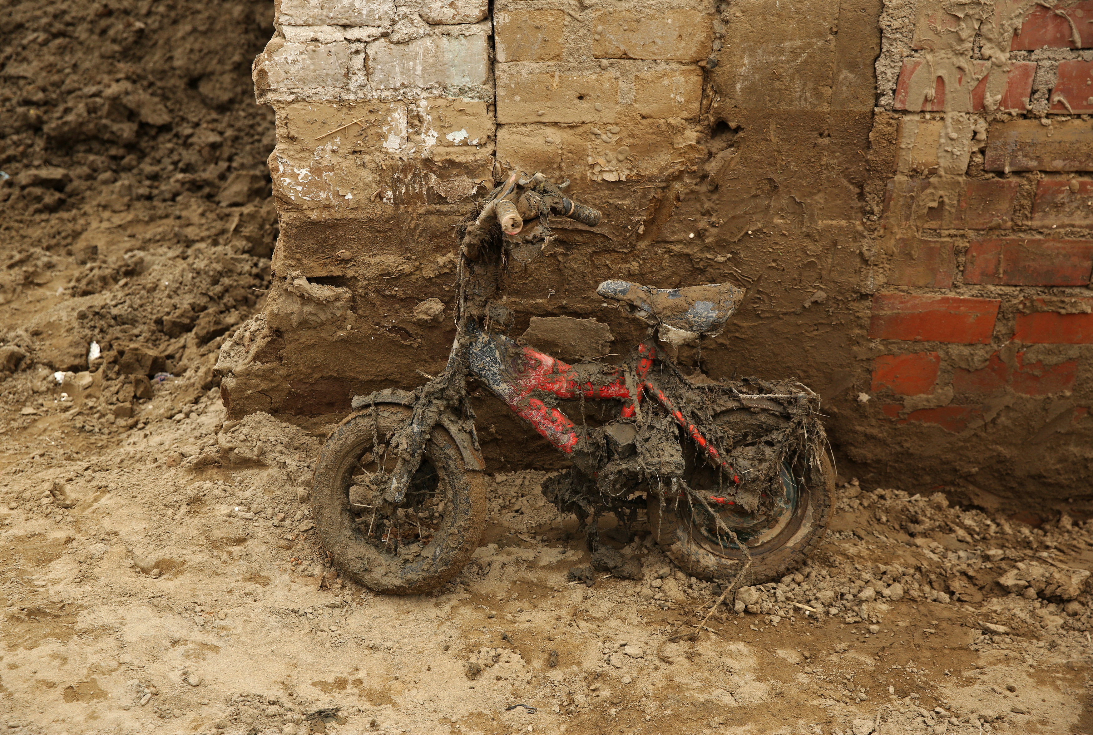
A children’s bike leans against a wall covered in mud after rivers breached their banks due to torrential rains, causing flooding and widespread destruction in Carapongo Huachipa, Lima, Peru, March 24, 2017. REUTERS/Mariana Bazo

The 74-year-old market seller fled in the night after a neighbor told her the waters were rising dangerously, but did not think anything would happen to her house.

“When I returned the next day I saw my sofa to one side, part of the house on another side, everything all over the place, everything destroyed,” she says. “I thought, am I dreaming or is this happening?

“I lost my sofas, my bed, my cupboards, my children’s documents … there is nothing left.”

Furniture that can be recovered is perched precariously on parts of brick walls, among the only remnants of nearby homes.

Across Peru, dozens have been killed and tens of thousands displaced after sudden warming of Pacific waters off the coast unleashed torrential downpours in recent weeks. It is part of a localized El Nino phenomenon that is forecast to stretch into April.

In what’s left of Carlos Rojas’ house a pink sign reading ‘Baby Shower’ hangs on a wall, one of the few things not coated with mud. It was for a party a couple of months ago for his baby daughter, the mechanic says. He brushes down a salvaged mattress. Not much else is left.

“All the things that cost me a lot of effort to earn went in no time at all,” say Rojas. “There’s no choice but to start again.”

(Click on http://reut.rs/2o9h1JB to see a related photo essay)

(Writing by Rosalba O’Brien; Editing by Jeffrey Benkoe)

Abnormal El Nino in Peru unleashes deadly downpours; more flooding seen

Residents do the laundry at a flooded Ramiro Priale highway, after rivers breached their banks due to torrential rains, causing flooding and widespread destruction in Huachipa, Lima, Peru, March 20, 2017. REUTERS/Mariana Bazo

By Mitra Taj

LIMA (Reuters) – A sudden and abnormal warming of Pacific waters off Peru has unleashed the deadliest downpours in decades, with landslides and raging rivers sweeping away people, clogging highways and destroying crops.

At least 62 people have died and more than 70,000 have become homeless as Peru’s rainy season has delivered 10 times as much rainfall than usual, authorities said Friday.

About half of Peru has been declared in emergency to expedite resources to the hardest hit areas, mostly in the north where rainfall has broken records in several districts, said Prime Minister Fernando Zavala.

Peru is bracing itself for another month of flooding.

A local El Nino phenomenon, the warming of surface sea temperatures in the Pacific, will likely continue along Peru’s northern coast at least through April, said Dimitri Gutierrez, a scientist with Peru’s El Nino committee.

Coastal El Ninos in Peru tend to be preceded by the El Nino phenomenon in the Equatorial Central Pacific, which can trigger flooding and droughts around the world, said Gutierrez. But this year’s event in Peru has developed from local conditions.

The U.S. weather agency has put the chances of an El Nino developing in the second half of 2017 at 50-55 percent.

While precipitation in Peru has not exceeded the powerful El Nino of 1998, more rain is falling in shorter periods of time – rapidly filling streets and rivers, said Jorge Chavez, a general tasked with coordinating the government’s response.

“We’ve never seen anything like this before,” said Chavez. “From one moment to the next, sea temperatures rose and winds that keep precipitation from reaching land subsided.”

Some scientists have said climate change will make El Ninos more frequent and intense.

In Peru, apocalyptic scenes recorded on cellphones and shared on social media have broadened the sense of chaos.

A woman caked in mud pulled herself from under a debris-filled river earlier this week after a mudslide rushed through a valley where she was tending to crops.

Bridges have collapsed as rivers have breached their banks, and cows and pigs have turned up on beaches after being carried away by rivers.

“There’s no need to panic, the government knows what it’s doing,” President Pedro Pablo Kuczynski said in a televised event, urging people to stay clear of rivers.

In Lima, the capital, classes have been suspended and running water has been restricted after treatment systems were clogged – prompting a rush on bottled water that produced shortages at some supermarkets.

The vast majority of people affected by the extreme weather are poor, including many who built makeshift homes on floodplains that had been dry for 20 years, said Chavez.

“There’s no electricity, no drinking water…no transit because streets are flooded,” said Valentin Fernandez, mayor of the town Nuevo Chimbote.

Chavez said Peru must rethink its infrastructure to prepare for the potential “tropicalization” of the northern desert coast, which some climate models have forecast as temperatures rise.

“We need more and better bridges, we need highways and cities with drainage systems,” said Chavez. “We can’t count on nature being predictable.”

(This story corrects to remove reference in first sentence to extreme weather in Peru being a sign of a potential El Nino; corrects sixth paragraph to show that Gutierrez said local El Ninos in Peru tend to be preceded, not followed by, the global El Nino pattern and that this year’s event in Peru has developed from local conditions)

(Reporting by Mitra Taj; Additional reporting by Reuters TV; Editing by Leslie Adler)

Abnormal El Nino in Peru unleashes deadly downpours; more flooding seen

People cross a flooded street after the Huayco river overflooded its banks sending torrents of mud and water rushing through the streets in Huachipa, Peru, March 17, 2017. REUTERS/Guadalupe Pardo

By Mitra Taj

LIMA (Reuters) – A sudden and abnormal warming of Pacific waters off Peru has unleashed the deadliest downpours in decades, with landslides and raging rivers sweeping away people, clogging highways and destroying crops in a potential sign of a global El Nino pattern this year.

At least 62 people have died and more than 70,000 have become homeless as Peru’s rainy season has delivered 10 times as much rainfall than usual, authorities said Friday.

About half of Peru has been declared in emergency to expedite resources to the hardest hit areas, mostly in the north where rainfall has broken records in several districts, said Prime Minister Fernando Zavala.

A woman and a child are evacuated with a zip line after the Huayco river overflooded its banks sending torrents of mud and water rushing through the streets in Huachipa, Peru, March 17, 2017. REUTERS/Guadalupe Pardo

A woman and a child are evacuated with a zip line after the Huayco river overflooded its banks sending torrents of mud and water rushing through the streets in Huachipa, Peru, March 17, 2017. REUTERS/Guadalupe Pardo

Peru is bracing itself for another month of flooding.

A local El Nino phenomenon, the warming of surface sea temperatures in the Pacific, will likely continue along Peru’s northern coast at least through April, said Dimitri Gutierrez, a scientist with Peru’s El Nino committee.

Local El Ninos in Peru tend to be followed by the global El Nino phenomenon, which can trigger flooding and droughts in different countries, said Gutierrez.

The U.S. weather agency has put the chances of an El Nino developing in the second half of 2017 at 50-55 percent.

While precipitation in Peru has not exceeded the powerful El Nino of 1998, more rain is falling in shorter periods of time – rapidly filling streets and rivers, said Jorge Chavez, a general tasked with coordinating the government’s response.

“We’ve never seen anything like this before,” said Chavez. “From one moment to the next, sea temperatures rose and winds that keep precipitation from reaching land subsided.”

Some scientists have said climate change will make El Ninos more frequent and intense.

A woman is assisted while crossing a flooded street after the Huayco river overflooded its banks sending torrents of mud and water rushing through the streets in Huachipa, Peru, March 17, 2017. REUTERS/Guadalupe Pardo

A woman is assisted while crossing a flooded street after the Huayco river overflooded its banks sending torrents of mud and water rushing through the streets in Huachipa, Peru, March 17, 2017. REUTERS/Guadalupe Pardo

In Peru, apocalyptic scenes recorded on cellphones and shared on social media have broadened the sense of chaos.

A woman caked in mud pulled herself from under a debris-filled river earlier this week after a mudslide rushed through a valley where she was tending to crops.

Bridges have collapsed as rivers have breached their banks, and cows and pigs have turned up on beaches after being carried away by rivers.

“There’s no need to panic, the government knows what it’s doing,” President Pedro Pablo Kuczynski said in a televised event, urging people to stay clear of rivers.

In Lima, the capital, classes have been suspended and running water has been restricted after treatment systems were clogged – prompting a rush on bottled water that produced shortages at some supermarkets.

The vast majority of people affected by the extreme weather are poor, including many who built makeshift homes on floodplains that had been dry for 20 years, said Chavez.

“There’s no electricity, no drinking water…no transit because streets are flooded,” said Valentin Fernandez, mayor of the town Nuevo Chimbote.

Chavez said Peru must rethink its infrastructure to prepare for the potential “tropicalization” of the northern desert coast, which some climate models have forecast as temperatures rise.

“We need more and better bridges, we need highways and cities with drainage systems,” said Chavez. “We can’t count on nature being predictable.”

(Reporting by Mitra Taj; Additional reporting by Reuters TV; Editing by Leslie Adler)

Weather forecasters see likelihood of La Nina August – Sept.

graphics showing the differences in temperature of an El Nino and El Nina

NEW YORK (Reuters) – Following a damaging El Nino weather period, a U.S. government weather forecaster on Thursday said the La Nina weather phenomenon is favored to develop during August through October 2016.

The Climate Prediction Center (CPC), an agency of the National Weather Service, said in its monthly forecast there is a 55 percent to 60 percent chance that the La Nina weather phenomenon will develop during the fall and winter of 2016/17.

Last month, the CPC forecast that La Nina was favored to develop during the Northern Hemisphere’s summer with a 75 percent chance of it developing in the fall and winter.

La Nina, which is typically less damaging than El Nino, is characterized by unusually cold ocean temperatures in the equatorial Pacific Ocean. It tends to occur unpredictably every two to seven years. Severe occurrences have been linked to floods and droughts.

Near-to below-average surface temperatures across the eastern equatorial Pacific Ocean were observed during the past month, the CPC said.

Last month, the agency said that El Nino conditions, a warming of sea-surface temperatures in the Pacific that has been linked to crop damage, fires and flash floods over the past year, had largely disappeared.

(Reporting by Marcy Nicholson; Editing by Chizu Nomiyama and Frances Kerry)

FAO launches new appeal for Ethiopia, warns millions at risk of going hungry

A potent El Nino has decimated the agriculture sector in Ethiopia and left more than 10 million of the country’s residents at risk of going hungry, a United Nations agency warned Monday.

The Food and Agriculture Organization (FAO) launched an urgent appeal for $13 million to help roughly 600,000 of the Ethiopian farmers who have been hit the hardest by the devastating crop and livestock losses brought on by one of the country’s worst droughts in history.

According to the FAO, the number of Ethiopians in need of humanitarian aid has tripled since January 2015, and about 10.2 million of them are currently food insecure. UNICEF warned last month that additional 6 million Ethiopians could need food assistance by the end of the year.

The FAO said the $13 million is needed by the end of the month to help ensure that farmers will be able to produce food during Ethiopia’s main growing season, when up to 85 percent of the nation’s total food supply is generated. Planting for an earlier rainy season was already delayed.

“We’re expecting that needs will be particularly high during the next few weeks,” Amadou Allahoury Diallo, the FAO’s country representative in Ethiopia, said in a statement. “So it’s critical that we’re able to respond quickly and robustly to reboot agriculture now before the drought further decimates the food security and livelihoods of millions.”

Ethiopia is one of several African nations that has been affected by an abnormally strong El Nino, a weather pattern known for producing extreme weather throughout the globe.

In a video released by the FAO on Monday, the organization’s Response Team Leader Rosanne Marchesich said some parts of Ethiopia have seen crop and livestock losses of 50 to 90 percent.

The eastern part of the country has witnessed “complete destruction,” she said.

In a news release, the FAO added “hundreds of thousands of livestock” in Ethiopia have died from a lack of water, feed shortages or poor grazing resources, and that die-off has fueled declines in milk and meat availability. Some farming families were forced to sell their final agricultural assets after last year’s losses, and others have been eaten planting seeds as food.

The organization said malnutrition is a growing concern.

The FAO added the $13 million will be used to supply feed and clean water to herding households, as well as safe water and seed support to farmers planning to grow crops.

El Niño leaves millions of Africans vulnerable to hunger, thirst, disease

A abnormally strong El Niño weather pattern and extreme droughts have left millions of Africans vulnerable to hunger, water shortages and disease, a United Nations agency warned on Wednesday, including about 1 million severely malnourished children who need treatment.

The U.N. Children’s Emergency Fund, or UNICEF, said those children are located in Eastern and Southern Africa, where the extreme weather has adversely affected food supplies. It said families there have skipped meals or sold some of their possessions to cope with rising prices.

In a statement, Leila Gharagozloo-Pakkala, the agency’s regional director for Eastern and Southern Africa, called the situation “unprecedented” and warned of a long-lasting effect.

“The El Niño weather phenomenon will wane, but the cost to children – many who were already living hand-to-mouth – will be felt for years to come,” Gharagozloo-Pakkala said.

Meteorologists have said this season’s El Niño is one of the strongest on record and its effects are likely to continue well into 2016. However, the U.N. Office for Humanitarian Affairs has estimated that areas affected by the El Niño-fueled drought will likely need two years to recover.

El Niño occurs when part of the Pacific Ocean is warmer than usual, setting off a ripple effect that brings atypical and often extreme weather throughout the world. It has been blamed for creating droughts in some nations and floods in others, both of which can destroy harvests.

Last week, four agencies issued a joint statement warning the weather pattern could devastate Southern Africa’s upcoming harvests. The World Food Programme, Food and Agricultural Organization, Famine Early Warning Systems Network and European Commission’s Joint Research Centre said parts of Southern Africa are in the midst of their driest season in 35 years, with Zimbabwe, Lesotho and many South African provinces declaring drought emergencies.

Other nations have implemented measures to reduce water consumption because of low levels.

Two of the harder-hit nations are South Africa and Malawi, and the agencies said maize prices surged to record-high levels in those countries. The agencies warned the window of opportunity to plant crops in Southern Africa had nearly closed, and forecasts point to another poor harvest.

“Over the coming year, humanitarian partners should prepare themselves for food insecurity levels and food insecure population numbers in southern Africa to be at their highest levels since the 2002-2003 food crisis,” the agencies warned, saying it was too early for an exact figure.

Any increase would add to the millions of people who currently need food aid.

That includes more than 10 million Ethiopians, a total UNICEF says could reach 18 million by December. The agency says children have skipped school because they have to search for water.

UNICEF says about 2.8 million people are at risk of going hungry in Malawi, while food insecurity poses an issue for 2.8 million Zimbabwe residents and 800,000 people in Angola.

El Niño has also brought heavy rains to Kenya, which UNICEF says is fueling cholera outbreaks.

The World Food Programme also recently said El Niño has hurt Haiti’s agriculture industry.

The weather isn’t the only the thing impacting people’s ability to secure food.

Violent conflicts have spurred food shortages in other nations, and the Famine Early Warning Systems Network says “emergency” conditions now exist in parts of South Sudan and Yemen.

Aid agencies call for funds to save lives in El Nino-hit countries

LONDON (Thomson Reuters Foundation) – An inadequate response to El Nino would put tens of millions of people at risk of hunger, water shortages and disease, a group of leading aid agencies said, calling on donors for funding to save lives in countries hit by the weather phenomenon.

The United Nations launched a record humanitarian appeal in December, asking for $20.1 billion to help 87 million people in 37 national and regional crises in 2016.

But some countries affected by El Nino, including Malawi, Zimbabwe, Papua New Guinea and El Salvador, were not included in the appeal, the humanitarian agencies said.

The aid groups, including Oxfam and World Vision, said “urgently required” funding should go into disaster preparedness, resilience building and crisis response, which would save money in the future.

“According to the United Nations, every $1 that is invested in disaster preparedness and resilience now could save up to $7 in emergency relief if a disaster unfolds over the coming months,” World Vision’s El Nino response director, Kathryn Taetzsch, said in a statement.

El Nino – a warming of sea-surface temperatures in the Pacific – affects wind patterns and can trigger both floods and drought in different parts of the world, leading to reduced harvests.

Ethiopia is one of the hardest hit countries and is experiencing its worst drought in decades. Some 8.2 million Ethiopians – out of a population of nearly 100 million – need food aid.

In Malawi, some 2.8 million people are struggling to feed themselves.

In Asia, poor harvests caused by lower than average rainfall linked to El Nino have hit Papua New Guinea particularly badly.

Central America, particularly El Salvador, Honduras and Nicaragua, along with Haiti and southeastern Brazil, have recorded below average rainfall this year, while heavy rains caused flooding in parts of Argentina and Peru.

According to the World Food Programme, an estimated 2.3 million people in Central America, mostly subsistence farmers, day laborers and their families, will need food assistance because of widespread damage to crops and rising food prices due to a prolonged drought exacerbated by El Nino.

The agencies said it was important to apply lessons learned from the 2011 Horn of Africa drought in which 258,000 died in Somalia alone. They cited a 2012 report which said that the response to the drought in Somalia was “too little, too late”.

“If the world acts now, we can help prevent disaster and suffering for millions of people – rather than waiting for people to start dying,” said Nigel Timmins, Oxfam International’s humanitarian director.

(Reporting by Magdalena Mis; Editing by Ros Russell)

California Rattled By Heavy Rains, Snow, Earthquake

Large portions of California were bracing for more heavy rain and snow Wednesday as El Niño pushed powerful storms toward the state, threatening to cause flash flooding and other damage.

The National Weather Service issued numerous flash flood watches along the California coastline and also issued winter storm warnings and winter weather advisories for areas in higher elevations. The service’s office in San Diego also warned of a chance for mudslides, particularly in areas where recent wildfires burned.

National Weather Service forecasts called for 2 to 4 inches of rain to fall across Southern California on Wednesday, accompanied by peak wind gusts of up to 60 mph that could be strong enough to topple trees and power lines. The rain comes a day after 1.42 inches fell at Los Angeles International Airport, smashing a daily rainfall record that stood for more than 36 years. Other parts of California received more than 3 inches of rain, National Weather Service data indicated.

The National Weather Service was calling for 5 to 10 inches of snow in higher elevations on Wednesday, but said mountain peaks could see 18 inches. Near-blizzard conditions were expected in some places. More storms were expected to drop additional precipitation tonight and Thursday.

Meanwhile, the United States Geological Survey reported a magnitude 4.5 earthquake occurred just outside of Banning, California, at 6:42 a.m. local time. The California Highway Patrol’s website indicated it received reports of small rocks and mud across state Route 243 a few minutes after the earthquake, though it wasn’t clear if the earthquake triggered the landslide.

Banning is located about 80 miles east of Los Angeles.

The National Weather Service also issued a flash flood warning for parts of Ventura County, just northwest of Los Angeles, cautioning that heavy rain could cause mud and debris to slide across busy Highway 101.

The storms were being blamed on El Niño, a weather pattern known for producing atypical and extreme weather throughout the world. It occurs when part of the Pacific Ocean is warmer than usual, which sets off a ripple effect that has a wide-reaching result. The National Oceanic and Atmospheric Administration has said that the United States is expected to see the effects of this El Niño over the next three months as one of the strongest instances of the phenomenon on record may sway temperatures and precipitation totals across significant portions of the nation.

Los Angeles opened up several shelters to help the city’s homeless population weather the storms.

New Forecast Provides Glimpse Into El Niño’s Potential U.S. Impacts

A new forecast provides an in-depth look at the weather conditions that a particularly powerful El Niño is expected to bring to the continental United States over the next three months.

The predictions were recently released by WSI, which has corporate connections to The Weather Channel. The channel analyzed the three-month outlook on its website on Monday.

El Niño is a weather pattern that occurs when part of the Pacific Ocean is warmer than usual, bringing atypical and sometimes extreme weather across the world. Many scientists, including those with NASA and World Meteorological Organization, have publicly said this year’s El Niño is shaping up to be one of the strongest instances of the pattern in the past 65 years, with NASA saying last week it may exceed the strength of the 1997-98 pattern billed as the worst on record.

According to The Weather Channel, the southern United States is generally expected to see temperatures below those typical for this time of year, while the northern states should see hotter-than-usual temperatures. The forecast indicates there may be exceptions to these tendencies, including a stretch this month where temperatures may see a more East-West divide.

El Niño is also known to impact precipitation totals.

Citing the National Oceanic and Atmospheric Administration (NOAA), which researches El Niño and issues its own predictions, The Weather Channel reported states on the Atlantic and Gulf coasts, as well as large chunks of the Great Plains and Southwest, should see above-average precipitation totals this winter. On the other hand, the report indicates states in the Great Lakes and Pacific Northwest, as well as those bordering Canada, may see less rain and snow than usual.

NASA warned last week that the United States likely has yet to see the full brunt of this El Niño, which has already been blamed for several extreme storms across the globe. El Niños also generate droughts in some parts and floods in others, disrupting economies and food supplies.

The forecast analyzed by The Weather Channel focused on general trends, not specific storms.

The NOAA is expected to release its next El Niño update on January 14.

NASA: Potent El Nino Shows No Signs of Slowing

The United States likely will not see the full force of a powerful El Nino until early next year and the weather phenomenon has not shown any sign of slowing down, NASA announced Tuesday.

El Nino occurs when part of the Pacific Ocean is warmer than usual, setting off a far-reaching ripple effect that brings atypical and often extreme weather throughout the world. A variety of weather experts, including those with the United Nations, have said this year’s pattern is shaping up to be one of the three strongest in the past 65 years, but NASA said that the latest satellite images suggest the United States probably has yet to see the worst of the weather.

The images show “a striking resemblance to one from December 1997,” captured during the strongest El Nino on record, according to NASA. While the National Weather Service previously said that the pattern “matured,” NASA said Tuesday that the latest images indicate El Nino “shows no signs of waning,” and the fact that some elements of the Pacific Ocean are different now than they were 18 years ago could mean the weather pattern might actually intensify.

“Although the sea surface height signal in 1997 was more intense and peaked in November of that year, in 2015, the area of high sea levels is larger,” Josh Willis, a project scientist at NASA’s Jet Propulsion Laboratory, told NASA’s website. “This could mean we have not yet seen the peak of this El Niño.”

The announcement comes in the wake of deadly flooding throughout the central United States that has sent multiple river gauges to historic levels and forced mandatory evacuations. This El Nino has already been blamed for historic flooding in coastal India, widespread wildfires in Indonesia and several crop-damaging droughts and floods across the globe, according to NASA.

NASA says it’s still not clear when El Nino will make its full presence felt in the United States, or the effects it could have. Generally, the National Weather Service has said the southeast is likely to see more precipitation and colder temperatures, while the northwest is expected to see hotter temperatures and less precipitation. However, that’s not an all-encompassing forecast, and NASA noted past El Ninos have been known to produce extreme storms such as a massive ice storm that slammed the northeast United States and parts of Canada in January 1998.

The National Weather Service has said El Nino is likely to linger into early summer.