Hundreds stranded in North Carolina floods after Hurricane Matthew

Men carry belongings from a neighbours home as flood waters rise after Hurricane Matthew in Lumberton, North Carolina,

By Judy Royal

CAROLINA BEACH, N.C. (Reuters) – Floodwaters left hundreds of people stranded in their homes and on rooftops in North Carolina early on Monday, and officials warned life-threatening flooding from swollen rivers would continue for days after Hurricane Matthew ravaged the southeastern United States.

Matthew, the most powerful Atlantic storm since 2007, was downgraded to a post-tropical cyclone on Sunday after its rampage through the Caribbean killed 1,000 people in Haiti.

In the United States, the death toll rose to at least 21 people with nearly half of the fatalities reported in North Carolina.

After receiving more than a foot (30 cm) of rain from Matthew during the weekend, skies were clear over North Carolina on Monday but the storm’s after-effects were creating major problems by overwhelming rivers and breaching levees.

“Hurricane Matthew is off the map, well into the ocean, but it still is right here in North Carolina,” Governor Pat McCrory said at a new conference on Monday. “This is an extremely dangerous situation.”

Ten people have died in the state, including a person killed after a car was driven into floodwaters and swept away in Johnston County on Sunday, McCrory said. With rivers rising, the governor said he expected the number of dead to increase.

Some 1,500 residents were stuck in their homes and on rooftops in Lumberton after an unexpected river levee breach Monday morning, McCrory said. Air and water rescues were underway in the city, where hundreds of people evacuated their homes overnight hours before the breach and floodwaters continued to rise quickly, he said.

McCrory said several other swollen rivers in the central and eastern parts of the state were expected to hit record levels and would crest throughout the week. Residents in several cities were urged to evacuate.

The National Weather Service said “life-threatening flooding” would continue on Monday over eastern portions of the state.

BREACHED DAMS

Many coastal and inland communities remained under water, either from coastal storm surge or overrun rivers and creeks.

All 2,000 residents of Princeville were told on Sunday to evacuate due to flash flood risks. The town lies on the Tar River about 25 miles (40 km) north of Greenville.

Several dams have breached in the area around Cumberland County, south of Raleigh, Michael Martin, fire marshal for the city of Fayetteville, said by phone.

Rescue teams still are on alert and there have been 1,400 people rescued. More than 600 National Guard troops were aiding in rescue and recovery efforts in the state.

In neighboring South Carolina, a vehicle trying to cross a flooded roadway in Florence County was swept away by floodwaters, killing one person, Governor Nikki Haley said on Sunday.

Jake Williams of Florence said on early Monday that his power had been out since Saturday morning.

“Trees are down in every neighborhood on almost every road,” he said. “I am no weather man but would guess that the gusts of wind were near 100 mph (160 km), and with soggy ground a lot trees couldn’t stand up to it.”

In Virginia Beach, the city said it had received more than 13 inches (33 cm) of rain and 55,000 people remained without power on Sunday night. The city said some 200 vehicles were abandoned and many roads remained impassable.

Norfolk, which declared a state of emergency, said efforts were underway to clear streets of debris and abandoned vehicles with city offices, libraries and recreational centers set to re-open Monday.

While power was being restored in some areas, 1.2 million people were without power in Florida, Georgia, North and South Carolina and Virginia, down from Sunday’s peak of 2.2 million.

Before the National Hurricane Center discontinued tropical storm warnings for Matthew, it was about 200 miles (320 km) off the coast of Cape Hatteras, North Carolina, and heading away from land as of late on Sunday.

The National Hurricane Center said on Monday morning that tropical storm Nicole was expected to strengthen into Tuesday. The storm was about 500 miles (800 km) south of Bermuda and moving northward toward the island.

The Atlantic hurricane season runs until Nov. 30.

(Writing by Timothy Mclaughlin and Laila Kearney; Editing by Colleen Jenkins and Bill Trott)

Focus shifts to recovery and flooding as Matthew heads out to sea

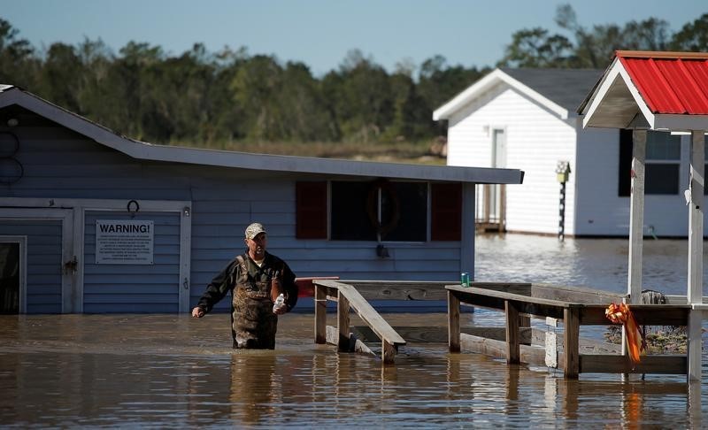
A Baptist church is surrounded by flood waters after Hurricane Matthew hit Lumberton, North Carolina

By Judy Royal

CAROLINA BEACH, N.C. (Reuters) – Residents of the southeastern United States ravaged by Hurricane Matthew turned their focus on Monday toward recovery and clean-up, but officials in several states warned that deadly flooding could continue as swollen rivers crest in the coming days.

Matthew, the most powerful Atlantic storm since 2007, was downgraded to a post-tropical cyclone on Sunday after its rampage through the Caribbean killed 1,000 people in Haiti.

In the United States, the death toll rose to at least 19 people.

While power was being restored in some areas, 1.6 million people were without power in Florida, Georgia, North and South Carolina and Virginia, down from Sunday’s peak of 2.2 million. Officials were working to clear streets of fallen trees and abandoned vehicles.

With five people reported missing and rivers rising, North Carolina Governor Pat McCrory said he expected the death toll to rise. Eight people in the state were known to have died so far.

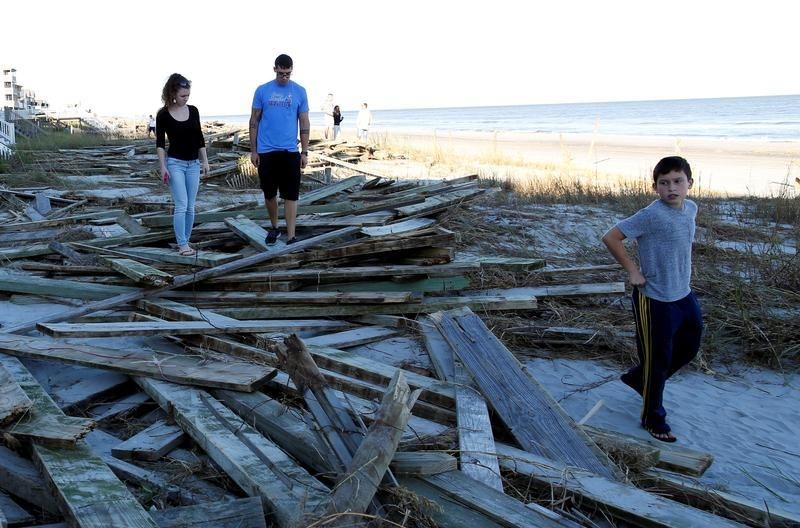
People look around the debris of the pier damaged by Hurricane Matthew in Surfside Beach, South Carolina,

People look around the debris of the pier damaged by Hurricane Matthew in Surfside Beach, South Carolina, U.S. October 9, 2016. REUTERS/Randall Hill

McCrory said several swelling rivers were expected to hit record levels and would not crest for days.

“Hurricane Matthew is off the map, but it is still with us and it is still deadly,” he said.

The National Weather Service said “life-threatening flooding” would continue on Monday over eastern portions of the state.

Many coastal and inland communities remained under water, either from coastal storm surge or overrun rivers and creeks.

All 2,000 residents of Princeville, were told on Sunday to evacuate due to flash flood risks. The town lies on the Tar River about 25 miles (40 km) north of Greenville.

Several dams have breached in the area around Cumberland County, south of Raleigh, Michael Martin, fire marshal for the city of Fayetteville, said by phone.

Swiftwater rescue teams are still on alert and there have been 255 water rescue calls and 701 people rescued.

In neighboring South Carolina, a vehicle trying to cross a flooded roadway in Florence County was swept away by flood waters, killing one person, Governor Nikki Haley said.

Jake Williams, a resident of Florence, said on early Monday that his power had been out since Saturday morning.

“Trees are down in every neighborhood on almost every road,” he said, adding “I am no weather man, but would guess that the gusts of wind were near 100 mph (160 km), and with soggy ground a lot trees couldn’t stand up to it.”

In Virginia Beach, the city said it had received over 13 inches (33 cm) of rain and 55,000 people remained without power on Sunday night. The city said that some 200 vehicles were abandoned and many roads remained impassable.

Norfolk, which declared a state of emergency, said efforts were under way to clear streets of debris and abandoned vehicles with city offices, libraries and recreational centers set to re-open Monday.

ROOFTOP RESCUE

The storm center was about 200 miles (320 km) off the coast of Cape Hatteras, North Carolina, and heading away from land, according to the National Hurricane Center’s Sunday 5 p.m. (2100 GMT) report. It discontinued all tropical storm warnings.

The storm still packed hurricane force winds as far as 90 miles (150 km) from the center and tropical-storm-force winds 240 miles (390 km) away.

U.S. President Barack Obama declared a state of emergency in Georgia and Florida, freeing up federal money to help the states repair damaged infrastructure and remove debris.

McCrory said 334 rescue workers risked their lives carrying out 877 rescues overnight.

In one of the dramatic rescues in North Carolina, out-of-state firefighters helped save three people from the roof of an SUV in inland Cumberland County, where more than 500 rescues took place.

Flash flooding turned a creek into a “roaring, raging river” that swept the vehicle off the roadway on Saturday night, said Battalion Chief Joe Downey of the Fire Department of New York. He was part of a team from three states that carried out 64 rescues on Saturday night and Sunday morning.

“Water was almost up to the roof of the SUV,” Downey said in a telephone interview. “It was bad. They had nowhere to go.”

Anthony Branch carries belongings from his home as flood waters rise after Hurricane Matthew in Lumberton, North Carolina

Anthony Branch carries belongings from his home as flood waters rise after Hurricane Matthew in Lumberton, North Carolina October 9, 2016. REUTERS/Chris Keane

Though Hurricane Matthew has moved out to sea, the Atlantic hurricane season, which runs until Nov. 30, remains active.

The National Hurricane Center said on Monday morning that tropical storm Nicole was expected to strengthen into Tuesday. The storm is around 500 miles (800 km) south of Bermuda and moving northward towards the island.

(Additional reporting by Harriet McLeod in Charleston, S.C., Eric Johnson in Seattle, and Frank McGurty, Chris Michaud and Gina Cherlus in New York, Writing by Timothy Mclaughlin; Editing by Alison Williams)

Hurricane Matthew batters Florida as Haiti death toll rises

Rain falls and winds caused by storm are seen while Hurricane Matthew approaches in Melbourne, Florida,

By Scott Malone and Gabriel Stargardter

ORLANDO, Fla./MIAMI, Oct 7 (Reuters) – The first major hurricane threatening a direct hit on the United States in more than 10 years lashed Florida on Friday with heavy rains and winds after killing at least 339 people in Haiti on its destructive march north through the Caribbean.

Hurricane Matthew packed gusts of 100 miles per hour (160 kph) as it tracked north-northwest along Florida’s east coast, the National Hurricane Center said in an advisory. The storm’s eye was 25 miles (40 km) east of Cape Canaveral, home to the  nation’s chief space launch site.

“We are seriously ground zero here in Cape Canaveral — hunkered down, lights flickering, winds are crazy,” said
resident Sandy Wilk on Twitter.

The storm downed power lines and trees and destroyed billboards in Cape Canaveral, reported Jeff Piotrowski, a
40-year-old storm chaser from Tulsa, Oklahoma.

“The winds are ferocious right now,” he said. “It’s fierce.”

NASA and the U.S. Air Force, which operate the Cape Canaveral launch site, took steps to safeguard personnel and
equipment. A team of 116 employees was bunkered down inside Kennedy Space Center’s Launch Control Center to ride out the
hurricane.

“We’ve had some close calls, but as far as I know it’s the first time we’ve had the threat of a direct hit,” NASA spokesman George Diller said by email from the hurricane bunker.

No significant damage or injuries were reported in West Palm Beach and other communities in south Florida where the storm downed trees and power lines earlier in the night, CNN and local
media reported.

About 300,000 Florida households were without power, local media reported. In West Palm Beach, street lights and houses went dark and Interstate 95 was empty as the storm rolled through the community of 100,000 people.

Hurricane Matthew was carrying extremely dangerous winds of  120 mph (195 kph) on Friday, but is expected to gradually weaken during the next 48 hours, the hurricane center said.

Matthew’s winds had dropped on Thursday night and into Friday morning, downgrading it to a Category 3 on the five-step Saffir-Simpson scale of hurricane intensity. It could either plow inland or tear along the Atlantic coast through Friday night, the Miami-based center said.

Few storms with winds as powerful as Matthew’s have struck Florida, and the NHC warned of “potentially disastrous impacts.”

The U.S. National Weather Service said the storm could be the most powerful to strike northeast Florida in 118 years.

A dangerous storm surge was expected to reach up to 11 feet (3.35 meters) along the Florida coast, Ed Rappaport, deputy director of the Miami-based NHC, said on CNN.

“What we know is that most of the lives lost in hurricanes is due to storm surge,” he said.

Some 339 people were killed in Haiti, local officials said, and thousands were displaced after the storm flattened homes, uprooted trees and inundated neighborhoods earlier in the week. Four people were killed in the Dominican Republic, which neighbors Haiti.

Damage and potential casualties in the Bahamas were still unclear as the storm passed near the capital, Nassau, on
Thursday and then out over the western end of Grand Bahama Island.

It was too soon to predict where Matthew might do the most damage in the United States, but the NHC’s hurricane warning extended up the Atlantic coast from southern Florida through Georgia and into South Carolina. More than 12 million people in the United States were under hurricane watches and warnings, according to the Weather Channel.

The last major hurricane, classified as a storm bearing sustained winds of more than 110 mph (177 kph), to make landfall on U.S. shores was Hurricane Wilma in 2005.

Jeff Masters, a veteran hurricane expert, said on his Weather Underground website (www.wunderground.com) that Matthew’s wind threat was especially serious at Cape Canaveral, which juts into the Atlantic off central Florida.

“If Matthew does make landfall along the Florida coast, this would be the most likely spot for it. Billions of dollars of facilities and equipment are at risk at Kennedy Space Center and nearby bases, which have never before experienced a major hurricane,” Masters wrote.

‘AS SERIOUS AS IT GETS’

Roads in Florida, Georgia and North and South Carolina were jammed, and gas stations and food stores ran out of supplies as the storm approached early on Thursday.

Governor Rick Scott warned there could be “catastrophic” damage if Matthew slammed directly into the state and urged some 1.5 million people there to evacuate.

Scott, who activated several thousand National Guard troops to help deal with the storm, warned that millions of people were likely to be left without power.

Florida, Georgia and South Carolina opened shelters for evacuees. As of Thursday morning, more than 3,000 people were being housed in 60 shelters in Florida, Scott said.

Those three states as well as North Carolina declared states of emergency, empowering their governors to mobilize theNational Guard.

President Barack Obama called the governors of the four states on Thursday to discuss preparations for the storm. He declared a state of emergency in Florida and South Carolina, a move that authorized federal agencies to coordinate disaster relief efforts. Late Thursday, Obama declared an emergency in Georgia and ordered federal aid to the state.

“Hurricane Matthew is as serious as it gets. Listen to local officials, prepare, take care of each other,” Obama warned people in the path of the storm in a posting on Twitter.

Hundreds of passenger flights were canceled in south Florida, and cancellations were expected to spread north in
coming days along the storm’s path, airlines including American Airlines, Delta Airlines and United Airlines
said.

(Reporting by Brendan O’Brien in Milwaukee, Neil Hartnell in Nassau, Rich McKay in Atlanta, Nick Carey in Chicago, Harriet McLeod in Charleston, S.C., Doina Chiacu in Washington, Joseph Guyler Delva in Haiti, Irene Klotz and Laila Kearney; Writing by Frances Kerry and Tom Brown; Editing by Catherine Evans)

Lurking Hermine spares much of U.S. East Coast, could regain hurricane strength

Tropical Storm Hermine is pictured off the coast of the U.S. Mid-Atlantic

By Daniel Trotta and Chris Prentice

NEW YORK (Reuters) – Atlantic storm Hermine, which has killed two people, lurked off the middle of the U.S. East Coast late on Sunday while threatening to regain hurricane strength, after having spared the region the brunt of its wind, rain and tidal surge.

Forecasters warned swimmers and boaters to avoid the risk of deadly surf churned up by the storm and stay out of treacherous waters during the Labor Day holiday weekend, when many Americans celebrate the end of summer.

Hermine was still packing maximum sustained surface winds of nearly 70 mph (113 kph) late on Sunday, and forecasters said it  could intensify slightly to reach hurricane strength again, before it starts to dwindle later on Monday.

But for now, its strongest winds were extending outward by about 230 miles (370 km), failing to reach U.S. shores.

Hermine was forecast to bring up to 2 inches (5 cm) of rain to southern New England on Monday, after having hit land in Florida on Friday, and churning up the southeastern seaboard.

Sandbags and tarps cover the entrance to a subway station near Battery Park as New York City prepares for potential flooding as post-tropical storm Hermine stalls off the east coast of the United States

Sandbags and tarps cover the entrance to a subway station near Battery Park as New York City prepares for potential flooding as post-tropical storm Hermine stalls off the east coast of the United States, September 4, 2016. REUTERS/Mark Kauzlarich

Then it merged with a conventional weather front, to be reclassified on Saturday as a post-tropical cyclone.

But Hermine was not expected to make landfall again, said Robbie Berg, an official of the National Hurricane Center.

A tropical storm warning remained in effect Sunday night from the Delaware and New Jersey shores north to New York’s Long Island and beyond to Martha’s Vineyard and Nantucket Island off Massachusetts, but was canceled for New York City, which Berg said appeared largely out of harm’s way.

Potential storm-surge inundation levels of no more than 1 to 3 feet (30 cm to 1 m) were expected in coastal areas.

As the threat to New Jersey waned, Governor Chris Christie ordered Island Beach State Park reopened for Monday, while warning that lingering rip currents and rough surf might still make the ocean unsafe for swimmers.

At 11 p.m. EDT on Sunday, Hermine’s center was about 325 miles (523 km) southeast of Long Island, the eastern tip of New York, the hurricane center said.

It was expected to “meander slowly” off the mid-Atlantic region, moving north-northeast at only 3 mph (5 kph) and stay at least 300 miles (480 km) from shore before beginning to weaken by Monday night, the agency said.

WANING STORM THREAT BEYOND COAST

The storm claimed at least two lives, in Florida and North Carolina, but the widespread power outages and flooding that battered Florida, Georgia and the Carolinas had yet to materialize farther north, where alarming news reports scared many tourists away from the beach on Sunday.

Those who stayed awoke to sunshine, but stronger-than-usual winds and choppy seas.

“It was a little overhyped by the media,” said Andrew Thulin, assistant general manager of Daddy O Hotel Restaurant in the New Jersey township of Long Beach.

“It killed the weekend for everybody down here.”

Officials mindful of the 2012 devastation of Superstorm Sandy took every precaution. Elsewhere in the state coastal roads were reported flooded, and beaches engulfed by the sea.

Hermine became the first hurricane to make landfall in Florida in 11 years, packing winds of 80 mph (129 kph), and knocking out power to 300,000 homes and businesses. Downgraded to a tropical storm within hours, it still packed a wallop.

(Additional reporting by Steve Gorman from Los Angeles and Chris Michaud from New York)

Tropical Storm Hermine pounds into the Carolinas

Three storm systems are shown (L TO R) Tropical Depression Nine to the southeast of Florida,

By Letitia Stein

TAMPA, Fla., Sept 2 (Reuters) – Hurricane Hermine wreaked havoc across Florida on Friday, causing widespread power outages and flooding before diminishing into a tropical storm and plowing up the Atlantic Coast into the Carolinas with a still-potent mix of high winds and heavy rains.

The first hurricane to make landfall in Florida in 11 years Hermine swept ashore early on Friday near the Gulf shore town of St. Marks, 20 miles (30 km) south of the capital of Tallahassee, packing winds of 80 mph (130 kph) and churning up a devastating storm surge in coastal areas.

Torrential downpours and high surf left parts of some communities under water early Friday, with mandatory evacuations ordered in parts of five northwestern Florida counties.

State officials said electricity had been knocked out to nearly 300,000 homes and businesses by afternoon.

One storm-related death was reported by authorities in the northern Florida town of Ocala, where a fallen tree killed a homeless man sleeping in his tent.

Hermine was expected to snarl Labor Day holiday travel as it churned northeast for several more days after battering Florida’s $89 billion tourism industry.

While maximum sustained winds had weakened to 50 mph (80 kph), the tempest headed to the Atlantic seaboard along a path inhabited by tens of millions of Americans, prompting storm
watches and warnings as far north as Rhode Island.

As of 9 p.m. EDT (0100 GMT), the fourth named storm of the 2016 Atlantic hurricane season was passing near Myrtle Beach, South Carolina, leaving some 51,000 power outages across the state, said state emergency management spokesman Derrec Becker.

Becker said localized flooding hit low-lying areas across the state, and there were widespread reports of “downed power lines, downed trees, trees on cars and some flooded cars,” along with isolated incidents of tree-damaged homes.

One mobile home was virtually sliced in two by a fallen tree, but authorities had no reports of serious storm-related injuries or fatalities, Becker added.

Likewise, emergency officials reported no storm deaths in Georgia, which Hermine swept through on its way to South Carolina, but said at least 100,000 utility customers were
without power at one point.

Emergency declarations remained in effect for all or parts of Florida, Georgia, North Carolina, Virginia and Maryland.

LIKELY TO REGAIN STRENGTH

The storm was projected to creep north along the Carolina coast Friday night, then gather strength after moving offshore into the Atlantic on Saturday morning, possibly reaching near-hurricane intensity by late Sunday, according to the National Hurricane Center.

In addition to powerful winds extending up to 185 miles (295 km) from its center, Hermine was expected to unleash a dangerous storm surge in the Hampton Roads area of tidewater Virginia, where flooding could become 3 to 5 feet deep, the NHC warned.

The storm also could douse several southeastern and mid-Atlantic states with up to 15 inches (38 cm) of rain through Sunday, the agency said.

New Jersey, still mindful of devastation from superstorm Sandy in 2012, was on high alert as emergency officials advised residents to prepare for flooding, high winds and a surge of
seawater.

New York Governor Andrew Cuomo on Friday activated his state’s emergency operations center and ordered officials to stockpile resources, including sandbags and generators.

New York City Mayor Bill De Blasio said residents should avoid beach waters for fear of life-threatening riptides. “I say that to people who go the beach, I say that to surfers: Don’t even think about it,” De Blasio told reporters.

In Florida, concerns over the standing water in which mosquitoes breed intensified as the state battled an outbreak of the Zika virus.

“It is incredibly important that everyone does their part to combat the Zika virus by dumping standing water, no matter how small,” Florida Governor Rick Scott told a news conference.

Overnight, crews in Pasco County, Florida, rescued more than a dozen people after their homes were flooded.

Richard Jewett, 68, was rescued from his home in New PortRichey, just north of Tampa, as emergency teams carried out amandatory evacuation.

“The canal started creeping up toward the house, and even though it wasn’t high tide it looked like it was coming inside,” Jewett said.

(Additional reporting by Zachary Fagenson in Hudson Beach,
Fla., Steve Gorman in Los Angeles, Brendan O’Brien in Milwaukee,
Laila Kearney in New York and Jon Herskovitz in Austin; Editing
by Daniel Trotta and Cynthia Osterman)

Hermine tears through Florida, raises new Zika fears

Robert Long and his son J.D. watch workers removing downed trees during cleanup operations in the aftermath of Hurricane Hermine in Tallahassee

By Letitia Stein

TAMPA, Fla. (Reuters) – Hurricane Hermine tore a path of destruction across Florida on Friday, knocking out power for 253,000 customers, flooding low-lying areas and raising concerns about the spread of the Zika virus from pools of standing water left behind.

The first hurricane to make landfall in Florida in more than a decade, Hermine came ashore early on Friday near St. Marks, Florida, 20 miles (30 km) south of the capital of Tallahassee, packing winds of 80 mph (130 kph) and churning up a devastating storm surge in coastal areas.

Hermine, which has since been downgraded to a tropical storm, was set to snarl U.S. Labor Day holiday travel as it moves northeast after battering Florida’s $89 billion tourism industry.

The storm center was on the border between Georgia and South Carolina at 2 p.m.(1800 GMT), the National Hurricane Center (NHC) said.

A huge pine tree is shown after falling through a home from the wind and rain damage of Hurricane Hermine in Tallahassee, Florida

A huge pine tree is shown after falling through a home from the wind and rain damage of Hurricane Hermine in Tallahassee, Florida September 2, 2016. REUTERS/Phil Sears REUTERS/Phil Sears


Though sustained winds had weakened to 50 mph (80 kph), the tempest headed toward the Atlantic seaboard on a path where tens of millions of Americans live, causing storm watches and warnings stretching to Rhode Island, NHC said.

It could strengthen again over water and possibly bring up to 15 inches (38 cm) of rain to the southeastern and mid-Atlantic states over the next 48 hours, with heavy rainfall possibly hitting coastal Delaware and New Jersey starting on Saturday night, the center said.

New Jersey, still mindful of the devastation caused by Hurricane Sandy in 2012, was on high alert as emergency officials advised people to prepare for flooding, high winds and a surge of seawater.

New York Governor Andrew Cuomo on Friday activated his state’s emergency operations center and advised emergency officials to stockpile resources, including sandbags and generators.

As it tracks north offshore towards New York, the storm is projected to stall at sea through Wednesday morning, the National Hurricane Center said.

New York Mayor Bill De Blasio said residents should avoid beach waters for fear of life-threatening riptides caused by the lingering storm. “I say that to people who go the beach, I say that to surfers: Don’t even think about it,” De Blasio told a news conference.

WORRIES ABOUT ZIKA

In Florida, concerns over the standing water in which mosquitoes breed intensified as the state battles an outbreak of the Zika virus.

“It is incredibly important that everyone does their part to combat the Zika virus by dumping standing water, no matter how small,” Florida Governor Rick Scott told a news conference, also warning people to look for downed power lines and avoid driving in standing water pools.

There have been 47 cases of Zika in people believed to have contracted the virus through local mosquitoes, according to the Florida Department of Health. Active transmission is thought to be occurring in two small areas around Miami.

As the sun rose on Friday morning on Hudson Beach, just north of Tampa, cars sat askew in flooded roads. Palm fronds, tree branches and garbage cans were scattered about.

Overnight, Pasco County crews rescued more than a dozen people after their homes were flooded.

Richard Jewett, 68, was rescued from his home in New Port Richey, just north of Tampa, around 1:30 a.m. EDT (0530 GMT) as emergency workers carried out a mandatory evacuation.

“The canal started creeping up toward the house and even though it wasn’t high tide it looked like it was coming inside,” Jewett said.

In Cedar Key, an island community in northwest Florida, waters rose more than 9.5 feet (2.9 meters), among the highest surges ever seen, the National Weather Service said.

“This is one of the worst that we have seen in the city in a long time, and unfortunately, it is not over yet,” St. Petersburg, Florida, Mayor Rick Kriseman told reporters.

(Additional reporting by Zachary Fagenson in Hudson Beach, Fla., Brendan O’Brien in Milwaukee, Laila Kearney in New York and Jon Herskovitz in Austin; Editing by Daniel Trotta and Cynthia Osterman)

California power grid passes first heat wave test amid gas shortage

Lost Angeles skyline

(Reuters) – California’s power grid passed its first test of the summer with no rolling blackouts on Monday, when customers cranked up their air conditioners as temperatures soared into the triple-digits for the second consecutive day in some southern parts of the state.

The California Independent System Operator, which manages the state’s power grid, issued a so-called flex alert on Sunday, urging homes and businesses to conserve energy on Monday afternoon.

As consumers heeded that call and temperatures on Monday came in a little cooler than expected, the ISO cut its peak power demand projection for the day to 43,728 megawatts from 45,316 MW.

Monday’s alert was the first big test of power generators’ ability to meet heightened energy demands in the greater Los Angeles area without natural gas supplies normally furnished by the now-crippled Aliso Canyon. The storage field, California’s largest, has been effectively idled since a major well rupture there last autumn.

So far, the ISO has not issued another flex alert for Tuesday but said on its website it would be “helpful” if customers conserve energy.

With cooler temperatures expected for the rest of the week, the ISO forecast demand would peak at 42,581 MW on Tuesday and just 39,036 on Wednesday.

AccuWeather meteorologists forecast the mercury would reach 87 degrees Fahrenheit (31 Celsius) in Los Angeles on Tuesday before falling to a near-normal 82 degrees on Wednesday. They had exceeded 100 degrees on Monday.

With Aliso Canyon shut down, state regulators have warned that the Los Angeles area faces up to 14 days of gas shortages severe enough to trigger blackouts this summer.

Aliso Canyon, owned by Sempra Energy’s Southern California Gas Co unit, normally supplies the region’s 17 gas-fired power plants, hospitals, refineries and other key parts of the state’s economy.

(Reporting by Scott DiSavino; Editing by Lisa Von Ahn)

California power grid prepares for heatwave, possible natgas shortage

By Scott DiSavino

(Reuters) – California will have its first test of plans to keep the lights on this summer following the shutdown of the key Aliso Canyon natural gas storage facility as temperatures in the Los Angeles area are forecast to hit triple digits this week.

With record-setting heat and air conditioning demand expected in Southern California, the state’s power grid operator issued a so-called “flex alert,” urging consumers to conserve energy to help prevent rotating power outages – which could occur regardless.

Electricity demand is expected to rise during the unseasonable heatwave on Monday and Tuesday, with forecast system-wide use expected to top 45,000 megawatts, said the California Independent System Operator (ISO), which manages electricity flow through the state. That compares with a peak demand of 47,358 MW last year and the all-time high of 50,270 MW set in July 2006.

That could put stress on the power grid, particularly with the shut-in of Aliso Canyon, following a massive leak at the underground storage facility in October. The facility, in the San Fernando Valley, is the second largest storage field in the western United States, according to federal data, and therefore crucial for power generation.

All customers, including homes, hospitals, oil refineries and airports are at risk of losing power at some point this summer because a majority of electric generating stations in California use gas as their primary fuel. In April, millions of electric customers in Southern California were warned they could suffer power outages on up to 14 days this summer due to the closure.

The ISO said it was working with gas and power utilities and state energy agencies to mitigate potential reliability issues related to the limited operations at Aliso Canyon.

“We are confident we have a strong plan in place to meet the operational challenges posed by the upcoming hot temperatures,” ISO CEO Steve Berberich said, adding that consumer conservation efforts would be key.

ROTATING OUTAGES

Since the energy crisis of 2000-2001, the ISO has imposed short rotating outages in 2004, 2005, 2010 and 2015, mostly related to unexpected transmission line or power plant outages during periods of unusually high demand.

Southern California Gas (SoCalGas), the nation’s biggest gas distribution utility and owner of Aliso Canyon, detected the leak in October and plugged it in February.

SoCalGas is a unit of California energy company Sempra Energy.

State regulators will not allow SoCalGas to inject fuel into the facility until the company inspects all of its 114 wells.

Aliso Canyon is the biggest of four SoCalGas storage fields. It provides service to the region’s 17 gas-fired power plants, hospitals, refineries, and other key parts of California’s economy.

In the summer (April through October), SoCalGas strives to completely fill 86.2-billion cubic feet (bcf) Aliso Canyon to prepare for the upcoming winter heating season when gas demand peaks.

State regulators, however, ordered the company in January to reduce the amount of working gas in Aliso Canyon to just 15 bcf and use that fuel to reduce the risk of gas curtailments and power interruptions this summer.

Unlike some other gas transmission systems that can store large amounts of so-called linepack gas in pipelines, like PG&E Corp in northern California, SoCalGas cannot function with only pipeline or storage supplies.

That makes storage fields much more critical for SoCalGas and the 21 million residents it supports.

SoCalGas uses Aliso Canyon to provide gas to power generators that cannot be met with pipeline flows alone on about 10 days per month during the summer, according to state agencies.

(Reporting by Scott DiSavino; Editing by Joseph Radford)

Colin brings strong Wind, heavy rain, flooding to southeast U.S.

Tropical Storm Colin is seen over the Gulf of Mexico

(Reuters) – Strong winds and heavy rainfall were expected across the southeastern United States on Tuesday even as the center of Tropical Storm Colin was moving into the Atlantic Ocean.

The storm was 90 miles (145 km) southwest of Charleston, South Carolina, at 4 a.m. eastern time (0800 GMT) and moving at 31 mph, the U.S. National Hurricane Center in Miami said.

A tropical storm warning was in effect from the Altamaha Sound Georgia to Oregon Inlet in North Carolina on Tuesday morning. On its forecast path, Colin was to barrel along the coast of the southeastern United States before moving out to sea during the day.

As 50 mph winds were expected in the region, a tornado was reported in Lee County Florida, the National Weather Service said. The storm was forecast dump as much as 1 to 3 inches more of rain as flash flood warnings and watches were in effect across the region, the hurricane center said.

Florida Governor Rick Scott, who had declared a state of emergency on Monday in 34 of the state’s 67 counties, said more than 6,000 Florida National Guard members were activated and ready for deployment.

Flooding and property damage resulting from the fierce winds remained threats into the day, and far beyond the storm’s immediate path, forecasters warned.

A statement from Scott’s office warned residents to be wary of rip currents and the possibility of 10 foot (3 m) waves along the Gulf Coast.

“It is critical that all Floridians use caution and remain alert,” he said in the statement.

In the St. Petersburg beach town of Gulfport and in Charleston, South Carolina, roads were flooded, local authorities said on social media.

About 10,000 customers were without power in Florida, Georgia, South Carolina and North Carolina, utilities reported.

The storm also threatened crops in Florida, the country’s biggest citrus producer, which sent U.S. orange juice futures on Monday to their highest in more than two years.

Colin is part of a brisk start to the Atlantic hurricane season that runs through Nov. 30. Over the U.S. Memorial Day holiday weekend, the Carolinas were lashed by heavy rain and winds from Tropical Storm Bonnie.

(Reporting by Brendan O’Brien; Editing by Alison Williams)

Electricity supply gradually returns in Syria after massive outage

BEIRUT (Reuters) – Syria’s electricity supply was gradually returning after it was cut across the country on Thursday and Internet connections were briefly disrupted, state media said.

SANA news agency quoted the electricity minister saying that the network was returning and would be restored to its earlier capacity by midnight. It did not say what caused the cut.

It said earlier that the “electricity work has been cut in all governorates. Attempts to find the cause of the outage have begun.”

A Reuters witness confirmed that electricity had gone down in Damascus, and the Syrian Observatory for Human Rights, which monitors the five-year-old conflict in Syria, said that power had been cut in the “vast majority of governorates”.

SANA reported the Syria Telecommunications Company as saying Internet services were partially halted on Thursday “as a result of sudden damage to one of the network hubs”, but were later restored.

(Reporting by Lisa Barrington/Mariam Karouny; Editing by Dominic Evans)