Volcano on Indonesian island of Bali hurls out ash and lava

Mount Agung volcano erupts in Bali, Indonesia, July 2, 2018 photo obtained from social media.

DENPASAR, Indonesia (Reuters) – A volcano on the Indonesian holiday island of Bali erupted late on Monday, hurling lava and ash kilometers into the air and prompting panicked residents to flee their homes. Mount Agung in northeast Bali has been rumbling since late last year and on Friday there was a temporary closure of the island’s international airport, disrupting flights and stranding thousands of travelers.

Mount Agung volcano erupts during the night, as seen from Bugbug village in Karangasem regency in Bali, Indonesia, July 2, 2018. Picture taken July 2, 2018. Andre Ardiansyah/Handout via REUTERS

Mount Agung volcano erupts during the night, as seen from Bugbug village in Karangasem regency in Bali, Indonesia, July 2, 2018. Picture taken July 2, 2018. Andre Ardiansyah/Handout via REUTERS

Indonesia’s national disaster mitigation agency said residents heard a loud explosion and saw flaming volcanic rocks thrown at least 2 km (1.2 miles) out of the crater. The eruption lasted for about seven minutes and photographs posted by the agency showed glowing lava streaming from the crater, setting fire to vegetation. “Residents have started evacuating voluntarily,” said Sutopo Nugroho, a spokesman for the agency, adding the airport remained operational and there was no change in the volcano’s alert status.The last time Agung staged a major eruption was in 1963, when more than 1,000 people died and several villages on its slopes were razed.

The airport on Bali reopened on Friday after ash had forced a brief closure and the cancellation of more than 300 flights.

(Reporting by Kanupriya Kapoor; Editing by Ed Davies and Andrew Roche)

Tourists, authorities feel the heat as Bali volcano keeps airport closed

Tourists, authorities feel the heat as Bali volcano keeps airport closed

By Kanupriya Kapoor and Slamet Kurniawan

KARANGASEM, Indonesia (Reuters) – Indonesia kept the airport on Bali closed on Tuesday as ash from an erupting volcano swept the holiday island, leaving thousands of tourists stranded as authorities tried to persuade villagers living nearby to leave their homes.

A total of 443 flights, both domestic and international, were affected by the closure of the airport, about 60 km (37 miles) from Mount Agung which is spewing smoke and ash high into the sky.

“Aircraft flight channels are covered with volcanic ash,” the transport ministry said in a statement, citing aviation navigation authorities.

The airport – the second-biggest in Indonesia – will be closed at least until 7 a.m. on Wednesday (2300 GMT on Tuesday), the ministry said.

Frustration at the airport was starting to boil over, with an estimated 2,000 people attempting to get refunds and reschedule tickets.

“There are thousands of people stranded here at the airport,” said Nitin Sheth, a tourist from India. “They have to go to some other airport and they are trying to do that, but the government or authorities here are not helping.”

Others were more relaxed.

“No, there’s not a lot of information … very little. (But) it’s all right. We’re on holidays so it doesn’t matter. We don’t know what’s going to happen but we can get back to the bar and have another drink,” said Matthew Radix from Perth.

The airport operator said 201 international flights and 242 domestic ones had been hit.

Ten alternative airports had been prepared for airlines to divert inbound flights, including in neighboring provinces, the operator said, adding it was helping people make alternative bookings and helping stranded travelers.

The airport on Lombok island, to the east of Bali, had reopened, authorities said, as wind blew ash westward, towards the southern coast of Java island.

PRAYERS

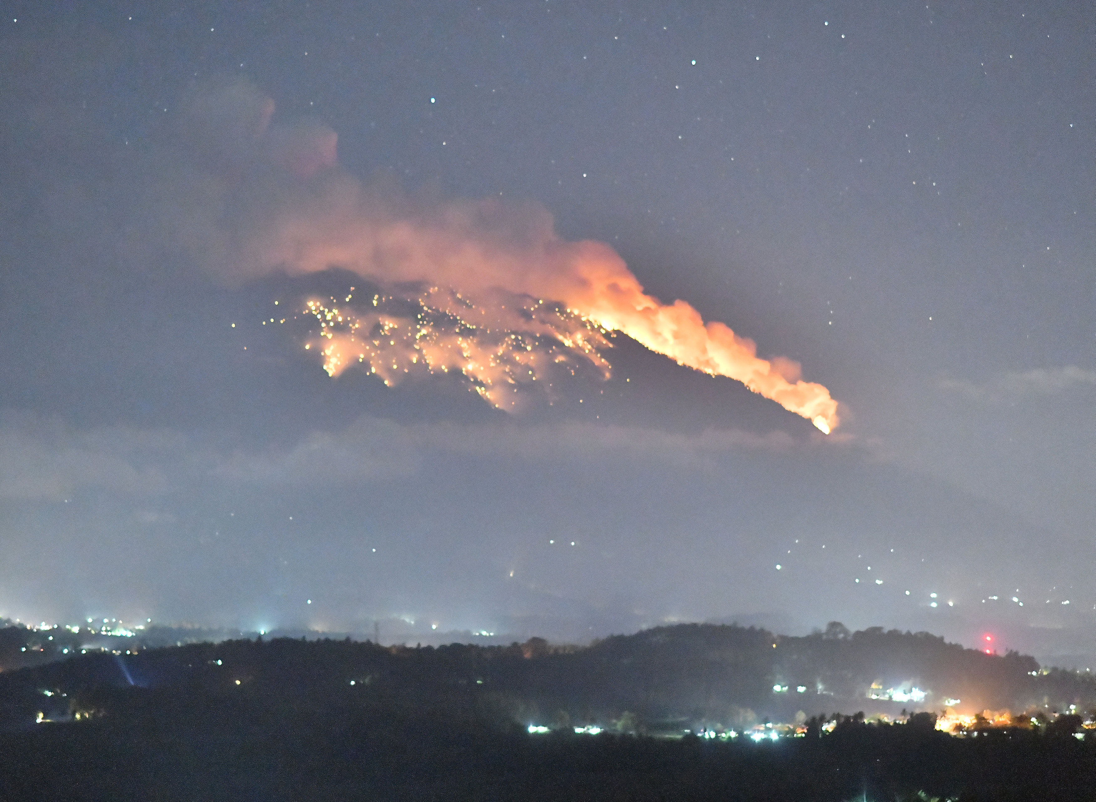
Agung towers over eastern Bali to a height of just over 3,000 meters (9,800 feet). Its last eruption in 1963 killed more than 1,000 people and razed several villages.

On Tuesday, however, life went on largely as normal in surrounding villages, with residents offering prayers as the volcano sent huge billows of ash and smoke into the sky.

Some villagers who fled in September, when the alert was last raised to the highest level, have gone home despite government warnings.

On Monday, authorities said 100,000 residents living near the volcano had been ordered to get out of an 8-10 km (5-6 mile) exclusion zone, warning a larger eruption was “imminent”.

While the population in the area has been estimated at anywhere between 63,000 and 140,000, just over 29,000 people were registered at emergency centers, said Sutopo Purwo Nugroho, a spokesman for the Disaster Mitigation Agency.

“Not all people in the danger zone are prepared to take refuge,” he said.

“There are still a lot of residents staying in their homes.”

Indonesia’s Volcanology and Geological Disaster Mitigation Center has warned that an eruption of a size similar to that seen in 1963 could send rocks bigger than a fist flying a distance of up to 8 km (5 miles), and volcanic gas a distance of 10 km (6 miles) within three minutes.

Monitoring has shown the northeastern part of Agung’s peak had swollen in recent weeks “indicating there is fairly strong pressure toward the surface”, the center said.

For interactive package on Agung eruptions, click: http://tmsnrt.rs/2hYdHiq

For graphic on the Pacific Ring of Fire, click: http://tmsnrt.rs/2BjtH6l

(Reporting by Kanupriya Kapoor, Slamet Kurniawan, Nyimas Laula and Reuters Bali stringer in BALI, and; Bernadette Christina Munthe, Cindy Silviana and Fransiska Nangoy in JAKARTA; Additional reporting by Angie Teo and Ed Davies; Writing by Fergus Jensen; Editing by Michael Perry, Robert Birsel)

Stranded Texans turn to social media for help as flood waters rise

Women are illuminated by the light of a smart phone as they seek refuge in the Good Samaritan Rescue Mission in Corpus Christi.

By Peter Szekely

(Reuters) – Flood-stranded Texans in the Houston area took to social media on Sunday with desperate pleas to be rescued from their homes as Tropical Storm Harvey and its torrential rains slowly lumbered across the region.

With authorities urging Houston’s more than 2 million residents to stay in their homes rather than risk venturing outside, some 70,000 of them formed a Facebook group that many of them used to call for help.

“Rescue needed!!” Lorena Martinez posted on the group, known “Hurricane Harvey 2017 – Together We Will Make It; TOGETHER WE WILL REBUILD.”

Martinez said 20 people, including six children, an elderly person and a pregnant woman, were stranded in a house on Houston’s Roper Street.

“Tried emergency service but not responding,” she said. “They’re in the attic with ax on hand if necessary.”

Many Houston residents reported being holed up in their attics, some with axes to chop their way out if necessary, even though emergency services advised people to climb onto the roofs to escape rising waters.

“Anyone in the area that can help… 4 adults 4 kids stuck in the attic.. no tools to break/cut into the roof,” said Carolyn Withrow Hutchins, who also posted a map with the location.

Emergency crews had rescued more than 1,000 stranded people from cars and homes in the Houston area by early Sunday.

Texas Governor Greg Abbott said the state was adding helicopters to those operated by officials in Houston and Harris County to help rescue stranded residents.

“Before today, the state had already made multiple water rescues from helicopters from dropped lines, and we are prepared to continue that process,” Abbott said on CNN’s “State of the Union” program.

Many residents posted that they were unable to reach emergency services by phone or were told that their rescues would take several hours.

Kathaleen Hervey was among many who turned to Twitter for help, saying a resident she knew needed to be rescued.

“He is trapped and can’t get through 911 or any of the emergency numbers, send a boat!!!” she tweeted to Houston Mayor Sylvester Turner.

Turner said emergency responders were giving their highest priority to the most flood-ravaged areas.

“911 is working,” Turner tweeted. “Every need is important. Please give preference to life-threatening situations.”


(Reporting by Peter Szekely in New York; Editing by Lisa Von Ahn)


Hundreds stranded in North Carolina floods after Hurricane Matthew

Men carry belongings from a neighbours home as flood waters rise after Hurricane Matthew in Lumberton, North Carolina,

By Judy Royal

CAROLINA BEACH, N.C. (Reuters) – Floodwaters left hundreds of people stranded in their homes and on rooftops in North Carolina early on Monday, and officials warned life-threatening flooding from swollen rivers would continue for days after Hurricane Matthew ravaged the southeastern United States.

Matthew, the most powerful Atlantic storm since 2007, was downgraded to a post-tropical cyclone on Sunday after its rampage through the Caribbean killed 1,000 people in Haiti.

In the United States, the death toll rose to at least 21 people with nearly half of the fatalities reported in North Carolina.

After receiving more than a foot (30 cm) of rain from Matthew during the weekend, skies were clear over North Carolina on Monday but the storm’s after-effects were creating major problems by overwhelming rivers and breaching levees.

“Hurricane Matthew is off the map, well into the ocean, but it still is right here in North Carolina,” Governor Pat McCrory said at a new conference on Monday. “This is an extremely dangerous situation.”

Ten people have died in the state, including a person killed after a car was driven into floodwaters and swept away in Johnston County on Sunday, McCrory said. With rivers rising, the governor said he expected the number of dead to increase.

Some 1,500 residents were stuck in their homes and on rooftops in Lumberton after an unexpected river levee breach Monday morning, McCrory said. Air and water rescues were underway in the city, where hundreds of people evacuated their homes overnight hours before the breach and floodwaters continued to rise quickly, he said.

McCrory said several other swollen rivers in the central and eastern parts of the state were expected to hit record levels and would crest throughout the week. Residents in several cities were urged to evacuate.

The National Weather Service said “life-threatening flooding” would continue on Monday over eastern portions of the state.

BREACHED DAMS

Many coastal and inland communities remained under water, either from coastal storm surge or overrun rivers and creeks.

All 2,000 residents of Princeville were told on Sunday to evacuate due to flash flood risks. The town lies on the Tar River about 25 miles (40 km) north of Greenville.

Several dams have breached in the area around Cumberland County, south of Raleigh, Michael Martin, fire marshal for the city of Fayetteville, said by phone.

Rescue teams still are on alert and there have been 1,400 people rescued. More than 600 National Guard troops were aiding in rescue and recovery efforts in the state.

In neighboring South Carolina, a vehicle trying to cross a flooded roadway in Florence County was swept away by floodwaters, killing one person, Governor Nikki Haley said on Sunday.

Jake Williams of Florence said on early Monday that his power had been out since Saturday morning.

“Trees are down in every neighborhood on almost every road,” he said. “I am no weather man but would guess that the gusts of wind were near 100 mph (160 km), and with soggy ground a lot trees couldn’t stand up to it.”

In Virginia Beach, the city said it had received more than 13 inches (33 cm) of rain and 55,000 people remained without power on Sunday night. The city said some 200 vehicles were abandoned and many roads remained impassable.

Norfolk, which declared a state of emergency, said efforts were underway to clear streets of debris and abandoned vehicles with city offices, libraries and recreational centers set to re-open Monday.

While power was being restored in some areas, 1.2 million people were without power in Florida, Georgia, North and South Carolina and Virginia, down from Sunday’s peak of 2.2 million.

Before the National Hurricane Center discontinued tropical storm warnings for Matthew, it was about 200 miles (320 km) off the coast of Cape Hatteras, North Carolina, and heading away from land as of late on Sunday.

The National Hurricane Center said on Monday morning that tropical storm Nicole was expected to strengthen into Tuesday. The storm was about 500 miles (800 km) south of Bermuda and moving northward toward the island.

The Atlantic hurricane season runs until Nov. 30.

(Writing by Timothy Mclaughlin and Laila Kearney; Editing by Colleen Jenkins and Bill Trott)