Punishing Hurricane Michael bears down on Florida Panhandle

Hurricane Michael is seen in this National Oceanic and Atmospheric Administrations's Geostationary Operational Environmental Satlellite (NOAA GOES-East satellite) image in the Gulf of Mexico, October 9, 2018. Courtesy NOAA GOES-East/Handout via REUTERS

By Devika Krishna Kumar

TALLAHASSEE, Fla. (Reuters) – Hurricane Michael was still strengthening as it closed in on the Florida Panhandle on Wednesday with the threat of catastrophic surges of sea water and roof-shredding winds, and was expected to be the worst hurricane ever recorded in the region.

Michael caught many by surprise with its rapid intensification as it churned north over the Gulf of Mexico. Shortly after 11 a.m. ET (1500 GMT) it was carrying top winds of 150 miles per hour (241 km per hour), making it a very dangerous Category 4 storm on five-step Saffir-Simpson scale, the National Hurricane Center said.

Authorities told residents along the affected areas of Florida’s northwest coast that they had run out of time to evacuate and should hunker down.

The storm caused major disruption to oil and gas production in the U.S. Gulf of Mexico.

Michael’s core was forecast to make landfall on Wednesday afternoon on Florida’s Panhandle and could drive sea water levels as high as 14 feet (4.3 meters) above normal in some areas, the hurricane center said. The storm could still strengthen further before coming ashore, it said.

As the outer bands arrived, ocean water was already flooding parts of Port St. Joe.

Mayor Bo Patterson said about 2,500 of the town’s 3,500 people were still there, including about 100 in a beachside area who did not follow a mandatory evacuation order. The two bridges leading out of Port St. Joe were closed, meaning no one could get out now.

“People are finally getting it, that this is going to be pretty strong,” Patterson said. “This happened so quickly, we weren’t exactly prepared.”

Michael grew from a tropical storm to Category 4 hurricane in about 40 hours.

“This kind of sprung up for us quite quickly,” said Andrew Gillum, mayor of the state capital, Tallahassee, which lies about 25 miles (40 km) from the coast and was preparing for a battering.

“We honestly felt we might have a tropical system and weren’t sure where it would go and now we’re staring down the barrel of a Category 4 storm,” Gillum told CNN.

“Satellite images of Michael’s evolution on Tuesday night were, in a word, jaw-dropping,” wrote Bob Henson, a meteorologist with weather site Weather Underground.

People in coastal parts of 20 Florida counties had been told to leave their homes. Much of the area is rural and known for small tourist cities, beaches and wildlife reserves, as well as Tallahassee.
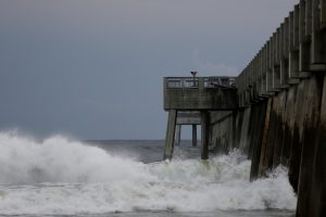
Waves crash along a pier as Hurricane Michael approaches Panama City Beach, Florida, U.S. October 9, 2018. REUTERS/Jonathan Bachman

Waves crash along a pier as Hurricane Michael approaches Panama City Beach, Florida, U.S. October 9, 2018. REUTERS/Jonathan Bachman

TOO LATE TO LEAVE

Governor Rick Scott said on Twitter on Wednesday morning that it was too late to evacuate the target zone and that people who had stayed should immediately seek refuge.

Hurricane center Director Ken Graham said on Facebook that Michael would be the worst storm in recorded history to hit the Panhandle.

“Going back through records to 1851 we can’t find another Cat 4 in this area, so this is unfortunately a historical and incredibly dangerous and life-threatening situation,” he said.

Nearly 40 percent of daily crude oil production and more than one-third of natural gas output was lost from offshore U.S. Gulf of Mexico wells on Wednesday because of platform evacuations and shut-ins caused by Michael.

The hurricane was about 60 miles (95 km) south-southwest of Panama City, Florida, and moving north-northeast at 14 mph (22 kph), the hurricane center said in its 11 a.m. ET advisory.

Apalachicola Mayor Van Johnson said his city, which could suffer some of the worst of the storm surge, was under mandatory evacuation orders.

“My greatest concern is that some people are just now starting to take this storm seriously and are evacuating,” he told CNN. “And I just hope the others that have not made that decision get out while the roads are still passable and before the bridges close.”

President Donald Trump declared a state of emergency for the entire state of Florida, freeing up federal assistance to supplement state and local disaster responses.

POWER CUTS START

Authorities warned of coming disruptions for those in Michael’s path. About 10,000 customers were already without power around midday.

The region should brace for “major infrastructure damage,” specifically to electricity distribution, wastewater treatment systems and transportation networks, Jeff Byard, associate administrator for the Federal Emergency Management Agency, told reporters on a conference call.

Many state offices, schools and universities in the area have been closed since Tuesday.

Helen Neal, 88, and her husband, J.W. Neal, 87, preferred to take their chances in a hotel rather than in their two-story beachfront house about a mile away in Panama City.

“We just finished renovating and updating,” she said. “We’re kind of nervous. God willing we’ll still have some place.”

About 2,500 National Guard troops were deployed to assist with evacuations and storm preparations, and more than 4,000 others were on standby. Some 17,000 utility restoration workers were also on call.

NHC Director Graham said Michael represented a “textbook case” of a hurricane system growing stronger as it drew near shore, in contrast to Hurricane Florence, which struck North Carolina last month after weakening in a slow, halting approach.

He said the storm would still have hurricane-force winds as it pushed through Florida into Georgia and tropical storm-force winds when it reaches the Carolinas, which are still reeling from post-Florence flooding. Up to a foot (30 cm) of rainfall was forecast for some areas.

Scott, a Republican running for the U.S. Senate in November’s congressional elections, declared a state of emergency in 35 Florida counties.

Georgia Governor Nathan Deal declared a state of emergency on Tuesday for 92 counties in his state and a state of emergency also was announced in North Carolina.

The last major hurricane, a storm of Category 3 or above, to hit the Panhandle was Dennis in 2005, according to hurricane center data.

(Reporting by Devika Krishna Kumar in Tallahassee, Florida; additional reporting by Rod Nickel in Panama City, Florida, Susan Heavey and Roberta Rampton in Washington, Gina Cherelus and Barbara Goldberg in New York, Brendan O’Brien in Milwaukee, Liz Hampton in Houston, Andrew Hay in New Mexico; Writing by Lisa Shumaker and Bill Trott; Editing by Frances Kerry)

Hurricane Florence nears Carolinas, forcing 1.5 million in westward exodus

Hurricane Florence is seen from the International Space Station as it churns in the Atlantic Ocean towards the east coast of the United States, September 10, 2018. NASA/Handout via REUTERS

By Anna Driver

HOLDEN BEACH, N.C. (Reuters) – More than 1.5 million people were ordered to evacuate their homes along the U.S. southeast coast as Hurricane Florence, the most powerful to menace the Carolinas in nearly three decades, barreled closer on Tuesday.

Florence, a Category 4 storm packing winds of 130 miles per hour (210 kph), was expected to make landfall on Friday, most likely in southeastern North Carolina near the South Carolina border, the National Hurricane Center in Miami said.

U.S. President Donald Trump on Tuesday signed declarations of emergency for both North Carolina and South Carolina, a step that frees up federal money and resources for storm response.

Empty shelves are seen at a supermarket as residents prepare for Storm Florence's descent in Columbia, South Carolina, U.S., September 10, 2018, in this still image taken from a video obtained from social media. @missgil/via REUTERS

Empty shelves are seen at a supermarket as residents prepare for Storm Florence’s descent in Columbia, South Carolina, U.S., September 10, 2018, in this still image taken from a video obtained from social media. @missgil/via REUTERS

Residents boarded up their homes and stripped grocery stores bare of food, water and supplies. The South Carolina Highway Patrol sent “flush cars” eastbound on major highways to clear traffic, before reversing lanes on major roadways to speed the evacuation of the coast, state officials said on Twitter.

South Carolina Governor Henry McMaster ordered about 1 million residents along his state’s coastline to leave starting at noon on Tuesday, when the highways will become westbound only. He evoked the memory of 1989’s Hurricane Hugo, which killed 27 people in the state, in urging people to comply.

“I’d rather be safe than sorry,” McMaster told ABC’s “Good Morning America” TV show on Tuesday. “We want people to get out and get safe.”

Virginia Governor Ralph Northam issued an evacuation order for about 245,000 residents in flood-prone coastal areas beginning at 8 a.m. local time.

GENERATOR, HOME REPAIR STOCKS UP

The storm was located about 950 miles (1,530 km) east-southeast of Cape Fear, North Carolina, at 8 a.m. ET, according to the NHC, which warned it would be “an extremely dangerous major hurricane” through Thursday night.

In addition to flooding the coast with wind-driven storm surges of seawater as high as 12 feet (3.7 m), Florence could drop 20 inches to as much as 30 inches (51 cm to 76 cm) of rain in places, posing the risk of deadly flooding miles inland, forecasters said. They warned the storm could linger for days after making landfall, drenching an already saturated landscape.

Shares of generator maker Generac Holdings Inc rose 3 percent, adding to Monday’s more than 5-percent gain, in expectation that the company will benefit from increased demand as the storm knocks out power for residents in the storm’s path.

Anticipating a rush for home protection and repair materials, investors also pushed up the shares of Home Depot Inc and Lowe’s Cos Inc for the second day.

STAY OR FLEE?

Customers line up to buy propane at Socastee Hardware store, ahead of the arrival of Hurricane Florence in Myrtle Beach, South Carolina, U.S. September 10, 2018. REUTERS/Randall Hill

Customers line up to buy propane at Socastee Hardware store, ahead of the arrival of Hurricane Florence in Myrtle Beach, South Carolina, U.S. September 10, 2018. REUTERS/Randall Hill

At least 250,000 more people were due to be evacuated from the northern Outer Banks in North Carolina on Tuesday after more than 50,000 people were ordered on Monday to leave Hatteras and Ocracoke, the southernmost of the state’s barrier islands.

“We haven’t plywooded our house for several years but I am for this one,” said Tom Pahl, 66, by phone from Ocracoke Island. Pahl, who serves as a Hyde County commissioner, said he had not yet made up his mind about leaving the island, which is reachable only by ferry and plane.

Retired Maryland State Police pilot Paul Jones and his wife hit the road early on Tuesday to avoid traffic from Hatteras Island to their Maryland residence.

“I will not stay for a hurricane,” Jones, 68, said. “I have had enough excitement in my life.”

Classified as a Category 4 on the five-step Saffir-Simpson scale of hurricane strength, Florence is the most severe storm to threaten the U.S. mainland this year.

The United States was hit with a series of high-powered hurricanes last year, including Hurricane Maria, which killed some 3,000 people in Puerto Rico, and Hurricane Harvey, which killed about 68 people and caused an estimated $1.25 billion in damage with catastrophic flooding in Houston.

(Additional reporting by Gene Cherry in Raleigh, North Carolina, Susan Heavey in Washington and Brendan O’Brien in Milwaukee; Writing by Nick Zieminski; Editing by Scott Malone and Bill Rigby)

Japan’s heat wave drives up food prices, prison inmate dies

A woman uses a parasol on the street during a heatwave in Tokyo, Japan July 25, 2018. REUTERS/Kim Kyung-Hoon

TOKYO (Reuters) – Vegetable prices in Japan are spiking as much as 65 percent in the grip of a grueling heat wave, which drove temperatures on Wednesday to records in some areas hit by flooding and landslides, hampering clean-up and recovery efforts.

As many as 65 people died in the week to July 22, up from 12 the previous week, government figures show, while a prisoner in his forties died of a heat stroke in central Miyoshi city, amid what medical experts called an “unprecedented” heat wave.

An agriculture ministry official in Tokyo, the capital, warned against “pretty severe price moves” for vegetables if predictions of more weeks of hot weather held up, resulting in less rain than usual.

“It’s up to the weather how prices will move from here,” the official said. “But the Japan Meteorological Agency has predicted it will remain hot for a few more weeks, and that we will have less rain than the average.”

The most recent data showed the wholesale price of cabbage was 129 yen ($1.16) per kg in Tokyo on Monday, the ministry said, for example, an increase of 65 percent over the average late-July price of the past five years.

Temperatures in Japan’s western cities of Yamaguchi and Akiotacho reached record highs of 38.8 Celsius (101.8 Fahrenheit) and 38.6 C (101.5 F), respectively, on Wednesday afternoon.

In Takahashi, another western city and one of the areas hit hardest by this month’s flooding, the mercury reached 38.7 C (101.7 F), just 0.3 degrees off an all-time high.

In Miyoshi, where the prisoner died after a heat stroke, the temperature on the floor of his cell was 34 degrees C (93 F) shortly before 7 a.m. on Tuesday. The room had no air-conditioning, like most in the prison.

Authorities who found him unresponsive in his cell sent him to a hospital outside the prison, but he was soon pronounced dead, a prison official said.

“It is truly regrettable that an inmate lost his life,” Kiyoshi Kageyama, head of the prison, said in a statement. “We will do our utmost in maintaining (prisoners’) health, including taking anti-heat stroke steps.”

On the Tokyo stock market, shares in companies expected to benefit from a hot summer, such as ice-cream makers, have risen in recent trade.

Shares in Imuraya Group, whose subsidiary sells popular vanilla and red-bean ice cream, were up nearly 10 percent on the month, while Ishigaki Foods, which sells barley tea, surged 50 percent over the same period.

Kimono-clad women using sun umbrellas pause on a street during a heatwave in Tokyo, Japan July 25, 2018. REUTERS/Issei Kato

Kimono-clad women using sun umbrellas pause on a street during a heatwave in Tokyo, Japan July 25, 2018. REUTERS/Issei Kato

In neighboring South Korea, the unremitting heat has killed at least 14 people this year, the Korea Centers for Diseases Control and Prevention said.

The heat wave was at the level of a “special disaster”, South Korean President Moon Jae-in said on Tuesday, as electricity use surged and vegetable prices rose.

(Reporting by Kiyoshi Takenaka in Tokyo and Jeongmin Kim in SEOUL; Additional reporting by Ritsuko Ando and Aaron Sheldrick in TOKYO; Editing by Clarence Fernandez)

Yemen’s cholera epidemic likely to intensify in coming months: WHO

FILE PHOTO: A nurse walks by women being treated at a cholera treatment center in the Red Sea port city of Hodeidah, Yemen October 8, 2017. REUTERS/Abduljabbar Zeyad

RIYADH (Reuters) – The World Health Organization warned on Monday that a cholera epidemic in Yemen that killed more than 2,000 people could flare up again in the rainy season.

WHO Deputy Director General for Emergency Preparedness and Response Peter Salama said the number of cholera infections had been in decline in Yemen over the past 20 weeks after it hit the 1 million mark of suspected cases.

“However, the real problem is we’re entering another phase of rainy seasons,” Salama told Reuters on the sidelines of an international aid conference in Riyadh.

“Usually cholera cases increase corresponding to those rainy seasons. So we expect one surge in April, and another potential surge in August.”

A proxy war between Iran-aligned Houthis and the internationally recognized government of President Abd-Rabbu Mansour Hadi, which is backed by a Saudi-led alliance, has killed more than 10,000 people since 2015, displaced more than 2 million and destroyed much of the country’s infrastructure, including the health system.

Yemen relies heavily on food imports and is on the brink of famine. The United Nations says more than 22 million of Yemen’s 25 million population need humanitarian assistance, including 11.3 million who are in acute need.

Salama said the country had also had an outbreak of diphtheria, a vaccine-preventable disease that usually affects children and which has largely been eliminated in developed countries.

Both cholera and diphtheria outbreaks are a product of the damage to the health system in the country, he said, adding that less than half of Yemen’s health facilities are fully functioning.

“We’re very concerned we’re going to go from a failing health system to a failed one that’s going to spawn more infectious diseases and more suffering,” Salama said.

However, Salama said that despite more than 2,000 deaths from cholera, the fatality rate has been low, at around 0.2 to 0.3 percent.

The WHO has approval from the government for vaccination campaigns and is working on ensuring all parties to the conflict implement the plan, he added.

(Reporting by Sarah Dadouch; Editing by Alison Williams)

United Passenger jet lands in Hawaii after engine covering rips apart

The plane with engine problems is seen on the tarmac in Honolulu, Hawaii, U.S., February 13, 2018 in this picture obtained from social media. Peter Lemme/via REUTERS

(Reuters) – Passengers aboard a United Airlines flight from San Francisco to Honolulu had a scary trip over the Pacific Ocean on Tuesday, after the casing around one of the engines ripped apart, officials said.

The plane with engine problems is seen on the tarmac in Honolulu, Hawaii, U.S., February 13, 2018 in this picture obtained from social media. Mariah Amerine/via REUTERS

The plane with engine problems is seen on the tarmac in Honolulu, Hawaii, U.S., February 13, 2018 in this picture obtained from social media. Mariah Amerine/via REUTERS

United flight 1175, with more than 370 people on board including crew members, landed without incident at Honolulu International Airport, United Airlines Inc spokesman Charles Hobart said in an email.

Passengers brace during the plane landing in Honolulu, Hawaii, U.S., February 13, 2018 in this still image taken from a social media video. Mariah Amerine/via REUTERS

Passengers brace during the plane landing in Honolulu, Hawaii, U.S., February 13, 2018 in this still image taken from a social media video. Mariah Amerine/via REUTERS

“Scariest flight of my life,” Maria Falaschi, a marketing consultant from San Francisco, wrote on Twitter. She posted photos on the social media website of the aircraft’s engine with its covering, also known as the cowling, missing.

Hobart said he could not immediately say whether or not the engine on the Boeing 777 continued to function after the cowling came off.

The pilots of United flight 1175 declared an emergency due to a vibration in the right engine before the plane landed safely, Federal Aviation Administration (FAA) spokesman Ian Gregor said in an email. The FAA will investigate the incident.

(Reporting by Alex Dobuzinskis in Los Angeles)

Philippine province declares ‘calamity’ as volcano lava spreads

Clouds partially cover Mayon volcano's crater as it spews a column of ash during another mild eruption in Legazpi City, Albay province, south of Manila, Philippines January 16, 2018.

MANILA (Reuters) – A central Philippine province declared a state of calamity on Tuesday as a volcano spewed lava that reached the limits of a six-km radius no-go zone and spread ash on nearby farming villages.

Mount Mayon, a volcano in Albay province in the coconut-growing central Bicol region, has been erupting since Saturday and the number of people fleeing their homes had more than doubled on Tuesday to about 25,000, said Albay Governor Al Francis Bichara.

The National Disaster Risk Reduction and Management Council gave a smaller estimate, saying there were close to 22,000 evacuees.

Placing the province under a state of calamity will give the province access to extra funds.

“This kind of eruption, it will take about weeks, so we have to sustain the operations in the evacuation centers,” Bichara told ANC news channel. “We need to use the calamity funds.”

The Philippine Institute of Volcanology and Seismology (Phivolcs) said it had recorded nine more tremors, four of which accompanied lava fountains, as pressure leads to lava flows and ash plumes.

It reiterated that the activity signified a possible hazardous eruption within weeks or even days from the near perfectly cone-shaped volcano.

The provincial government has also expanded its suspension of school classes to more towns around the 2,462-metre (8,077-foot) volcano, about 340 km (210 miles) southeast of Manila.

Class suspensions have allowed the government to use schools as temporary shelters.

(Reporting by Enrico dela Cruz; Editing by Martin Petty and Nick Macfie)

People evacuated from Papua New Guinea island after volcano explodes

The remote island volcano of Kadovar spews ash into the sky in Papua New Guinea, January 6, 2018. SAMARITAN AVIATION/via REUTERS

By Alison Bevege

SYDNEY (Reuters) – About 1,500 people are being evacuated from an island off the northern coast of Papua New Guinea (PNG) after a nearby volcano erupted, the local Red Cross said on Sunday.

A volcano on the island of Kadovar, located about 24 km (15 miles) north of the Papuan mainland, began erupting on Jan. 5. That prompted the evacuation of 590 people on Kadovar to the nearby island of Blup Blup.

After venting ash for several days, the volcano exploded on Friday, blasting out glowing red rocks and sulphur dioxide, the Rabaul Volcanological Observatory said in a bulletin. The PNG government then decided to evacuate Blup Blup as well because of issues with supplying people on the island along with the danger from the eruption.

The evacuees are being moved to the mainland and the International Red Cross is providing about 87,000 kina ($26,274) in funding to help them, said PNG Red Cross Secretary General Uvenama Rova by telephone from the capital of Port Moresby.

“The people there, as the volcano erupted, they rushed immediately to escape. So they are in immediate need of food, water, shelter and clothing as well,” he said.

In the latest bulletin issued on Sunday, the Observatory said a dome of lava on Kadover was visible in the sea at the base of thick white steam clouds that are rising to 600 meters (1,969 feet) above sea level.

Australia’s Foreign Minister Julie Bishop announced on twitter that the Australian Government was contributing A$25,000 ($19,775) worth of humanitarian supplies for those affected.

There are no confirmed records of a previous eruption of Kadovar, said Chris Firth, a vulcanologist at Macquarie University, but scientists speculate it could have been one of two “burning islands” mentioned in the journals of a 17th-century English pirate and maritime adventurer, William Dampier.

(Reporting by Alison Bevege; Editing by Christian Schmollinger)

California wildfire fight aided by better weather

California wildfire fight aided by better weather

By Steve Gorman

LOS ANGELES (Reuters) – Thousands of weary firefighters, battling a deadly 2-week-old California wildfire that ranks as the third largest in state history, welcomed a second straight day of favorable weather on Monday that allowed a more aggressive attack on the flames.

The so-called Thomas fire has scorched 271,000 acres (110,000 hectares) of drought-parched chaparral and brush in the coastal mountains, foothills and canyons of Ventura and Santa Barbara counties northwest of Los Angeles.

The burned zone encompasses an area about a third of the size of the state of Rhode Island.

More than 1,000 homes and other buildings have gone up in flames and some 18,000 other structures remained threatened from a late-season firestorm that kept firefighters on the defensive for the better part of two weeks.

One firefighter lost his life, succumbing to smoke inhalation and burns last Thursday near the town of Fillmore in Ventura County.

A mix of lighter winds, rising humidity and cooler air temperatures prevailed for a second day on Monday, affording crews the greatest weather break they had seen yet, said Lynne Tolmachoff, a spokeswoman for the California Department of Forestry and Fire Protection (CalFire).

“Everybody is breathing a sigh of relief that this will give those firefighters a chance to get in there and do some good work, and not just be constantly chasing things,” she told Reuters by telephone.

A firefighting force of 8,500 personnel had carved containment lines around 50 percent of the blaze’s perimeter as of Monday night, up from 45 percent earlier.

But coastal communities within the towns of Santa Barbara, Montecito and Summerland were still at risk as crews hurried to extend and shore up buffer zones before a return of higher winds forecast for Wednesday, Tolmachoff said. Full containment is not expected before the second week of January.

The blaze erupted on Dec. 4 and was stoked by hot, dry Santa Ana winds blowing with rare hurricane force from the high desert to the east, spreading the flames across miles of rugged coastal terrain faster than firefighters could keep up.

The latest tally of burned landscape puts the Thomas blaze among the three largest wildfires documented in California, approaching the record size of the 2003 Cedar fire in San Diego County that consumed 273,246 acres (110,600 hectares) and killed 15 people.

The Thomas fire has displaced more than 100,000 people, although authorities in Santa Barbara County lifted evacuation orders for additional areas no longer considered to be in harm’s way, and more communities were to be reopened on Tuesday.

CalFire has put the estimated cost of fighting the blaze at nearly $131 million. The cause remained under investigation.

The Thomas came two months after a spate of wind-driven blazes in Northern California’s wine country incinerated several thousand homes and killed more than 40 people, ranking as the deadliest rash of wildfires, and one of the most destructive, in state history.

(Additional reporrting by Chris Kenning in Chicago and Peter Szekely in New York; Editing by Clive McKeef and Peter Cooney)

Vicious winds to test crews battling California wildfire

Vicious winds to test crews battling California wildfire

By Dan Whitcomb

LOS ANGELES (Reuters) – Firefighters in California will be tested by vicious winds on Friday morning as they battle a huge wildfire that has claimed the life of one of their colleagues and torched more than 700 homes.

Cory Iverson, 32, a California Department of Forestry and Fire Protection engineer, was killed on Thursday while tackling the so-called Thomas Fire in Ventura and Santa Barbara counties.

“Cory Iverson … made the ultimate sacrifice to save the lives of others,” said Ventura County Sheriff Geoff Dean during a community meeting on Thursday night.

Fire officials released little information about the circumstances surrounding Iverson’s death. The Los Angeles Daily News reported that he perished in an accident near the community of Fillmore, where a mayday alert was sounded.

Santa Ana winds and humidity in the single digits has helped stoke the blaze that has swept through dry vegetation since it erupted on Dec. 4 near a small private college in Ojai. It has since blackened more than 249,000 acres (about 390 square miles, or 1,000 sq km) and is now the fourth-largest wildfire on record in California since 1932.

On Friday morning powerful winds are forecast which will subside during the day, the National Weather Service said.

“Winds will weaken Friday, turn westerly early Saturday, then become offshore and gusty again late Saturday night through Sunday evening,” the service said in an advisory.

The wildfire remained a threat to some 18,000 homes and other structures in the communities of Santa Barbara, Carpinteria, Summerland and Montecito along California’s coastline, especially if hot, dry Santa Ana winds return.

The Thomas Fire, which was 35 percent contained as of Thursday evening, has burned 729 homes to the ground and damaged another 175. The blaze has displaced more than 94,000 people.

The fire and others to the south in San Diego and Los Angeles counties have disrupted life for millions of people over the last 11 days.

They have caused schools to close for days, shut roads and driven hundreds of thousands from their homes and into shelters. The fires are also responsible for poor air quality throughout Southern California, forcing some commuters to wear protective face masks, local media reported.

(Additional reporting by Brendan O’Brien in Milwaukee; editing by Andrew Roche)

After fires, Southern California faces risk of mudslides

After fires, Southern California faces risk of mudslides

By Ben Gruber and Alex Dobuzinskis

CARPINTERIA, Calif./LOS ANGELES (Reuters) – Firefighters in Southern California are slowly gaining control of one of the largest wildfires in state history, but residents may not enjoy much relief as experts said the flames are laying the groundwork for the next disaster – mudslides.

The intense fire is burning away vegetation that holds the soil in place and baking a waxy layer into the earth that prevents the water from sinking more than a few inches into the ground, experts said.

With one heavy rain, the soil above this waterproof layer can become saturated, start to slide in hilly areas and transform into something catastrophic.

“Pretty much anywhere there’s a fire on a steep slope, there’s cause for concern,” Jason Kean, research hydrologist for the U.S. Geological Survey, said in a telephone interview.

And the Thomas Fire, which has burned 234,000 acres and destroyed nearly 700 homes in Ventura and Santa Barbara counties, is definitely in landslide country.

“If we get hard rain, there are going to be terrible landslides in the burn areas,” Carla D’Antonio, chairman of University of California, Santa Barbara’s environmental studies program, said in an email.

“It doesn’t take a lot of rain to get the soil and rock moving, so to have burned soil on top of this and no significant plant cover creates huge potential for landslides,” she added.

Among the cities at risk is Santa Barbara, with 92,000 people, as well as the smaller communities of Carpinteria, Ojai and Summerland.

“It’s terrifying,” Jamey Geston, 19, of Carpinteria, said of possible mudslides. “I am just taking it one natural disaster at a time at this point and try to get through it.”

Once the fire is out, more work will begin as officials will likely need to rush to build retention basins and other structures to prevent debris flows before the rainy season begins, said Professor Nicholas Pinter of University of California, Davis’ Department of Earth and Planetary Sciences.

“This is exactly the thing we worry about in the winter following an event like the Thomas Fire,” he said by telephone.

Another large concern is the potential damage to water quality, Santa Barbara Mayor Helene Schneider said in a telephone interview.

Heavy rainfall could bring lots of silt to waterways like Lake Cachuma, where barriers are already being erected, as well as unwanted matter, she said. In 2007, after the massive Zaca Fire, Santa Barbara spent more than $1 million on extra cleaning and filtration systems.

The Federal Emergency Management Agency and the state could defray some costs with grants, but the best outcome would be “a nice, calm, intermittent rain,” Schneider said.

“We don’t see any rain in the immediate forecast, which is a curse and a blessing,” she said. “We could use the water to fight the fire, but we don’t want some kind of big downpour that would cause significant mudslides so soon after the area’s been burnt to nothing.”

(Reporting by Ben Gruber and Alex Dobuzinskis, Writing by Ben Klayman; Editing by Cynthia Osterman)