
By Devika Krishna Kumar
TALLAHASSEE, Fla. (Reuters) – Hurricane Michael was still strengthening as it closed in on the Florida Panhandle on Wednesday with the threat of catastrophic surges of sea water and roof-shredding winds, and was expected to be the worst hurricane ever recorded in the region.
Michael caught many by surprise with its rapid intensification as it churned north over the Gulf of Mexico. Shortly after 11 a.m. ET (1500 GMT) it was carrying top winds of 150 miles per hour (241 km per hour), making it a very dangerous Category 4 storm on five-step Saffir-Simpson scale, the National Hurricane Center said.
Authorities told residents along the affected areas of Florida’s northwest coast that they had run out of time to evacuate and should hunker down.
The storm caused major disruption to oil and gas production in the U.S. Gulf of Mexico.
Michael’s core was forecast to make landfall on Wednesday afternoon on Florida’s Panhandle and could drive sea water levels as high as 14 feet (4.3 meters) above normal in some areas, the hurricane center said. The storm could still strengthen further before coming ashore, it said.
As the outer bands arrived, ocean water was already flooding parts of Port St. Joe.
Mayor Bo Patterson said about 2,500 of the town’s 3,500 people were still there, including about 100 in a beachside area who did not follow a mandatory evacuation order. The two bridges leading out of Port St. Joe were closed, meaning no one could get out now.
“People are finally getting it, that this is going to be pretty strong,” Patterson said. “This happened so quickly, we weren’t exactly prepared.”
Michael grew from a tropical storm to Category 4 hurricane in about 40 hours.
“This kind of sprung up for us quite quickly,” said Andrew Gillum, mayor of the state capital, Tallahassee, which lies about 25 miles (40 km) from the coast and was preparing for a battering.
“We honestly felt we might have a tropical system and weren’t sure where it would go and now we’re staring down the barrel of a Category 4 storm,” Gillum told CNN.
“Satellite images of Michael’s evolution on Tuesday night were, in a word, jaw-dropping,” wrote Bob Henson, a meteorologist with weather site Weather Underground.
People in coastal parts of 20 Florida counties had been told to leave their homes. Much of the area is rural and known for small tourist cities, beaches and wildlife reserves, as well as Tallahassee.
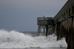
Waves crash along a pier as Hurricane Michael approaches Panama City Beach, Florida, U.S. October 9, 2018. REUTERS/Jonathan Bachman
TOO LATE TO LEAVE
Governor Rick Scott said on Twitter on Wednesday morning that it was too late to evacuate the target zone and that people who had stayed should immediately seek refuge.
Hurricane center Director Ken Graham said on Facebook that Michael would be the worst storm in recorded history to hit the Panhandle.
“Going back through records to 1851 we can’t find another Cat 4 in this area, so this is unfortunately a historical and incredibly dangerous and life-threatening situation,” he said.
Nearly 40 percent of daily crude oil production and more than one-third of natural gas output was lost from offshore U.S. Gulf of Mexico wells on Wednesday because of platform evacuations and shut-ins caused by Michael.
The hurricane was about 60 miles (95 km) south-southwest of Panama City, Florida, and moving north-northeast at 14 mph (22 kph), the hurricane center said in its 11 a.m. ET advisory.
Apalachicola Mayor Van Johnson said his city, which could suffer some of the worst of the storm surge, was under mandatory evacuation orders.
“My greatest concern is that some people are just now starting to take this storm seriously and are evacuating,” he told CNN. “And I just hope the others that have not made that decision get out while the roads are still passable and before the bridges close.”
President Donald Trump declared a state of emergency for the entire state of Florida, freeing up federal assistance to supplement state and local disaster responses.
POWER CUTS START
Authorities warned of coming disruptions for those in Michael’s path. About 10,000 customers were already without power around midday.
The region should brace for “major infrastructure damage,” specifically to electricity distribution, wastewater treatment systems and transportation networks, Jeff Byard, associate administrator for the Federal Emergency Management Agency, told reporters on a conference call.
Many state offices, schools and universities in the area have been closed since Tuesday.
Helen Neal, 88, and her husband, J.W. Neal, 87, preferred to take their chances in a hotel rather than in their two-story beachfront house about a mile away in Panama City.
“We just finished renovating and updating,” she said. “We’re kind of nervous. God willing we’ll still have some place.”
About 2,500 National Guard troops were deployed to assist with evacuations and storm preparations, and more than 4,000 others were on standby. Some 17,000 utility restoration workers were also on call.
NHC Director Graham said Michael represented a “textbook case” of a hurricane system growing stronger as it drew near shore, in contrast to Hurricane Florence, which struck North Carolina last month after weakening in a slow, halting approach.
He said the storm would still have hurricane-force winds as it pushed through Florida into Georgia and tropical storm-force winds when it reaches the Carolinas, which are still reeling from post-Florence flooding. Up to a foot (30 cm) of rainfall was forecast for some areas.
Scott, a Republican running for the U.S. Senate in November’s congressional elections, declared a state of emergency in 35 Florida counties.
Georgia Governor Nathan Deal declared a state of emergency on Tuesday for 92 counties in his state and a state of emergency also was announced in North Carolina.
The last major hurricane, a storm of Category 3 or above, to hit the Panhandle was Dennis in 2005, according to hurricane center data.
(Reporting by Devika Krishna Kumar in Tallahassee, Florida; additional reporting by Rod Nickel in Panama City, Florida, Susan Heavey and Roberta Rampton in Washington, Gina Cherelus and Barbara Goldberg in New York, Brendan O’Brien in Milwaukee, Liz Hampton in Houston, Andrew Hay in New Mexico; Writing by Lisa Shumaker and Bill Trott; Editing by Frances Kerry)


