Mudslide risk in Southern California wildfire zones prompts evacuation of thousands

Mud flows along a beach in Malibu, California, U.S., December 6, 2018, in this still image taken from a video obtained from social media. Mike Gardner/via REUTERS

By Alex Dobuzinskis

LOS ANGELES (Reuters) – Heavy rains and the threat of mudslides in Southern California forced the closure of a key coastal highway near Malibu on Thursday and prompted authorities to order evacuations of almost 3,000 residents from hillside areas scarred by recent wildfires.

The same Pacific storm also brought snow to the region’s high country, leading to the temporary closure of a stretch of Interstate 5 called the Grapevine, a major truck route that traverses a mountain pass north of Los Angeles, officials said.

The storm, which led the National Weather Service to issue flash-flood warnings for parts of Southern California, heightened concerns about the long-term risk of mudslides and debris flows around communities where wildfires have stripped foothills and canyon slopes of vegetation.

Last month, the Woolsey Fire incinerated 1,500 buildings and charred 97,000 acres (39,000 hectares) in the upscale coastal enclave of Malibu and adjacent areas near Los Angeles, leaving large swaths of hilly landscape vulnerable to slides and flooding.

“The fires have generated some risks that we need to be aware of and be cautious of for several years into the future,” Cindy Matthews, a senior National Weather Service hydrologist, said.

About 2,700 people were ordered evacuated from Lake Elsinore and surrounding Riverside County communities about 60 miles (100 km) east of Los Angeles, where rains threatened to unleash rivers of mud, boulders and other debris down hillsides, according to California Department of Forestry and Fire Protection (Cal Fire) Captain Fernando Herrera.

Some mudflows occurred on Thursday in the area, burned earlier this year by the Holy fire, but no major property damage was reported, Herrera said.

The threat of mudslides in the Woolsey Fire zone around Malibu was not deemed severe enough to trigger evacuations there, Los Angeles County Fire Department spokesman Tony Imbrenda said.

However, as a heavy debris flow smothered a nearby section of Pacific Coast Highway, forcing authorities to close that stretch of the scenic highway for a few hours.

In all, the storm dumped more than 3 inches (8 cm) of rain in some parts of Southern California, according to the National Weather Service.

(Reporting by Alex Dobuzinskis, Editing by Steve Gorman and Lisa Shumaker)

Parts of ravaged Paradise open for first time since California wildfire

FILE PHOTO: Deer are seen on a property damaged by the Camp Fire in Paradise, California, U.S. November 21, 2018. REUTERS/Elijah Nouvelage/File Photo

By Saif Tawfeeq

PARADISE, Calif. (Reuters) – Thousands of Paradise residents who fled a monster blaze a month ago were allowed on Wednesday to return to some neighborhoods in the Northern California city nearly obliterated by one of the deadliest wildfires in U.S. history.

Tim Moniz, a rice farmer, and welder in his 50s, personally surveyed the remains of his Paradise property for the first time since the fire, confirming his suspicions that his house was gone. He and his wife only recently paid off the mortgage.

“It seems unfair that some houses make it and yours don’t,” Moniz said. “I just had to get back up and see it and try to salvage something.”

Paradise residents who return to their ravaged homes will face a daunting task to resume normal life, with some likely to encounter months or even years of work to obtain compensation for their losses and rebuild.

Authorities hurriedly evacuated some 50,000 people in Paradise and neighboring towns when the Camp Fire erupted on Nov. 8. The fire killed at least 85 people with nearly a dozen still unaccounted for. It also destroyed nearly 14,000 homes in the wooded, foothill communities.

Evacuation orders were previously lifted in areas outside Paradise, but Wednesday marked the first day officials opened parts of the city itself in the midst of the fire’s scorched wasteland of 153,000 acres (61,900 hectares).

REBUILDING A RESHAPED TOWN

Moniz said he is among those planning to rebuild, rather than move away.

But the fire’s devastation will reshape the town and – at least initially – lower its population, Paradise Mayor Jody Jones said by telephone.

“All my friends who are in their 80s, they’re just not going to go through this process of rebuilding,” Jones said, adding she believes three-quarters of Paradise residents will rebuild.

Some residents may be able to salvage jewelry or even stuff such as intact tool boxes from the rubble of their houses, said Jones, who lost her own home in the fire.

Some residents rumbled back into town in recreational vehicles, apparently planning to spend the night, Paradise Police Chief Eric Reinbold said by phone.

Authorities said they will let some residents stay overnight on their properties, but advise against it because electricity, gas and other services were not available.

Paradise’s skyline is dotted with 30 large cranes that crews are using to remove debris, said city spokesman Matt Gates.

Health and safety specialists are sweeping through Paradise to remove batteries, propane tanks, household chemicals and other environmental hazards in the aftermath of the fire, Gates said. Residents entering the re-opened areas of town were offered gear to protect themselves from hazardous materials, Reinbold said.

Full removal of debris could take nine months, Jones said.

(Reporting by Saif Tawfeeq; Additional reporting and writing by Alex Dobuzinskis in Los Angeles; editing by Bill Tarrant and Lisa Shumaker)

Thousands evacuated as Guatemala’s Fuego volcano erupts

Steam rises from Fuego volcano (Volcano of Fire) as seen from San Juan Alotenango, outside of Guatemala City, Guatemala November 19, 2018. REUTERS/Luis Echeverria

GUATEMALA CITY (Reuters) – Nearly 4,000 people were evacuated on Monday from areas around Guatemala’s Fuego volcano, which began violently erupting overnight, the country’s disaster agency Conred said.

The volcano spewed out dangerous flows of fast-moving clouds of hot ash, lava and gas early Monday and more than 2,000 people had taken refuge in shelters so far, officials from the agency told reporters. There were no immediate reports of injuries.

A general view shows Fuego volcano (Volcano of Fire) erupting as seen from San Juan Alotenango, outside of Guatemala City, Guatemala November 19, 2018. REUTERS/Luis Echeverria

A general view shows Fuego volcano (Volcano of Fire) erupting as seen from San Juan Alotenango, outside of Guatemala City, Guatemala November 19, 2018. REUTERS/Luis Echeverria

More dangerous flows of hot ash and lava could be expelled, said Juan Pablo Oliva, the head of the country’s seismological, volcanic and meteorological institute Insivumeh.

In June, explosive flows from Fuego killed more than 190 people.

This is the fifth eruption so far this year of the 3,763-meter (12,346-feet) volcano, one of the most active in Central America, about 19 miles (30 km) south of Guatemala City.

(Reporting by Enrique Garcia; Editing by David Gregorio)

Thousands evacuated as Guatemala’s Fuego volcano erupts

A general view shows Fuego volcano (Volcano of Fire) erupting as seen from San Juan Alotenango, outside of Guatemala City, Guatemala November 19, 2018. REUTERS/Luis Echeverria

GUATEMALA CITY (Reuters) – Nearly 4,000 people were evacuated on Monday from areas around Guatemala’s Fuego volcano, which began violently erupting overnight, the country’s disaster agency Conred said.

The volcano spewed out dangerous flows of fast-moving clouds of hot ash, lava and gas early Monday and more than 2,000 people had taken refuge in shelters so far, officials from the agency told reporters. There were no immediate reports of injuries.

More dangerous flows of hot ash and lava could be expelled, said Juan Pablo Oliva, the head of the country’s seismological, volcanic and meteorological institute Insivumeh.

In June, explosive flows from Fuego killed more than 190 people.

This is the fifth eruption so far this year of the 3,763-meter (12,346-feet) volcano, one of the most active in Central America, about 19 miles (30 km) south of Guatemala City.

(Reporting by Enrique Garcia; Editing by David Gregorio)

Deadly California wildfire grows as teams sift through ashes for remains

A volunteer search and rescue crew from Calaveras County comb through a home destroyed by the Camp Fire in Paradise, California, U.S., November 13, 2018. REUTERS/Terray Sylvester

By Noel Randewich and Sharon Bernstein

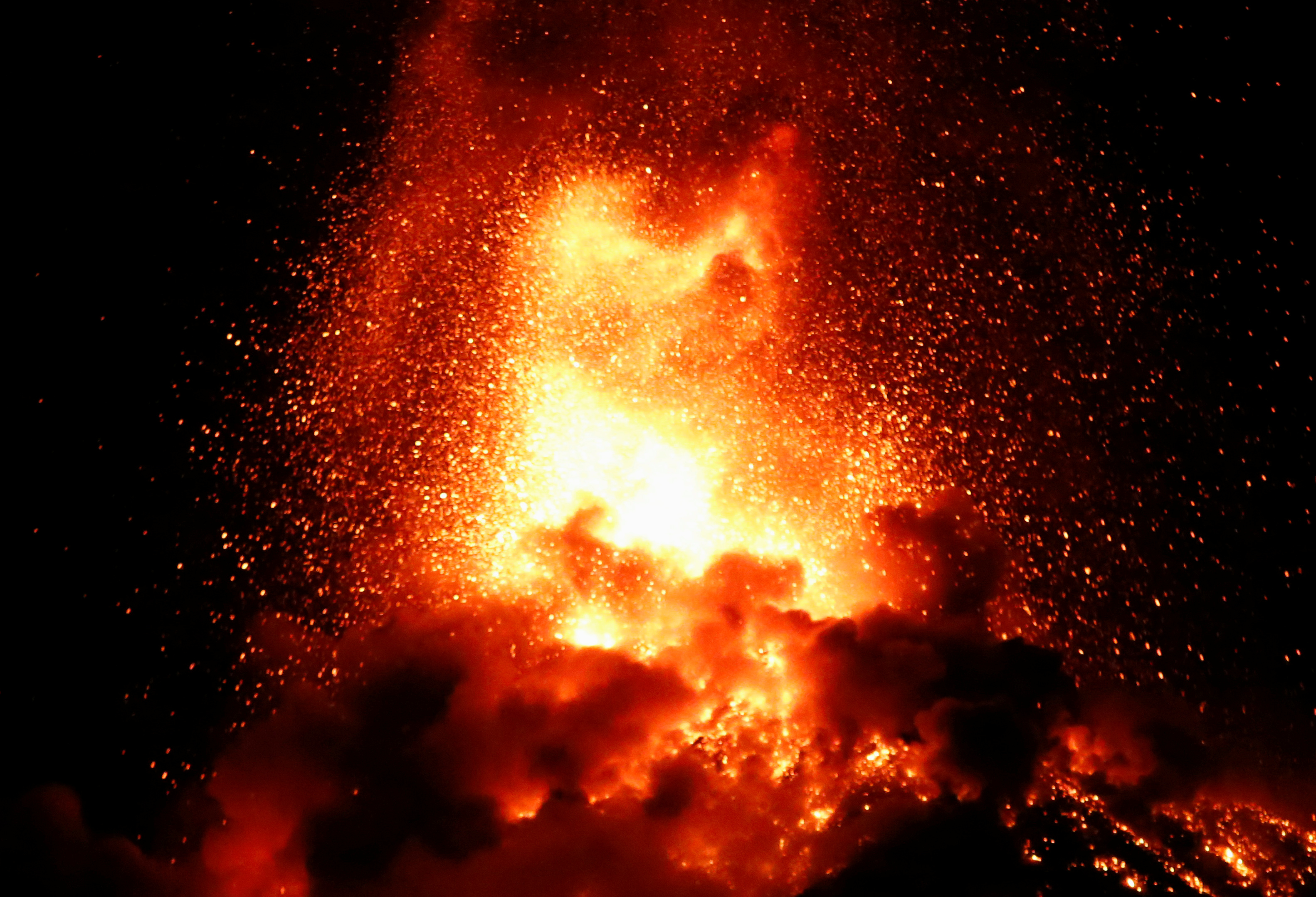
PARADISE, Calif. (Reuters) – Convoys of fire engines rumbled through the smoldering northern California town of Paradise on Tuesday on their way to combat still-active sections of the state’s deadliest and most destructive wildfire in history, which grew by 8,000 acres.

Teams of workers wielding chainsaws cleared downed power lines and other obstacles from the streets, while forensics teams mobilized to resume their search for human remains in the charred wreckage of the Butte County town of 27,000, which was almost completely consumed by fire last Thursday, just hours after the blaze erupted.

FILE PHOTO: Ken's Automotive Service repair shop lies in ruins after wildfires devastated the area in Paradise, California, U.S., November 12, 2018. REUTERS/Sharon Bernstein/File Photo

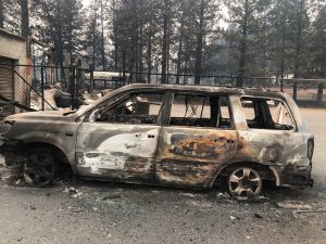
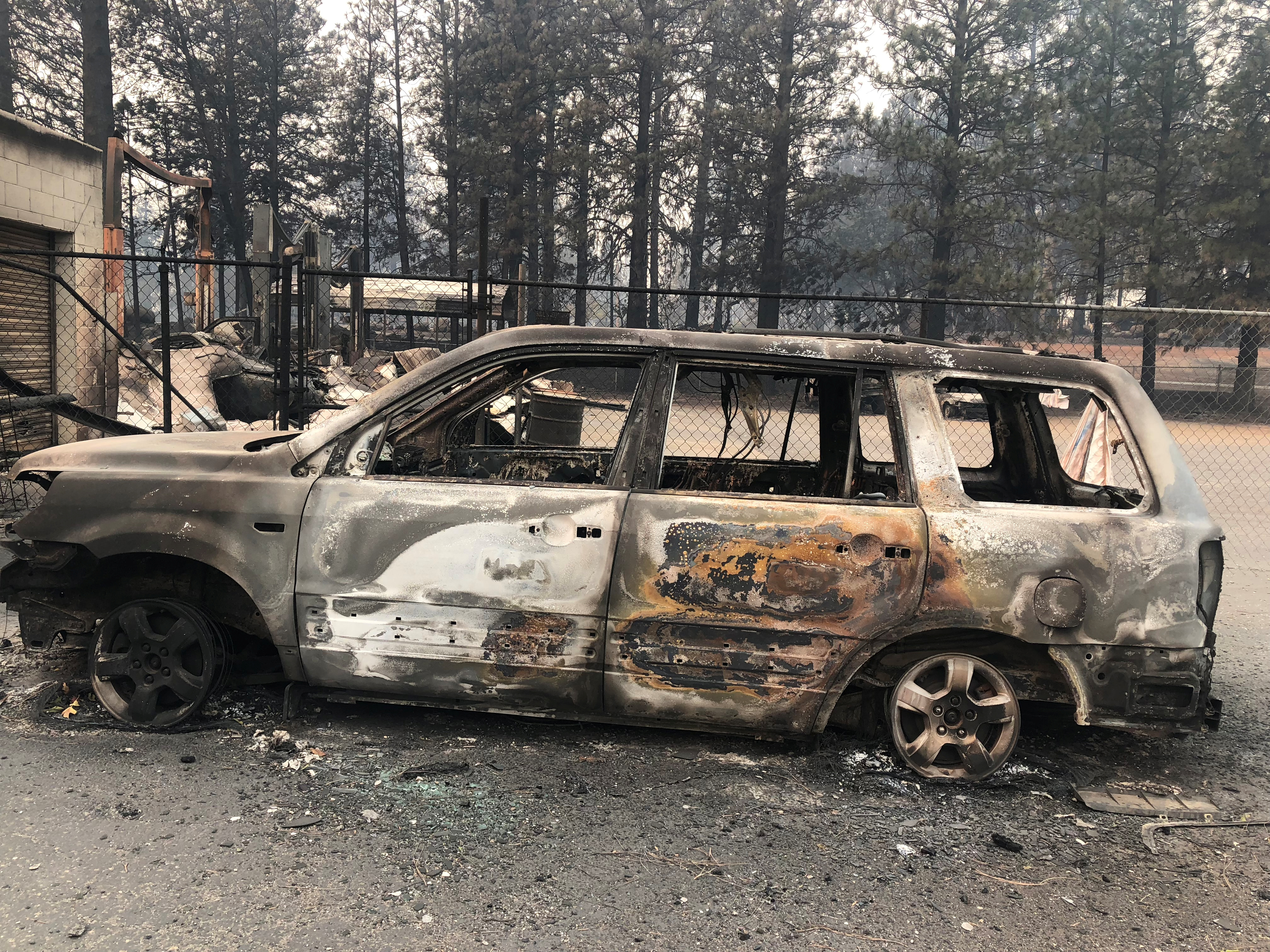
FILE PHOTO: Ken’s Automotive Service repair shop lies in ruins after wildfires devastated the area in Paradise, California, U.S., November 12, 2018. REUTERS/Sharon Bernstein/File Photo

The “Camp Fire” continued to rage in Butte County, about 175 miles (280 km) north of San Francisco, and expanded to 125,000 acres (50,500 hectares), more than four times the area of the city, the California Department of Forestry and Fire Protection (Cal Fire) said. It was 30 percent contained.

The death toll stood at 42 people, the most on record from a California wildfire. More than 7,600 homes and other structures burned down, also an all-time high.

Some 228 people are still unaccounted for and listed as missing. Officials asked relatives and friends to keep checking with evacuation shelters and call centers in the hope many of them could be located.

On a residential street in Paradise lined with burned down houses, a team of 10 rescue and forensic workers wearing white suits and helmets used a dog to search for victims.

“Look for skulls, the big bones,” one forensics worker said to others as they used metal poles and their hands to sift through the remains of a house.

Another found a firearm and marked it for later removal.

Across the street, two rescue workers in red led a dog around a burnt-out car and through the foundation of a house.

One hundred fifty search-and-recovery personnel were due to arrive in the area on Tuesday, bolstering 13 coroner-led recovery teams in the fire zone, said Butte County Sheriff Kory Honea.

The sheriff has requested three portable morgue teams from the U.S. military, a “disaster mortuary” crew, cadaver dog units to locate human remains and three groups of forensic anthropologists.


A firefighter extinguishes a hot spot in a neighbourhood destroyed by the Camp Fire in Paradise, California, U.S., November 13, 2018. REUTERS/Terray Sylvester

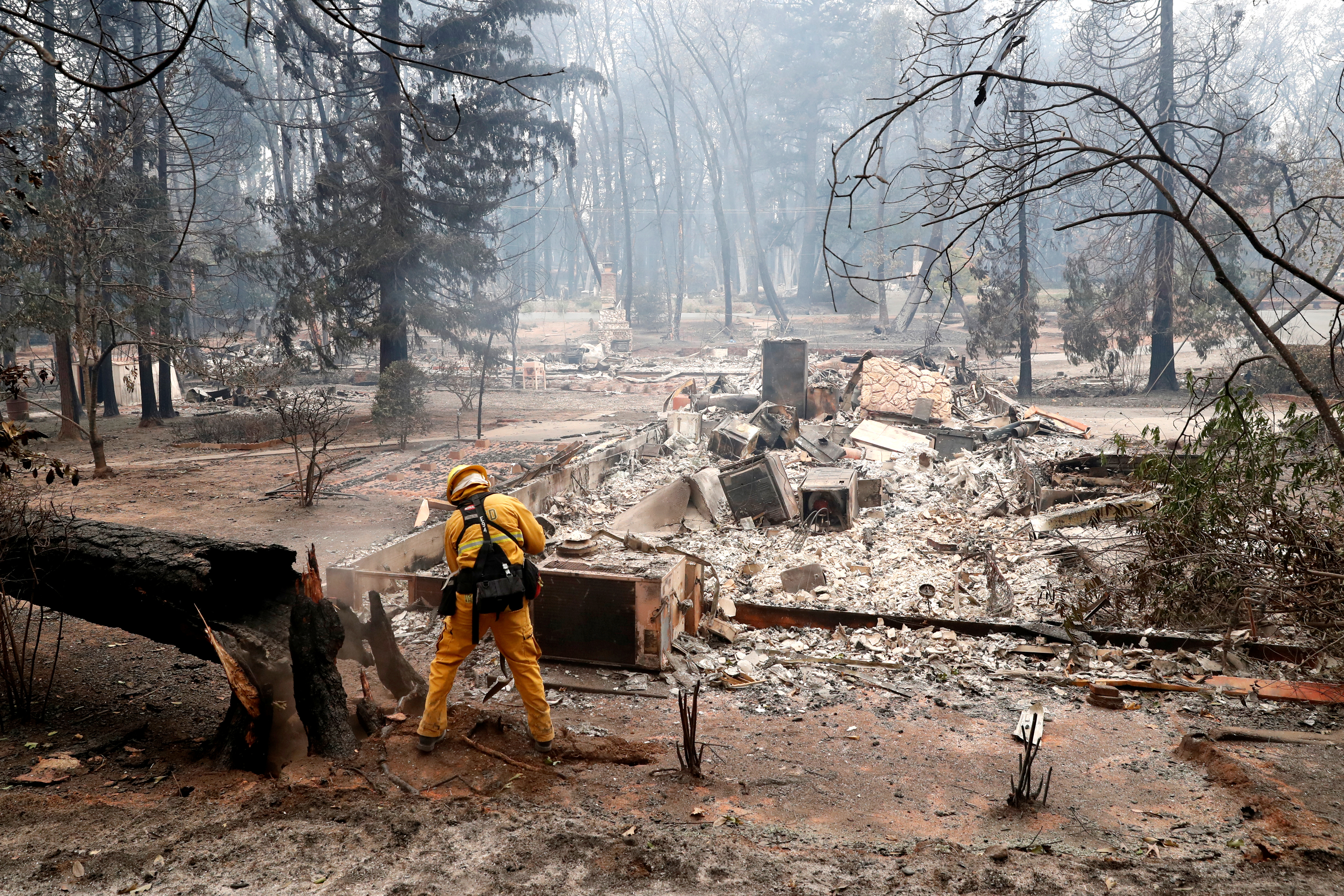
A firefighter extinguishes a hot spot in a neighborhood destroyed by the Camp Fire in Paradise, California, U.S., November 13, 2018. REUTERS/Terray Sylvester

Some 52,000 people remained under evacuation orders and 8,700 firefighters from 17 states have been battling the wildfires.

In Southern California, two people died in the separate “Woolsey Fire,” which has destroyed 435 structures and displaced about 200,000 people in the mountains and foothills near Southern California’s Malibu coast, west of Los Angeles.

The Woolsey Fire was 35 percent contained, up from 30 percent a day earlier, Cal Fire said.

The fires in Los Angeles and Ventura counties burned 96,000 acres (39,000 hectares), roughly the size of Denver and the largest in the area’s 100-year recorded history, officials said, even though air tankers have dropped nearly 1 million gallons (37,000 hectoliters) of fire retardant and 22 helicopters have dropped 1.5 million gallons of water on the fire.

“It is truly heartbreaking,” Los Angeles County Sheriff Jim McDonnell told a news conference. “Hundreds (of homes) still sit in ruins. We fully understand that each house is a home.”

Los Angeles County Fire Chief Daryl Osby said he was hopeful that forecast rainfall next week would help, though it might also provoke landslides.

Four communities were reopened to previously evacuated residents, a sign that firefighters were getting the upper hand, Osby said.

“We’re doing all that we can to allow people to go back home when it’s safe,” Osby said. “I can’t even relate to being evacuated this long. But we will let you go back home when it’s safe.”

President Donald Trump on Monday night declared a major disaster exists from the fires, making federal funds available to people and local government agencies in Butte, Los Angeles, and Ventura counties.

The pledge came two days after Trump blamed the brush fires on forest mismanagement, tweeting “Remedy now, or no more Fed payments!”

He struck a more sympathetic tone while speaking from the White House on Tuesday.

“We mourn the lives of those lost and we pray for the victims,” Trump said while thanking first responders. “We will do everything in our power to support and protect our fellow citizens in harm’s way.”

For a graphic on Deadly California fires, see – https://tmsnrt.rs/2Plpuui

(Reporting by Noel Randewich and Sharon Bernstein; Writing by Daniel Trotta; Editing by Steve Orlofsky and Lisa Shumaker)

Five dead in California wildfire as second blaze forces Malibu evacuation

Firefighters battle flames overnight during a wildfire that burned dozens of homes in Thousand Oaks, California, U.S. November 9, 2018. REUTERS/Eric Thayer

By Stephen Lam

PARADISE, Calif. (Reuters) – A rapidly moving wildfire in Northern California killed five people when flames engulfed their vehicles as they attempted to flee the mountain town of Paradise in one of three infernos raging across the state, authorities said on Friday.

Nearly 500 miles (800 km) to the south, a blaze forced the evacuation of the upscale oceanside city of Malibu, home to many celebrities, and threatened the beleaguered town of Thousand Oaks, where a gunman killed 12 people this week in a shooting rampage in a bar and dance hall.

Since it broke out on Thursday, the so-called Camp Fire has more than tripled in size to 70,000 acres (2,838 hectares) after engulfing Paradise, a town of nearly 30,000 people, and was only 5-percent contained by Friday.

“The town is devastated, everything is destroyed,” said California Department of Forestry and Fire Protection (Cal Fire) spokesman Scott Mclean, referring to Paradise, which has a population of 26,000 including many retirees.

In addition to the five people found dead in their vehicles, many were forced to abandon their cars and run for their lives down the sole road through the mountain town. About 2,000 structures were destroyed in the area, officials said.

The death toll is expected to climb above five, Mclean said, because flames have blocked search and rescue crews from looking for victims in destroyed homes.

“The only reason they found the five is because they were still on the road,” Mclean said.

HOT WINDS

The fires in California have been driven by hot winds from the east reaching speeds of up to 40 miles per hour (64 kph), forcing firefighters to scramble to keep up with the fast-moving flames.

In Southern California, the 14,000-acre (5,666-hectare) Woolsey Fire led authorities on Friday morning to expand mandatory evacuation orders to the entire city of Malibu.

Flames completely engulfed large homes in at least one affluent neighborhood.

“Fire is now burning out of control and heading into populated areas of Malibu,” the city said in a statement online. “All residents must evacuate immediately.”

In all, the Woolsey Fire led authorities to issue evacuation orders for 75,000 homes in Los Angeles and Ventura counties.

It was not immediately clear how many homes had been destroyed.

Video shot from a news helicopter showed cars at a standstill on the Pacific Coast Highway in Malibu, about 30 miles (48 km) west of downtown Los Angeles. An unspecified number of homes were destroyed there, according to local media.

MOVIE SET TOWN ABLAZE

The Woolsey Fire broke out on Thursday and quickly jumped the 101 Freeway. On Friday, it climbed across the Santa Monica Mountains toward Malibu.

It also threatened parts of nearby Thousand Oaks in Ventura County northwest of Los Angeles, the site of the shooting massacre earlier this week, stunning a community with a reputation for safety.

Linda Parks, a Ventura County supervisor, whose district covers Thousand Oaks, lamented the timing of the wildfire. “We are still reeling, but we are also very resilient,” she said.

On its path of destruction, the fire destroyed a Western-themed movie and television set in Agoura, north of Malibu, a unit of the National Park Service said on Twitter.

Western Town was created in the 1950s for television shows such as “The Cisco Kid,” and more recently was used for television shows such as “Westworld” and “Weeds,” and was a draw for visitors.

California Acting Governor Gavin Newsom on Friday declared a state of emergency for areas affected by the Woolsey and Hill fires in Ventura and Los Angeles counties.

In Los Angeles, another fire in Griffith Park forced the Los Angeles Zoo to evacuate a number of show birds and some small primates on Friday as flames came within less than 2 miles (3 km) of the facility, zoo officials said in a statement.

“Animals and employees are safe,” the statement said.

(Writing by Alex Dobuzinskis; Additional reporting by Bernie Woodall and Brendan O’Brien; Editing by Bill Tarrant and Sandra Maler)

Philippines evacuates coastal areas ahead of typhoon Yutu

A general view of the damage after Super Typhoon Yutu hit Saipan, Northern Mariana Islands, U.S., October 25, 2018 in this picture taken through a cracked vehicle window, obtained from social media. Brad Ruszala via REUTERS

MANILA (Reuters) – The Philippines raised storm warning levels on Monday and began evacuating some coastal communities in the path of a typhoon that threatened storm surges, landslides and floods triggered by heavy winds and rain.

Typhoon Yutu, which caused havoc last week with a direct hit on the U.S. Northern Mariana islands, was set to make landfall on Tuesday morning and move across the main island of Luzon before leaving the Philippines 24 hours later, the state weather agency PAGASA said.

By mid-morning on Monday, Yutu was about 400 km (249 miles)east of the mainland and had weakened to sustained wind speeds of 150 km per hour (93 mph), with gusts of 185 kph, from 170 kph recorded a few hours earlier.

That was less intense than four days ago, when as a super typhoon with wind speeds of over 270 kph barreled through the Marianas, a U.S. Western Pacific archipelago of 52,000 people, tearing off roofs, overturning vehicles and cutting off power and water.

Authorities in Isabela and Cagayan provinces started moving residents in coastal towns to evacuation centers while the mountainous Cordillera region was put on red alert for landslides.

Three provinces in north Luzon were elevated to warning signal 3 on the severity scale of 5, and 28 more put on the earliest warnings of 1 and 2, with strong winds and rains expected later on Monday.

Known locally as Rosita, the typhoon will be the 18th to hit the Philippines this year and comes six weeks after super typhoon Mangkhut tore across Luzon, triggering landslides that killed dozens of people and damaged about $180 million of crops.

School classes were suspended in at least five provinces and fishermen in Luzon and the eastern seaboard advised not to go to sea, with warnings of storm surges of up to three metres in six provinces.

All boat services in the port city of Batangas, about 83 km (52 miles) south of Manila, were suspended on Monday.

About half of the Philippines’ 105 million population live in the Luzon region. The country is hit by an average 20 typhoons each year.

(Reporting by Martin Petty and Karen Lema; editing by Darren Schuettler)

Mexicans regroup after Willa’s ‘end of world’ onslaught

Hurricane Willa brings high waves to Puerto Vallarta, Mexico, October 23, 2018, in this still image taken froma video obtained on social media. Edgar Paredes, Irma Paredes via REUTERS

By David Alire Garcia

ESCUINAPA, Mexico (Reuters) – Residents on Mexico’s Pacific Coast on Wednesday began clearing up the wreckage left by Hurricane Willa, which ripped through towns overnight, tearing off rooftops, downing power lines and splitting trees apart.

Willa hit the northwestern state of Sinaloa late Tuesday as one of the strongest storms to lash the coast in recent years, with winds of up to 120 miles per hour (195 km per hour).

“I thought it was the end of the world,” said Alma Rosa Ramirez, a 45-year-old resident of the town of Escuinapa, as she described how her whole house rattled in the blasting winds.

Now with the sun peeking through and wind nearly at a standstill, Ramirez and scores of other residents took to the streets to pick up debris, while emergency crews poured in to work on reestablishing basic services.

Ramirez arrived at her tiny fruit and vegetable stand in the shadow of a large stone church in Escuinapa’s central square, saying she feared the storm had devastated the farming region that supplies her with the carrots, squash and chiles she sells.

Fallen tree is seen at the park in Escuinapa, near the southern tip of Sinaloa state after Hurricane Willa hit the area, Mexico October 24, 2018. REUTERS/Henry Romero

Fallen tree is seen at the park in Escuinapa, near the southern tip of Sinaloa state after Hurricane Willa hit the area, Mexico October 24, 2018. REUTERS/Henry Romero

“There’s going to be a lot of poverty,” she said.

No deaths have been reported as thousands of people were evacuated from coastal towns and resorts before the storm hit.

“The population took cover in time,” said Luis Felipe Puente, head of the country’s Civil Protection agency, confirming that no deaths had been reported as of early on Wednesday.

On the other side of Escuinapa, 74-year-old retiree Virginia Medina sat in a white plastic chair, a 4-week-old kitten winding between her legs, as she took in the damage.

Willa showed her little mercy: a metal corrugated roof collapsed, water pooled in the kitchen and gnarled branches littered Medina’s front patio and backyard.

“I can’t even walk in my backyard … Here in the neighborhood a lot of walls came tumbling down. Now there is no power, no gas, there’s nothing,” Medina said.

Willa struck the coast about 50 miles (80 km) south of Mazatlan, a major city and tourist resort in Sinaloa, as a Category 3 hurricane on the five-step Saffir-Simpson scale.

The storm had reached rare Category 5 status on Monday, with winds nearing 160 miles per hour (260 kph), as it headed toward the coast.

The storm dissipated by mid-morning as it moved quickly inland over northwest-central Mexico on Wednesday. It was still expected to dump heavy rains across the region.

By then, the storm was about 75 miles (120 km) west of the city of Monterrey, blowing maximum sustained winds of 25 mph, the Miami-based U.S. National Hurricane Center said.

Downpours in Mexico prior to Willa’s arrival have heightened the risk of flooding, and the NHC said the storm could drench some areas in as much as 18 inches (45 cm) of rain.

(Additional reporting by Dave Graham and Brendan O’Brien; writing by Anthony Esposito and Daina Beth Solomon; editing by Robert Birsel, Helen Popper, Frances Kerry and G Crosse)

Thousands evacuated as Hurricane Willa descends on Mexico

People board up windows of a store as Hurricane Willa approaches the Pacific beach resort of Mazatlan, Mexico October 22, 2018. REUTERS/Henry Romero

By David Alire Garcia

MAZATLAN, Mexico (Reuters) – Thousands of people were evacuated, buildings boarded up and classes canceled on Mexico’s Pacific coast as Hurricane Willa threatened to batter tourist resorts with high winds and heavy rains on Tuesday.

Residents on Monday night sealed off windows and doors with large wooden planks on hotels facing the historic downtown boardwalk of Mazatlan, a popular coastal city in the state of Sinaloa, as tourists strolled nearby and palm trees swayed in a light breeze.

Forecast to be one of the most powerful hurricanes to enter Mexico from the Pacific in recent years, Willa is expected to strike a few miles south of Mazatlan as soon as Tuesday afternoon.

At a gas station on the city’s outskirts, a steady line of cars queued up to refuel and shop at the neighboring convenience store.

Station attendant Zulema Pardo said residents had been streaming through for hours to stock up on basic items, buying enormous jugs of water and gasoline, and leaving the bread shelf completely empty.

“People are really scared,” she said. “People are crazy and worked up.”

A general view of Mazattlan is seen through a window of a plane as Hurricane Willa approaches the Pacific beach resort of Mazatlan, Mexico October 22, 2018. REUTERS/Henry Romero

A general view of Mazattlan is seen through a window of a plane as Hurricane Willa approaches the Pacific beach resort of Mazatlan, Mexico October 22, 2018. REUTERS/Henry Romero

Late on Monday the storm was advancing about 175 miles (280 km) south-southwest of Mazatlan, Mexico, according to the Miami-based National Hurricane Center (NHC).

Several other tourist getaways in Nayarit, as well as the beach resort of Puerto Vallarta in Jalisco state, also lie near the path of the storm, which is forecast to bring a “life-threatening storm surge, wind and rainfall,” the NHC said.

Willa, which was a Category 4 on the five-step Saffir-Simpson scale, was blowing maximum sustained winds of near 130 miles per hour (215 kph) on Monday night with higher gusts, the NHC said.

Headed northward, Willa is forecast to weaken after hitting the coast, the hurricane center said.

Antonio Echevarria, governor of Nayarit, said more than 10,000 people were being evacuated and schools would be closed. He warned locals not to defy the storm.

“Let’s not play the macho. Let’s not act like superheroes,” he said. “It’s a very strong hurricane, very potent, and we don’t want any tragedies.”

Sinaloa also canceled classes in much of the state.

Up to 18 inches (45 cm) of rainfall could pummel the storm zone, the NHC said. Even buildings up to 500 meters (1,640 feet) from the coastline could lose power and suffer physical damage, Mexico’s National Meteorological Service (SMN) said.

Despite the looming threat, some tourists appeared unfazed.

“It doesn’t ruin the pleasure of being here,” said vacationer Angel Avelar, popping open a beer while dangling his feet off the boardwalk.

“Maybe things will be different tomorrow.”

(Reporting by Dave Graham, David Alire Garcia and Brendan O’Brien; Writing by Daina Beth Solomon; Editing by Andrew Heavens and Raissa Kasolowsky)

‘I should have left’ – Hurricane Michael terrified those who stayed

JW and Helen Neal sit in a hotel one mile from their beachfront house due to Hurricane Michael, in Panama City, Florida, U.S., October 10, 2018. REUTERS/Rod Nickel

By Rod Nickel

PANAMA CITY BEACH, Fla. (Reuters) – Andrew Lamonica, 64, a retired power company worker and lifelong Panama City Beach resident, ignored orders to evacuate ahead of Michael, one of the strongest hurricanes ever to hit the United States and waited out the storm in his rented bungalow.

With a mighty crack, a tall pine crashed onto his house, drenching the interior as rain leaked through the shattered roof. Two other trees on his property came down, but his 2011 Cadillac – “my baby” – survived without a scratch.

“I’ve lived here all my life and the storm brought things I’ve never seen,” Lamonica said. “There were several times I thought maybe I should have left.”

Lamonica was lucky. In the first fatality related to Wednesday’s arrival of Hurricane Michael, local authorities reported a “male subject” was killed by a tree toppling onto his house in the Tallahassee area.

Michael inflicted damage to Panama City unevenly, impaling some businesses with sign poles while leaving others virtually unscathed. By nightfall, the city was under curfew, darkened without power, its streets littered with downed power lines, fallen trees and debris.

Joey Morrison, a 30-year-old glass worker, said Michael beat so hard on his apartment door in Panama City Beach with its 155 mile-per-hour (250 km-per-hour) winds that he had to reinforce it by drilling in screws – and still had to sit against the door to keep it shut.

“I got scared enough that I was thinking, ‘I should have left.’ Because this isn’t like anything that ever happened here,” Morrison recounted.

Some of those who did evacuate from Panama City Beach were no less terrified.

“My God, it’s scary. I didn’t expect all this,” said Bill Manning, 63, a grocery store clerk who left his camper in Panama City to move into a hotel.

He watched through a window as trees and poles swayed.

“Panama City, I don’t know if there will be much left,” Manning said.

Michael crashed ashore at Mexico Beach, about 20 miles (30 km) east of Panama City, as a Category 4 storm before charging inland across the Southeast. Its rapid intensification in the warm waters of the Gulf took many by surprise. As recently as the weekend, Michael was expected to hit the Panhandle as a tropical storm.

Mandatory evacuation orders were largely heeded by the 50,000 residents of Panama City Beach and Panama City, a pair of towns dotted with attractions designed like shipwrecks and volcanoes to amuse the thousands of tourists who flock there during the warm months.

Bill Bryant, a Navy veteran, moved his family into one of the few hotels that remained open.

“The smart thing would have been to evacuate farther inland,” said Bryant, 48.

All but a few businesses had closed and were boarded up by Tuesday evening, leaving streets empty. Even the local Waffle House restaurant was shuttered. The diner chain is famous for its 24-hour service 365 days a year and the “Waffle House Index” – whether it is open or closed – has become an indicator to gauge the severity of a disaster.

(Reporting by Rod Nickel in Panama City Beach, Florida; editing by Bill Tarrant and Lisa Shumaker)