Tropical Depression Cindy still packs a punch after landfall on Thursday

Radar from the continued threat of Tropical Storm Cindy

By Kami Klein

In the wake of the landing of Tropical Depression Cindy, there is extensive flooding in many states, the death of a 10 year old boy from debris in Fort Morgan, Alabama  as well as the damage and injuries from an F2 tornado that plowed through Birmingham, Alabama on Thursday,  From reports by the National Weather Service, this was just the beginning of problems that will be arising from this intense storm system.   

The F2 Tornado that hit a heavily populated area in Birmingham, Alabama Thursday afternoon left extensive structural  damage and injured four people. The Weather Channel also reported that Mayor Tim Kerner of the town of Lafitte, Louisiana (located south of New Orleans) said the rising water may impact homes and vehicles, and he issued a voluntary evacuation for all residents.

The AP has reported that more than a foot of rain has fallen in Ocean Springs, Mississippi. Residents are concerned with the damages and hazards brought by the immense amount of water, including the dangers of alligators that are prevalent in many ponds and will now move into more populated areas.  

Mississippi residents are not the only people concerned about frightening impacts in nature caused by the flooding. The Alabama Cooperative Extension System warned of floating colonies of fire ants in the flood waters.  In a statement, the agency said the fire ants may resemble ribbons, streamers or large balls of ants floating on the water and that residents should be on the lookout when maneuvering in or being near flooded areas.

So far the states of Louisiana, Mississippi, Alabama, Texas, Tennessee and even southern Arkansas have been affected by the torrential rains contained in Tropical Depression Cindy.  Officials in all states have warned that there is a strong possibility for more flash flooding and tornadoes.  

In a report by The Weather Channel, remnants of the storm moved into Tennessee on Friday, knocking down trees and prompting power outages. According to Memphis Light Gas and Water, nearly 10,000 customers were without power Friday morning. Kentucky and West Virginia are bracing themselves for Heavy rainfall and flooding and reports from the weather service show that portions of Michigan and Indiana are also being affected by this storm system as well.  

The National Weather Service says that the path of Tropical Storm Cindy will spread heavy rain into the Tennessee and Ohio Valleys today – and into the Appalachians and Mid-Atlantic tonight. Flash flooding is possible in these areas as well as strong to severe thunderstorms.  


Storm lashes New Zealand quake zone, more buildings evacuated

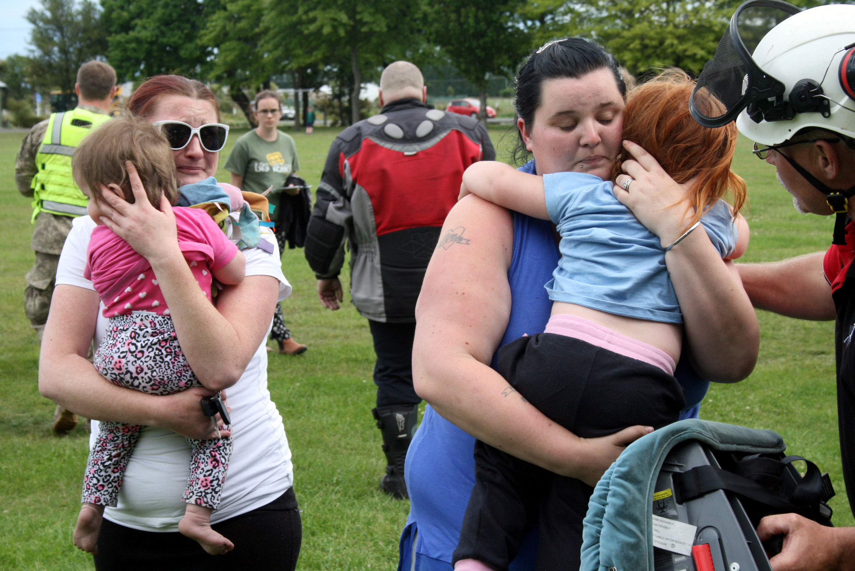
Evacuees formerly stranded in the earthquake-affected town of Kaikoura walk away from the New Zealand Air Force helicopter that brought them to the town of Woodend, near Christchurch, New Zealand,

By Lincoln Feast

CHRISTCHURCH, New Zealand (Reuters) – Rain and strong winds battered central New Zealand on Thursday, threatening further damage just days after a powerful earthquake killed two people and devastated parts of the country’s South Island with huge landslides.

More than 1,000 tourists and residents have been evacuated from the small seaside town of Kaikoura by a fleet of helicopters and a New Zealand naval vessel since the 7.8 magnitude quake struck early on Monday.

Kaikoura, a fishing town and popular whale-watching base ringed by steep mountains, was completely cut off by landslides covering the coastal road and rail corridor.

Further helicopter evacuations from Kaikoura on Thursday had been disrupted due to the bad weather, said Sarah Stuart-Black, director of the Ministry of Civil Defence Emergency Management.

“We are really concerned about the changing weather situation,” she told reporters. “It could mean that there’s an increased risk of further landslides, obviously surface flooding, so we want people to be safe.”

An inland road to Kaikoura, briefly reopened to emergency vehicles, was closed due to more landslides, officials said.

Warships from Australia, Canada and the United States, in the country for the Royal New Zealand Navy’s 75th anniversary, had arrived in Kaikoura to assist with the recovery.

“The ships, crews and maritime helicopters provided by our partner militaries have given us a great deal of flexibility in supporting the national relief effort,” said New Zealand Joint Forces Commander Major General Tim Gall.

Most of the tourists evacuated to Christchurch, the South Island’s largest city about 150 km (90 miles) south of Kaikoura, had continued their journeys but around 130 people were being housed temporarily in Canterbury University’s student halls.

With damage expected to take months to repair, the government announced a NZ$7.5 million ($5.3 million) wage subsidy package to support small businesses in Kaikoura for two months.

“These companies … are going to have a sustained reduction in their turnover to the point of almost nothing for a long period of time and that’s why we think it’s appropriate for the government to step in,” Economic Development Minister Steven Joyce told reporters.

Analysts at ANZ Bank said that, while the local economic hit would be significant, there would only be a “small dent” in New Zealand’s overall activity, far lower than the 2011 quake in Christchurch that killed almost 200 people.

STRUCTURAL DAMAGE

In Wellington, as many as 60 buildings were damaged, including serious structural damage to three relatively recently constructed multi-storey buildings, one of which engineers said would have to be torn down.

The government said it would launch an investigation into why the newer buildings had been unable to withstand the quake.

More buildings were evacuated and roads cordoned off on Thursday as engineers assessed the damage.

Wellington is bisected by several fault lines, and large areas of its business district are built on reclaimed land, raising questions about building practices in the capital despite some of the world’s strictest codes.

“It is a concern, people do want to know the buildings they’re in are going to be safe,” Wellington Mayor Justin Lester told reporters. “Everybody wants a building to perform as is expected, so when it doesn’t … you need to understand how. There’s no simple answer.”

The force of the tremor was most evident in the upper South Island, where parts of the coast moved meters. A team of volunteers rescued thousands of abalone, a large shellfish known locally as paua, that had been thrown up from the sea bed and left high and dry.

Evacuees formerly stranded in the earthquake-affected town of Kaikoura stand alongside the helicopter that brought them to the town of Woodend, near Christchurch, New Zealand

Evacuees formerly stranded in the earthquake-affected town of Kaikoura stand alongside the helicopter that brought them to the town of Woodend, near Christchurch, New Zealand, November 16, 2016. REUTERS/Lincoln Feast

A popular New Zealand fur seal colony near Kaikoura, where pups could often be seeing playing in a waterfall in a nearby stream, was destroyed by a landslide, Department of Conversation officials said.

Civil Defence evacuated some residents near several rivers in the region where landslides from the earthquakes had blocked the rivers and risked dangerous collapses.

Seismologists are still recording hundreds of aftershocks – some 2,000 have rattled the region since the initial tremor.

Government body Geonet Science estimated an almost one-in-three chance of another 7-7.8 magnitude quake hitting the wider region within the next 30 days.

“We stress to Wellington that we need to be prepared,” Lester, the mayor, said.

(This version of the story corrects designation of Lester in final paragraph)

Severe Weather in the Central United States Through Monday Night

By Kami Klein

Severe storms are expected throughout the afternoon and night, Monday into Tuesday, heading through the central states and eastward.  This same storm system produced severe thunderstorms with tornadoes and large hail in Colorado on Saturday and has been steadily advancing eastward according to the National Weather Service.

Accuweather.com and the National Weather Service are both reporting that the storms are expected to begin in the early afternoon along a dryline from eastern Kansas into Oklahoma.  The severe weather will journey eastward into Missouri, Arkansas, Louisiana and eastern Texas Monday afternoon. The National Weather Service warns that the main tornado risk appears to rise considerably once the system tracks into eastern Oklahoma in the late afternoon and into Arkansas during the evening.

Because of the substantial low level vertical shear over this area there is a good potential for strong tornadoes to develop.  Intense supercells will most likely be possible as well.

Accuweather Senior Meteorologist Alex Sosnowski advises, “The storms will bring the potential for frequent lightning strikes, flash flooding and a few isolated tornadoes, along with the ongoing risks of large hail and damaging wind gusts.”

Thunderstorms will continue to push eastward late Monday night into Tuesday morning.  Although there still will be capabilities of gusty winds and flooding downpours, the severe weather systems are expected to lower in intensity.

A few strong storms could redevelop during the day on Tuesday across part of the Ohio Valley as this system slowly drifts eastward.

Please stay tuned to local forecasts and take all precautions for your safety.  Motorists should plan on checking frequently on weather reports to stay clear of active and dangerous weather.  


Weekend Weather Promises Big Mix

This weekend weather promises a big mix of severe storms, snow, flooding and tornadoes. With a storm system moving across the Central and Southern Plains, a cold front on the East Coast and freezing weather setting in across numerous locations, you don’t have to go far for something different in your weather conditions.

According to the National Weather Service, The western U.S. will remain mostly dry through the weekend as high pressure remains in places across the region. Severe thunderstorms in the central and southern plains will produce hail, damaging winds and some tornadoes. This system will also produce flash flooding and snow over portions of the upper great lakes and central rockies.

The Weather Channel reports that multiple rounds of strong to locally severe storms are possible from Delaware and southeastern Virginia to the Carolinas, south/central Georgia, northern Florida, southern Alabama, southern Mississippi, and southeast Louisiana, as a cold front slowly pushes southeast.

A few thunderstorms may also develop farther north into Pennsylvania, New Jersey, New York and New England. The potential impacts of these storms could be damaging wind gusts and large hail, though a few tornadoes are possible.
Flash flooding will remain a threat from the Carolinas and Georgia, southern Alabama, the Florida panhandle, coastal Mississippi and southeast Louisiana.

The National Weather Service also reported that heavy rain and strong storms were expected for the Southeast states and snow with much colder temperatures will be the norm from the upper midwest to the Northeast this weekend.

Several tornadoes were reported in Mississippi and Alabama Thursday evening as a multi-day round of severe weather clobbered the South, and the threat persisted Friday morning into Georgia in reports by The Weather Channel.

One twister touched down in Lowndes County, Mississippi, near New Hope before rising off the ground and touching down again across the state line in Alabama near Ethelsville. Lowndes County Emergency Management Service Director Cindy Lawrence told the Associated Press that at least a dozen homes near New Hope were damaged by the storm, but there were no injuries. Survey crews from the National Weather Service found two EF1 tornadoes hit northern Pickens County in Alabama.

A Mississippi teen was killed earlier in the day Thursday in a wreck on wet roads.

For those of you experiencing any severe weather in your area, please stay tuned to your local weather stations for up to date information.