U.S. Gulf Coast braces for Tropical Storm Cindy

This graphic shows an approximate representation of coastal areas under a hurricane warning (red), hurricane watch (pink), tropical storm warning (blue) and tropical storm watch (yellow). The orange circle indicates the current position of the center of the tropical cyclone. The black line, when selected, and dots show the National Hurricane Center (NHC) forecast track of the center at the times indicated. The dot indicating the forecast center location will be black if the cyclone is forecast to be tropical and will be white with a black outline if the cyclone is forecast to be extratropical. Courtesy of NOAA and the National Weather Service

By Liz Hampton

(Reuters) – Communities and oil refining and production facilities from Texas to Florida braced on Tuesday for potential disruptions as Tropical Storm Cindy strengthened over the U.S. Gulf of Mexico, threatening to bring flash floods across parts of the northern Gulf Coast.

Cindy was located about 230 miles (365 km) south of Morgan City, Louisiana late Tuesday with maximum sustained winds of 60 miles (95 km) per hour, the National Hurricane Center said.

The storm was moving toward the northwest near seven miles (11 km) per hour, and this motion was expected to continue through Wednesday.

On the forecast track, the center of Cindy will approach the coast of southwest Louisiana and southeast Texas late Wednesday, and move inland over southeastern Texas on Thursday, the Miami-based weather forecaster said.

A Tropical Storm Warning is in effect for San Luis Pass, Texas to the Alabama-Florida border, Metropolitan New Orleans and Lake Pontchartrain.

“The winds aren’t looking to get much stronger than they are now,” but some areas east of Houston and toward Florida could see as much as 12 inches of rain, said Stephen Strum, vice president of extended forecast services at Weather Decision Technologies in Tulsa, Oklahoma.

“It’s moving fairly slow, so it’s going to produce rain for a long time,” he added.

Heavy rains and wind could disrupt oil supplies at the massive refining and production centers along the U.S. Gulf Coast, which could drive up prices for consumers. The Louisiana Offshore Oil Port (LOOP), the largest privately owned crude storage terminal in the United States, suspended vessel offloading operations ahead of the storm, but said it expected no interruptions to deliveries from its hub in Clovelly, Louisiana.

Royal Dutch Shell said it suspended some offshore well operations but production was so far unaffected. Anadarko Petroleum said it had evacuated non-essential staff from its Gulf of Mexico facilities.

Exxon Mobil Corp, Phillips 66, and Motiva Enterprises said the storm had not affected their refining operations.

Cindy was expected to produce six to nine inches (15-23 cm) of rain with isolated maximum amounts of 12 inches over southeastern Louisiana, southern Mississippi, southern Alabama, and the Florida Panhandle through Thursday, the NHC said.

Alabama Governor Kay Ivey declared a state of emergency. Officials in Houston, New Orleans and other cities along the Gulf Coast said they were monitoring developments. Florida Governor Rick Scott warned residents in the northwest part of his state to stay alert for flooding and heavy rain.

The storm could cause a surge of one to three feet along the coast and possibly spawn tornados from southern Louisiana to the Florida Panhandle, the NHC said.

The Gulf of Mexico is home to about 17 percent of U.S. crude output and 5 percent of dry natural gas output, according to the U.S. Energy Information Administration. More than 45 percent of the nation’s refining capacity is along the U.S. Gulf Coast, also home to 51 percent of total U.S. natural gas processing capability.

Crude oil prices for physical delivery along the U.S. Gulf Coast were relatively stable, but cash gasoline prices rose as traders expected heavy rains and possible flooding to hit refineries in the region.

Prompt U.S. Gulf Coast conventional gasoline firmed to trade as little as 2 cents per gallon under the RBOB futures contract, its strongest in four months.

WeatherBell Analytics LLC forecast 11 to 13 named tropical storms in the 2017 Atlantic Hurricane Season, according to a May outlook.

The Atlantic hurricane season runs from June 1 through Nov. 30, and has an annual average of 9.6 named storms, 5.9 hurricanes and 2.3 intense hurricanes.

Southeast of the Gulf of Mexico, a second tropical storm, Bret has been downgraded into a tropical wave.

(Reporting by Koustav Samanta, Nallur Sethuraman, Swati Verma, Apeksha Nair and Arpan Varghese in Bengaluru, Catherine Ngai and Devika Krishna Kumar in New York and Liz Hampton in Houston; Editing by Lisa Von Ahn, Chris Reese and David Gregorio)


Portugal’s deadliest fire still rages after 62 people killed

By Axel Bugge

PEDROGAO GRANDE, Portugal (Reuters) – More than 1,000 firefighters were still battling Portugal’s deadliest forest blaze on Monday after it killed at least 62 people over the weekend.

Prime Minister Antonio Costa, who on Sunday visited Pedrogao Grande, a mountainous area about 200 kilometers (125 miles) northeast of Lisbon, called it the biggest human tragedy in Portugal in living memory.

Welcome light rain that started on Monday morning brought only modest relief to the shocked population and exhausted firefighters. Water planes, including French and Spanish ones, resumed their missions after stopping overnight.

“There is still a lot of forest that can burn and the rain does not make much difference,” said Rui Barreto, deputy chief firefighter at the makeshift emergency services headquarters in Pedrogao Grande as thunder rolled through the skies over the ash-covered town.

Firefighters said the weather conditions were still adverse in most areas where the flames were raging. Two army battalions were helping the emergency services.

Dozens of fire engines drove back and forth to fight the raging blaze in areas as far as 20km north of Pedrogao Grande. In a sign of help Portugal is receiving from its European neighbors, four Spanish fire engines were seen driving off from the headquarters.

At least half the victims died in their cars as they tried to flee along a local motorway while many other bodies were found next to the road, suggesting they had probably abandoned their vehicles in panic.

Firefightes work to put out a forest fire near the village of Fato, central Portugal, June 18, 2017. REUTERS/Rafael Marchante

GOVERNMENT ASSURANCES

Despite government assurances that the first response by the emergency services was swift and adequate, many media and residents questioned the efficiency of the operation and the strategic planning in a country which is used to wooded areas burning every year.

“So what failed this Saturday? Everything, as it has failed for decades,” read a headline in the daily Publico, which blamed a lack of coordination between services in charge of fire prevention and firefighting and poor forestry reserve planning.

Police said a lightning strike on a tree probably caused the blaze on Saturday in a region hit by an intense heat wave and dry, gusty winds, which fanned the flames.

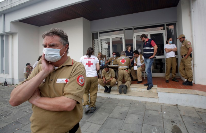
Red Cross and other relief personnel are seen outside a relief centre for people affected by a forest fire in Figueiro dos Vinhos, Portugal, June 19, 2017.

Red Cross and other relief personnel are seen outside a relief centre for people affected by a forest fire in Figueiro dos Vinhos, Portugal, June 19, 2017. REUTERS/Miguel Vidal

The regional prosecutor still ordered a criminal investigation into the causes, which he said would be shelved if the police version of events is confirmed. Many forest fires in Portugal are caused by arson or carelessness.

A public petition circulating on the Internet demanding an investigation into possible failures by the authorities has gathered about 270 signatures.

Local residents said they had been without the support of firefighters for hours as their homes burned. Many blamed depopulation of villages that left wooded areas untended.

(Story repeats fixing typo in second paragraph.)

(Writing by Andrei Khalip, editing by Ed Osmond)

Bangladesh raises highest danger warning as cyclone takes aim

A woman looks on inside her flooded house in Dodangoda village in Kalutara, Sri Lanka May 28, 2017. REUTERS/Dinuka Liyanawatte

By Ruma Paul and Dinuka Liyanawatte

DHAKA/AGALAWATTE, Sri Lanka/ (Reuters) – Bangladesh raised its storm danger signal to the highest level of 10 on Monday as a severe and intensifying cyclone churned toward its low-lying coast and was expected to make landfall in the early hours of Tuesday.

Impoverished Bangladesh, hit by cyclones every year, warned that some coastal areas were “likely to be inundated by a storm surge of four to five feet (1.2 to 1.5 meters)” above normal because of approaching Cyclone Mora.

The Disaster Ministry ordered authorities to evacuate people from the coast, the ministry’s additional secretary, Golam Mostafa, told reporters in Dhaka. About 10 million of Bangladesh’s population of 160 million live in coastal areas.

River ferries had suspended operations and fishing boats called in to safety.

“Maritime ports of Chittagong and Cox’s Bazar have been advised to lower danger signal number seven but instead hoist great danger signal number ten (repeat) ten,” a government weather bulletin said.

“The coastal districts of Chittagong, Cox’s Bazar, Noakhali, Laxmipur, Feni, Chandpur and their offshore islands … will come under danger signal number ten (repeat) ten.”

Bangladesh is hit by storms, many of them devastating, every year. Half a million people had their lives disrupted in coastal areas such as Barisal and Chittagong in May last year.

It is still recovering from flash floods that hit the northeast, affecting millions of people, in April. Rice prices have reached record highs and state reserves are at 10-year lows in the wake of flooding that wiped out around 700,000 tonnes of rice.

The cyclone formed after monsoon rains triggered floods and landslides in neighboring Sri Lanka, off India’s southern tip, which have killed at least 177 people in recent days, authorities said, with 24 killed in storms in the eastern Indian state of Bihar, either by lightning strikes or under collapsed village huts.

India warned of heavy rain in the northeastern states of Tripura, Mizoram, Manipur, Nagaland and Arunachal Pradesh as Mora moved further up the Bay of Bengal.

RUBBER AND TEA PLANTATIONS HIT

Floods reached roof level and cut off access to many rural Sri Lankan villages, disrupting life for 557,500 people, many of them workers on rubber plantations, officials said. Nearly 75,000 people had been forced out of their homes.

Villagers in Agalawatte, in a key rubber-growing area 74 km (46 miles) southeast of the capital, Colombo, said they were losing hope of water levels falling soon after the heaviest rain since 2003. Fifty-three villagers died and 58 were missing.

“All access to our village is cut off. A landslide took place inside the village and several houses are buried,” Mohomed Abdulla, 46, told Reuters.

Some areas in the southern coastal district of Galle, popular with foreign tourists, have not received relief due to lack of access.

“My entire village is cut off and nobody can come to this village,” C.M. Chandrapla, 54, told Reuters by phone from the tourist village of Neluwa.

“There have been no supplies for the past two days. Water has gone above three-storey buildings and people survive by running to higher ground.”

The Sri Lankan military has sent in helicopters and boats in rescue efforts in the most widespread disaster since the 2004 Boxing Day tsunami. About 100 people were missing in total.

The meteorology department forecast torrential rains over the next 36 hours.

Residents in seven densely populated districts in the south and center of Sri Lanka were asked to move away from unstable slopes in case of further landslides.

The wettest time of the year in Sri Lanka’s south is usually during the southern monsoon, from May to September. The island also receives heavy rains in the North West monsoonal season from November to February.

Reuters witnessed some people stranded on the upper floors of their homes. Civilians and relief officials in boats distributed food, water and other relief items.

One of the worst-hit areas was the southern coastal district of Matara which is home to black tea plantations. Rohan Pethiyagod, head of the Tea Board in the world’s largest exporter of top quality teas, said supplies would be disrupted for the next auction due to a lack of transportation.

Sri Lanka has already appealed for international assistance from the United Nations and neighboring countries.

(Additional reporting by Ranga Sirilal in Colombo; Writing by Shihar Aneez and Sanjeev Miglani; Editing by Nick Macfie)

U.S. weather forecasters predict above-normal hurricane season

A hurricane seen from space. Courtesy of Pixabay

By Laila Kearney

(Reuters) – U.S. weather forecasters on Thursday predicted more tropical storms in 2017 than normal for the Atlantic hurricane season, which last year brought one of the deadliest recorded storm systems that killed several hundred people.

Meteorologists with the National Oceanic and Atmospheric Administration’s Climate Prediction Center said there was a 70 percent chance of seeing between 11 and 17 named tropical storms this season, which begins on June 1 and runs for six months.

“There is a potential for a lot of storm activity this year,” Ben Friedman, acting NOAA administrator, said at a press conference in College Park, Maryland.

Five to nine of the storms could become hurricanes, with winds of 74 miles per hour or higher, including two to four major hurricanes, with winds of at least 111 miles per hour, Friedman said.

A normal season consists of an average of 12 tropical storms and six hurricanes, including three considered major.

U.S. residents along the Gulf Coast and Atlantic Coast could be affected by the storms, as well as Mexico and the nations surrounding the Caribbean Sea.

The figures for 2017 are higher than last year’s prediction of 10 to 16 storms, with four to eight likely to become hurricanes.

A weak or non-existent El Nino, which typically suppresses the development of Atlantic hurricanes, and warmer sea surface temperatures factor into the predictions, said Gerry Bell, a NOAA hurricane climate specialist.

Forecasters will deploy more sophisticated tools this season to accurately track, image and predict the intensity of storms. They also will revise their model for communicating with the public, in part by sending alerts about storm surge, which is often the most dangerous element of tropical storms.

Despite forecasting advancements, Friedman warned residents, especially in coastal areas, to get ready ahead of time with evacuation plans and emergency supplies.

“We cannot stop hurricanes, but we can prepare for them,” Friedman said.

Last October, Hurricane Matthew killed hundreds of people when it hit Haiti and 34 more in the United States, and caused $10 billion in damage, making it one of the deadliest and most costly storms on record.

NOAA will update its outlook again in August, just before the peak storm season.

(Reporting by Laila Kearney; Editing by Diane Craft and Grant McCool)

At least one killed as tornado tears though dozens of Oklahoma homes: media

(Reuters) – A tornado tore through western Oklahoma on Tuesday evening, destroying or damaging dozens of homes and killing at least one person, media reported.

As many as 70 homes in Elk City, a town of about 12,000 people around 110 miles (180 km) west of Oklahoma City, were damaged or destroyed by the storm, CBS affiliate KWTV reported, citing officials.

One person in a car was killed, the station reported, citing an emergency response official. It was unclear how many people were injured, KWTV said.

The majority of damage occurred on the south side of the city, the Elk City Police Department said in a statement. The department told residents to stay home because power lines were down across the city. The department’s phone lines were also down, it added.

Elk City Public Schools were canceled for Wednesday, the school system said in a statement.

“My thoughts and prayers are with those affected by the tornado in Elk City tonight,” Oklahoma Governor Mary Fallin said on Twitter.

(Reporting by Timothy Mclaughlin in Chicago; Editing by Nick Macfie)

Heavy rain, wind disrupts travel for New Yorkers

A motorcycle is seen in water on the West Side Highway after heavy rain in the Manhattan borough of New York, U.S., May 5, 2017.REUTERS/Carlo Allegri

By Peter Szekely

NEW YORK (Reuters) – Heavy, wind-driven rain soaked the New York City area on Friday afternoon, causing local flooding and an array of transportation delays across the heavily populated region.

The National Weather Service issued flash flood warnings for much of New York City and several suburban counties as a weather system that stretched across much of the Eastern Seaboard dumped three inches of rain on the metropolitan region in three hours.

The rain forced the closure of Manhattan’s West Side Highway, a major thoroughfare along the Hudson River, for at least 10 blocks, and caused extensive traffic delays citywide, New York City’s Office of Emergency Management said.

While the intensity of rainfall had diminished shortly before the evening rush hour, water in flood-affected areas was expected to take several hours to recede.

The weather service received reports of flooding across all five boroughs of New York City, prompting some vehicle rescues, spokesman Tim Morrin said.

“The problem was the rain came down so heavy and so fast that the drainage couldn’t keep up,” Morrin said. “Roads became quickly impassible.”

Many flights in and out of New York airports experienced long delays and there were many cancellations. Hardest hit was LaGuardia Airport, where more than 34 percent of departing flights were delayed and 14 percent canceled, according to FlightAware, a website that tracks air travel.

The PATH rail service that connects New Jersey to Manhattan suspended service on two lines on Friday, citing a power problem.

Flooding forced the temporary closure of the main entrance to Manhattan’s Pennsylvania Station, according to local media. The reports could not be immediately confirmed by Reuters.

The weather-related disruption was especially aggravating for commuters from New Jersey and Long Island suburbs who have endured hours-long delays in recent weeks after derailments and other incidents at Penn Station.

Claire Jones, 19, who commutes from her home in New Jersey to New York, said her New Jersey Transit line running in and out of Penn Station was delayed at least six times this month.

“It’s difficult,” Jones said. “The main thing about time transit is that it’s convenient so you know if you get on this train at this time, you’ll get where you need to go, and when that doesn’t happen, it’s extremely inconvenient.”

Amtrak, which owns and operates New York’s Penn Station and leases tracks and space to NJ Transit and the Long Island Railroad, is planning to close some tracks for weeks and months at a time as it undertakes repairs

The station, with its decaying, century-old rail tunnels extending underneath the Hudson River, is a chokepoint on Amtrak’s Northeast Corridor, which runs from Washington to Boston.

The storm also caused inconvenience at the New York’s Oculus transportation hub in lower Manhattan, which opened only last August. Its roof began leaking, scattering hundreds of travelers, a Twitter-posted picture showed.

The Port Authority of New York and New Jersey, which operates the Oculus at the World Trade Center complex, could not immediately confirm the leak.

(Reporting by Laila Kearney, Gina Cherelus and Jonathan Allen; Writing by Peter Szekely; Editing by Leslie Adler)

Rain threatens U.S. Midwest as flooding force hundreds from homes

Long Creek Bridge on 86 highway, flooding Photo By Austin Metcalf

(Reuters) – Unrelenting rain will drench the already saturated U.S. Midwest on Thursday and Friday, forecasters said, after floods in the region killed at least five people and forced residents in vulnerable areas to evacuate their flooded communities.

Parts of Missouri, Illinois, Arkansas, Indiana and Oklahoma could see as much as an additional 4 inches (10 cm) of rain as a slow-moving system is expected to hover over the region for at least one more day, the National Weather Service said in flood warnings and watches.

“The flooding in the middle part of the county has been unbelievable over the last couple of days … and we have more rain on the way, if you can believe that,” Weather.com meteorologist Ari Sarsalari said during his forecast on Wednesday night.

The National Weather Service issued flash flood warnings and watches along waterways from eastern Texas north through Indiana and into northwestern Ohio as forecasters expected most of the rivers across the U.S. Midwest to crest over the weekend.

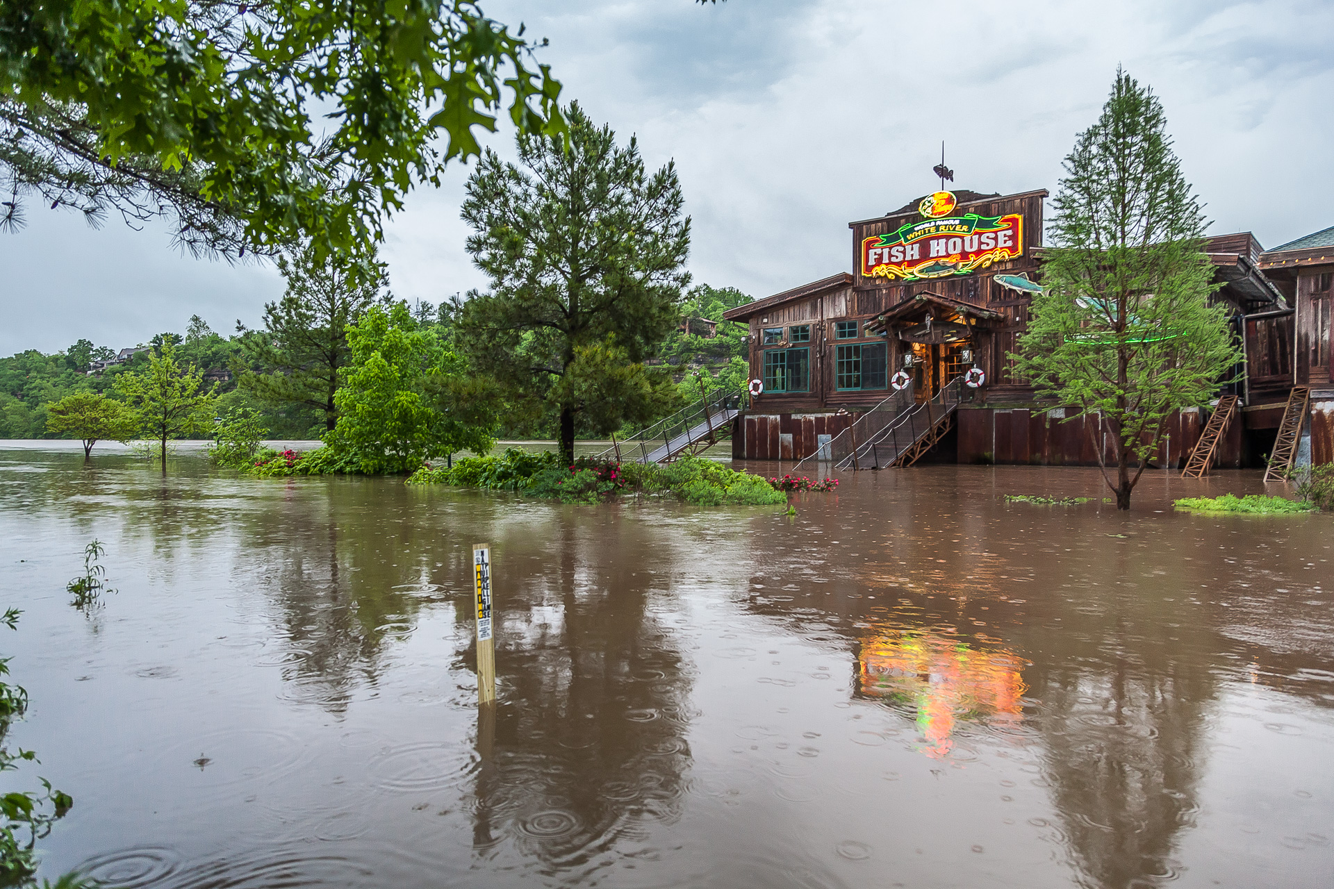
Branson Landing in Branson, Missouri. Photo by Austin Metcalf

Branson Landing in Branson, Missouri.
Photo by Austin Metcalf

The rain comes after five people were killed in flooding in Missouri, the last two of them swept from their cars on Monday and Tuesday, after a storm dumped almost 12 inches (30 cm) of rain in the region over the weekend, the National Weather Service said.

Schools throughout the Midwest canceled classes on Thursday as dozens of roadways and parts of interstate highways remained under water. Amtrak also suspended service in Missouri until at least Saturday, it said in a statement.

The heavy rains have caused levees to fail or to be breached along the Missouri, Mississippi and Ohio rivers and their tributaries over the last few days.

Hundreds of people in places like Eureka, Missouri and Pocahontas, Arkansas have heeded evacuation orders and advisories after building walls of sandbags to protect their homes and businesses from the rising waters.

(Reporting by Brendan O’Brien in Milwaukee; Editing by Toby Chopra)

Torrential rains, damaging winds on tap for U.S. midsection

Stormy weather Courtesy of Pixabay

(Reuters) – A dangerous storm front will thrash the U.S. midsection over the weekend with torrential rainfall, damaging winds and large hail that will leave behind the threat of flooding throughout the region, the National Weather Service warned.

On Friday night, thunderstorms had already clobbered several communities in the southern Midwest with winds that took down trees and power lines while a reported rain-wrapped tornado in Lawrence, Illinois damaged a house, destroyed a structure and caused power outages, the weather service said.

On Saturday, a large swath of the region – from northern Texas up through Michigan – can expect torrential downpours that will produce 7 inches (18 cm) of rain, large hail and damaging wind gusts of 60 miles (95 km) per hour, the weather service predicted.

“The widespread and very heavy rain may produce life threatening flash flooding,” the weather service said in an advisory.

Will Rogers World Airport in Oklahoma City, Oklahoma told travelers on Twitter to “expect delays” and to check their flight with their airline as severe weather moves through the area.

The region has already received about 400 percent or more of normal moisture in the last week and will be highly sensitive to additional rainfall, the service said.

Evacuations could be necessary as areas along swollen waterways could see widespread flooding as the weather service issued flood warnings and watches for the weekend and into next week.

“Be very careful if out in the flooding rain. Many road closures. Never drive through a flooded road,” tweeted Ben Pine, a meteorologist for an ABC affiliate in Louisville, Kentucky.

To the west, a winter storm was expected to dump as much as a foot of wet, heavy snow (30 cm) in parts of Colorado, New Mexico, Kansas and Texas, the National Weather Service said.

(Reporting by Brendan O’Brien in Milwaukee; Editing by Toby Chopra)

Colombia landslide kills at least 17 as rains lash Andes

View of a neighborhood destroyed after mudslides, caused by heavy rains leading several rivers to overflow, pushing sediment and rocks into buildings and roads, in Manizales, Colombia April 19, 2017. REUTERS/Santiago Osorio

BOGOTA (Reuters) – At least 17 people were killed and seven are missing after a landslide sent mud and rocks crashing into several neighborhoods in Manizales, Colombia, the government said on Wednesday, the second deadly landslide in the country this month.

Recent heavy rains have endangered residents in dozens of provincial towns, where makeshift construction on the slopes of the Andes mountains makes neighborhoods particularly susceptible to avalanches and flooding.

The landslide in Manizales, capital of coffee-growing Caldas province west of Bogota, followed a similar disaster in Mocoa, Putumayo earlier this month that killed more than 320 people and displaced thousands from their homes.

“We are helping to find the disappeared … and unfortunately the number will rise,” President Juan Manuel Santos said of the death toll after arriving in Manizales.

At least 57 houses have been affected, the government said. Local media reported that Manizales received a month’s average rainfall just overnight.

Rescuers from the Red Cross, civil defense, firefighters and armed forces are searching for the disappeared in the mud and debris of destroyed buildings.

Running water, electricity and gas services have been suspended in the areas affected by the landslides.

“The situation in Manizales is very worrying. The toll is saddening,” Transport Minister Jorge Eduardo Rojas said after meeting with the province’s governor and the mayor of the city.

The forecast is for at least another two days of rain in the area.

Even in a country where rains, a mountainous landscape and informal construction combine to make landslides a common occurrence, the scale of the Mocoa disaster far surpassed recent tragedies, including a 2015 landslide that killed nearly 100 people.

Colombia’s deadliest landslide, the 1985 Armero disaster, killed more than 20,000.

(Reporting by Julia Symmes Cobb and Helen Murphy; Editing by Phil Berlowitz)

Asylum seekers crossing into Canada increase with warmer weather

A family that says they are from Colombia walks down Roxham Road toward the U.S.-Canada border leading into Hemmingford, Quebec, Canada March 26, 2017. REUTERS/Christinne Muschi

(Reuters) – Canadian authorities caught 887 asylum seekers crossing unlawfully into Canada from the United States in March, nearly triple the number in January, according to numbers released by the government Wednesday.

This brings the total number of asylum seekers caught walking across the border to 1,860 so far this year. The new statistics suggest those numbers could rise further as the weather warms.

Canada is on track to see the highest number of asylum claims in six years, given the pace of claims filed so far, as increasing numbers of people cross into Canada to make refugee claims in the wake of U.S. President Donald Trump’s election and his crackdown on refugees and illegal immigrants.

Under the Canada-U.S. Safe Third Country Agreement, Canada is required to turn asylum seekers away if they try to file refugee claims at land border crossings. But if people cross the border in between formal crossings, they are taken into custody and questioned by both police and border authorities, then allowed to file claims and stay in Canada while they await the outcome.

Refugee advocates have argued that were it not for the Safe Third Country Agreement, people would file claims at border crossings instead.

The people caught crossing unlawfully comprise a fifth of everyone who has filed asylum claims in Canada so far this year but they loom large in Canadian politics, with the federal government taking fire for its wait-and-see approach. Nearly half of the people surveyed in a Reuters/Ipsos opinion poll released in March wanted to deport people illegally crossing into Canada from its southern neighbor.

“The majority of irregular migrants are holders of visas for the United States,” according to a statement released Wednesday from the office of Canada’s Public Safety Minister Ralph Goodale.

“Canadian authorities are managing the increase in asylum seekers in a sound and measured way. … To be clear – trying to slip across the border in an irregular manner is not a ‘free’ ticket to Canada.”

Almost three-quarters of the asylum seekers caught crossing so far this year were taken into custody in Quebec, the government data showed. Roxham Road, which straddles Champlain, New York and Hemmingford, Quebec, has become such a common spot that photographers cluster there and would-be refugees refer to it by name.

Most of the others were taken into custody in Manitoba and British Columbia – 331 and 201, respectively.

Police said Wednesday they have charged 43-year-old Michelle Omoruyi with human smuggling and conspiracy to commit human smuggling. Police allege they found Omoruyi driving nine west African asylum seekers across the U.S. border into the prairie province of Saskatchewan Friday night. The nine asylum seekers have filed refugee claims and are not in custody.

(Reporting by Anna Mehler Paperny; editing by Diane Craft)