Blizzard roars into U.S. Northeast, snarling travel

A lone visitor takes a picture near the brink of the ice covered Horseshoe Falls in Niagara Falls, Canada.

By Gina Cherelus and Scott Malone

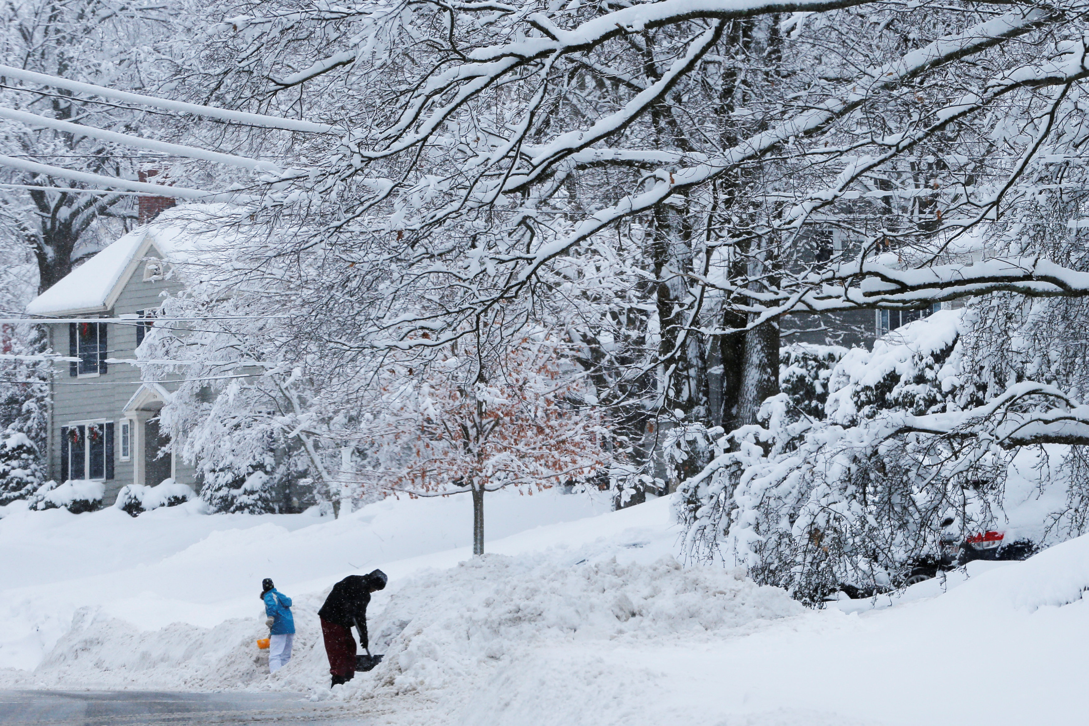
NEW YORK/BOSTON (Reuters) – The first major winter storm of 2018 bore down on the U.S. Northeast on Thursday, closing schools and government offices and disrupting travel as work crews scrambled to clear roads of snow before plummeting temperatures turn it to treacherous ice.

After bringing rare snowfall to the southeast a day earlier, the storm carried rapid accumulation and high winds to New York, where subway systems appeared less crowded than usual as many commuters heeded officials’ warnings to stay home.

Blizzard warnings were in place along the coast from North Carolina to Maine, with the National Weather Service forecasting winds as high as 55 miles per hour (89 kph) that may bring down tree limbs and knock out power.

More than a foot (30 cm) of snow was forecast for Boston and coastal areas in northern New England.

The storm is the product of a rapid and rare plunge in barometric pressure that some weather forecasters are referring to as bombogenesis, or the so-called “bomb cyclone.”

The term comes from the merging of two words: bomb and cyclogenisis, according to private forecaster AccuWeather.

On Wednesday, the storm dumped snow on Florida’s capital Tallahassee for the first time in 30 years, and was expected to last through the day.

About 3,000 airline flights within, into or out of the United States were canceled ahead of the storm’s arrival on Thursday, with New York’s three major airports and Boston’s Logan International seeing as many as three out of four flights called off, according to tracking service FlightAware.com.

Federal government offices planned to delay opening for two hours on Thursday, while state officials in Connecticut and Massachusetts ordered non-essential workers to stay home. In Maine, Governor Paul LePage ordered state offices closed for the day.

“Travel conditions are expected to be treacherous,” LePage said in a statement. “Avoiding unnecessary travel will keep accidents to a minimum and allow state and municipal road crews to safely go about their work.”

The snow storm brought a break in extreme cold temperatures that have gripped much of the region since Christmas, frozen part of the Niagara Falls, played havoc with public works and impeded firefighting in places where temperatures barely broke 20 degrees Fahrenheit (minus 6 centigrade).

But forecasters warned temperatures would drop sharply on Friday and into the weekend. That left work crews scrambling to clear snow off roadways and sidewalks on Thursday before it freezes to ice and makes conditions more treacherous for pedestrians and drivers alike.

“These are tough conditions to move around in, so if you don’t need to be on the road … you shouldn’t,” said New York Mayor Bill de Blasio on Twitter. “Everyone needs to take this weather very seriously.”

Schools were ordered to close in New York, many parts of New Jersey, Boston and other cities through the region.

A woman walks down the street during a blizzard in Long Beach, New York, U.S. January 4, 2018.

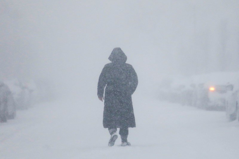
A woman walks down the street during a blizzard in Long Beach, New York, U.S. January 4, 2018. REUTERS/Shannon Stapleton

SOUTHERN SNOW

Private forecaster AccuWeather said snow would fall quickly during the day, at a rate of several inches per hour, with the storm intensified by the bombogenesis effect.

The phenomenon occurs when a storm’s barometric pressure drops by 24 millibars in 24 hours. As a result, the accumulation of snow and winds intensifies, which can cause property damage and power outages.

More than 35,000 customers were without power in Georgia, North Carolina and Virginia early on Thursday, utilities reported online.

A part of US-13 at the Chesapeake Bay Bridge-Tunnel in Virginia was closed due to high winds early on Thursday while state transportation departments throughout the region reported dozens of delays due to deteriorating roads conditions.

Late on Wednesday, a baggage car and two sleeper cars on an Amtrak train traveling from Miami to New York, with 311 passengers aboard, derailed as it was slowly backing into a station in Savannah, Georgia. No one was injured, an Amtrak spokesman said.

The cold has been blamed for at least nine deaths over the past few days, including those of two homeless people in Houston.

(Additional reporting by Brendan O’Brien; Editing by Alison Williams and Bernadette Baum)

Late-season snowstorm weakens in the Northeast

Residents clear their cars and street of snow in Weehawken, New Jersey, as the One World Trade Center and lower Manhattan are seen after a snowstorm in New York, U.S. March 14, 2017. REUTERS/Eduardo Munoz

(Reuters) – A late-season snowstorm that swept the mid-Atlantic and northeastern United States began to weaken on Wednesday after killing six people, grounding thousands of flights and closing schools.

Still, millions of people on the East Coast faced temperatures 10 to 25 degrees below average, wind gusts of 30 mph (50 kph) and slick roads and sidewalks as they returned to work and classes on Wednesday.

“Residual snow and slush will refreeze early this morning, resulting in hazardous conditions,” the National Weather Service said in an advisory, urging those who ventured out early to use extra caution.

The rare mid-March “nor’easter” was tapering off over upstate New York and northern New England after dumping as much as a foot (30 cm) of snow with gale-force winds throughout the region on Tuesday, the weather service said.

As life returns to normal for many, students in Boston Public Schools will have the day off while the city and surrounding area continue to dig out from heavy snowfall.

Amtrak said its trains would operate on a modified schedule between New York City and Boston and between New York City and Albany on Wednesday.

On Tuesday, snow fell from the lower Great Lakes and central Appalachians to the Eastern Seaboard and as far south as North Carolina.

Some cities, such as Washington, D.C., and New York, got just a few inches of snow, far less than the anticipated amounts that forced public officials to close schools, stop commuter trains and warn people to stay indoors on Tuesday.

Governors in New York, New Jersey, Pennsylvania and Virginia declared states of emergency before the storm.

“Mother Nature is an unpredictable lady sometimes,” New York Governor Andrew Cuomo told a news conference on Tuesday. “She was unpredictable today.” More than 6,000 commercial airline flights across the United States were canceled for the day, said tracking service FlightAware.com. Utility companies said more than 220,000 homes and businesses were without power at the storm’s peak.

Six weather-related fatalities included the death of a 16-year-old girl in a single-car crash in Gilford, New Hampshire, according to the city police department.

A snowplow driver was killed in Longmeadow, Massachusetts, local police said, and four older people died clearing snow in Milwaukee County, Wisconsin, the local medical examiner said.

The storm capped an unusually mild winter, with otherwise below-normal snowfall on much of the Atlantic coast.

(Reporting by Brendan O’Brien in Milwaukee and Barbara Goldberg in New York; Editing by Lisa Von Ahn)

Flights canceled, roads hazardous as winter storm pummels New England

A man clears snow off his vehicle following a winter snow storm in Somerville,

BOSTON (Reuters) – Hundreds of flights were canceled, scores of vehicle crashes reported and schools and government offices shuttered as the third winter storm in five days slammed New England on Monday.

Government offices were closed throughout Maine, with much of the state’s coast expecting to see 18 inches to 24 inches (46-61 cm) of snow by the day’s end, according to the National Weather Service.

“Travel conditions are expected to remain treacherous throughout Monday,” said Maine Governor Paul LePage. “Stay off the roads and avoid traveling unless it is an absolute emergency.”

Substantially less snow fell further south, though wind gusts of up to 55 miles per hour (89 kph) threatened to down tree limbs and power lines, forecasters warned.

Courts were closed throughout New Hampshire and Massachusetts, prompting a one-day delay in the start of jury selection for the double murder trial of former New England Patriots star Aaron Hernandez.

Some 675 U.S. flights were canceled on Monday, with Boston’s Logan International Airport the hardest hit with more than one of every five flights called off, according to tracking service FlightAware.com.

Residents dig out following a winter snow storm in the Boston suburb of Wakefield, Massachusetts, U.S.

Residents dig out following a winter snow storm in the Boston suburb of Wakefield, Massachusetts, U.S. February 13, 2017. REUTERS/Brian Snyder

At least one storm-related death was reported in Bedford, Massachusetts, about 15 miles (24 km) northwest of Boston, where a 60-year-old man died after he was struck and killed by a snowplow in the parking lot of the Veterans Administration hospital where he lived, police said.

The recent flurry of snowstorms follows a winter that has been mild throughout New England.

National Weather Service data on Monday showed that even with the most recent snowfall, Boston had recorded just 32.4 inches (82 cm) of snow so far this year.

That’s less than half the amount the city had experienced by this time of year in the record-setting winter of 2014-2015, when more than 9 feet (2.74 m) of snow fell and some snowbanks lingered on until the summer.

(Reporting by Scott Malone; Editing by Bernadette Baum)

Two die as winter storm wallops northeastern United States

Pedestrians walk in Times Square as heavy snow falls

By Scott Malone and Jonathan Allen

BOSTON/NEW YORK (Reuters) – The fiercest snowstorm of the winter slammed the northeastern United States on Thursday, leaving a foot (30 cm) of snow in places, canceling thousands of flights and shutting down schools. At least two deaths were blamed on the storm.

The storm, which came a day after temperatures had been a spring-like 50 to 60 degrees (10 to 16C), had wind gusts up to 50 miles per hour (80 kph) and left roads and sidewalks dangerously slick in densely populated cities such as New York, Boston and Hartford, Connecticut.

The storm’s winds reached as far south as Virginia, where a truck driver died after his tractor-trailer was blown off the Chesapeake Bay Bridge-Tunnel, Tom Anderson, the facility’s deputy director, said in a phone interview.

A New York City doorman died while shoveling snow as he slipped and fell down a flight of stairs, crashing into a window that cut his neck, police reported.

Some areas experienced “thunder snow,” violent bursts of weather featuring both snow and lightning.

Nearly two-thirds of the flights into or out of the three major New York-area airports were canceled, as were 69 percent of those at Boston Logan International Airport, according to Flightaware.com.

Nationwide, about 4,000 flights were canceled and 5,700 delayed.

“The roads are dangerous,” New York Governor Andrew Cuomo told reporters. “I don’t care if you have a four-wheel-drive car and you think you’re a super hero … if you don’t have to be out, don’t be out.”

David Hassan, 50, attested to the ugliness of the weather as he packed up his mobile coffee cart in New York’s Times Square.

“I don’t like coming out in this weather but I have three kids going to school and I have to work,” Hassan said as he prepared for the two-hour trip back to his home in Parsippany, New Jersey.

New York received about a foot of snow, while Boston was braced for up to 20 inches.

Many schools systems were closed in the area, and Boston schools would remain closed on Friday, Mayor Marty Walsh said.

Many government offices also were shuttered with Massachusetts and Connecticut ordering non-emergency workers to stay home.

Blizzard warnings were in effect for the New York’s eastern Long Island suburbs, southern Connecticut and Rhode Island, as well as the Massachusetts coast.

Temperatures were expected to fall to single-digit Fahrenheit levels overnight in the Boston area.

(Additional reporting by Gina Cherelus and Daniel Trotta in New York, Ian Simpson in Washington and Svea Herbst-Bayliss in Providence, Rhode Island; Editing by Larry King and Bill Trott)

A foot of snow, icy cold forecast for northeastern U.S.

woman walks through snow in New York City

By Scott Malone and Joseph Ax

BOSTON/NEW YORK (Reuters) – The heaviest storm the northeastern United States has seen this year was bearing down on the region on Thursday, forcing schools in major cities to cancel classes and airlines to ground thousands of flights.

Forecasters predicted the storm could bring more than a foot (30 cm) of snow and wind gusts up to 50 miles per hour (80 kph) from Pennsylvania through Maine.

New York City schools, the largest public school system in the United States, with more than 1 million students, canceled classes on Thursday. So did districts in Boston and Philadelphia.

More than 2,700 flights in and out of the region were also canceled, according to Flightaware.com, as airlines told passengers to check the status of their flights before heading to the airport.

Blizzard warnings were in effect for the eastern end of New York’s Long Island, Cape Cod, Massachusetts and the island of Nantucket.

“Early start. Getting Ready to go out and battle the snow storm so that I can do what I need to do,” tweeted IT professional Andy Quayle in New York City.

With the storm expected to dump as much as to three inches (8 cm) per hour and start before the morning rush hour and last into the evening, mayors of major cities, including New York and Boston, warned residents to stay off the roads.

“Visibilities will become poor with whiteout conditions at times. Those venturing outdoors may become lost or disoriented. So persons in the warning area are strongly advised to stay indoors,” the National Weather Service said in an advisory.

Temperatures were expected to fall to single-digit Fahrenheit levels (below -12.8°C) overnight in the Boston area.

The forecast comes a day after much of the northeast saw spring-like weather, with temperatures of 50 to 60 degrees Fahrenheit (10 to 16°C).

“I’ve never seen anything like this in my life, you know, what feels like a summer day, almost, now, and then tomorrow a blizzard,” New York Mayor Bill de Blasio told WCBS-AM radio. “But it’s going to be a blizzard and New Yorkers should get ready.”

While temperatures had been mild for much of the region on Wednesday, New England highways were clogged with scores of car crashes that morning after an early rain storm coated roads in ice. At least one person was killed in Massachusetts when he was struck by a car as he tried to help another motorist..

“We want people to stay indoors as much as possible,” Boston Mayor Marty Walsh told reporters on Wednesday.

(Reporting by Scott Malone, editing by Larry King)

Preparation and driving tips for incoming Midwest ice storm

By Shirette Stockdall

Multiple weather services (including The Weather Channel, AccuWeather, and the National Weather Service) are reporting a widespread ice storm to hit the U.S. Midwest this weekend. Winter storm watches have been placed in several counties ranging from Texas to Ohio. This storm is expected to bring freezing rain/sleet starting Friday, January 13th and continue throughout the region until Tuesday, January 17th.

The Weather Channel reports that the storm will slowly move north throughout the weekend. Radar shows that the storm will hit Oklahoma, Kansas, Missouri, Illinois, and Indiana with the most ice. By Monday, the freezing rain/sleet will move north, hitting Iowa, Wisconsin, and Michigan until Tuesday.

Despite the storm moving across the Midwest, meteorologists warn that ice accumulation could get up to half an inch. This is more than enough to weigh down trees and damage power lines, meaning that hundreds of thousands could be without power during the weekend, according to The Weather Channel. Ice will also accumulate on the roads, leading to dangerous driving conditions.

The National Weather Service is warning drivers to stay off the roads, but also provided driver safety tips on Twitter for those who do have to brave the storms.

Additionally, multiple weather services are advising residents in these regions to stock up on preparation items for the storm. These items include:

Flashlights, candles
Batteries
Battery powered radio
Extra Prescriptions/medications
First Aid Kit
Bottled Water
Nonperishable Food
Extra fuel for your generator
A cooler with ice to store cold foods
Extra blankets/warm clothes
Extra toiletries
Cash

Other actions can be taken to prepare for the storm. Make sure to charge all electronics before the power could possibly go out. If you have a generator, run it before the storm hits, make sure it has plenty of fuel or is full charged, and train all family members to be able to operate it. Teach family members basic first aid. Unplug sensitive appliances before the storm hits. If your house will be without heat for a couple days, make sure to drain all of your water pipes to avoid bursts. And if you do lose power, keep your refrigerator closed. Frozen food will keep for approximately 48 hours in the fridge, even without power.

Stay safe and stay warm!

Blizzard baring down on North, South Dakota

December 26th Weather map

(Reuters) – North and South Dakota entered a second day of blizzard conditions on Monday as a strong winter storm closed roads across the region.

The National Weather Service forecast as many as 15 inches of snow to fall in some areas before the storm leaves the area. Authorities in both states told drivers to stay off the roads due to low visibility, snow, wind and ice accumulations.

“Nearly every highway has been shut down (or no travel is advised) during the overnight hours across North Dakota and the western half of South Dakota,” the weather service said.

The weather service also issued blizzard and winter storm warnings for parts of Montana, Wyoming, Nebraska and Minnesota.

The Rapid City, South Dakota office of the weather service reported early on Monday morning that 5.7 inches of snow had fallen already, with more on the way. Power was out on Monday morning for more than 12,000 customers in the states as well, according to area utilities.

The storm had limited impact on people ending their Christmas holiday with plane travel. Flight tracking website flightaware.com reported fewer than 200 cancellations and delays across the country.

The storm is set to continue its northeastern track, which will take it to Quebec, Canada by Tuesday, the weather service said.

(Reporting by Curtis Skinner in San Francisco; Editing by Robin Pomeroy)

Cold persists in U.S. Midwest as Pacific Northwest braces for snow

People walk by snow-covered statue

(Reuters) – Arctic air blowing through Chicago and other parts of the U.S. Midwest was expected to keep the region under a deep freeze on Wednesday, as residents of Oregon were blanketed with snow from a separate weather system, forecasters said.

Temperatures in Chicago, the nation’s third largest city, were expected to plunge to between 13 and 22 degrees Fahrenheit (minus 11 to minus 5 degrees Celsius) with a wind chill factor as low as minus 15 degrees Fahrenheit, the National Weather Service said in an advisory.

Arctic air spreading from Canada across much of the northern United States this week has led authorities to warn people against frostbite.

The Midwest was expected to experience colder weather than on Tuesday, at the outset of the arctic air blast, National Weather Service meteorologist Andrew Orrison of the agency’s Weather Prediction Center said by telephone.

“People certainly, if they’re going to be out and about, need to dress warmly and wear multiple layers of clothes,” Orrison said.

A few inches of snow could fall on areas around the Great Lakes in Michigan and New York state, he said.

But snowfall from another storm coming to the Pacific Northwest and Northern California was likely to cause greater havoc for people’s travel plans than the snow around the Great Lakes, Orrison said.

The snowfall is due to a Pacific low pressure system and expanding moisture, National Weather Service officials said in a national advisory.

Between 4 and 8 inches (10 and 20 cm) of snow could fall in central and eastern Oregon, with the Cascade mountain range in the Pacific Northwest receiving up to 1 foot of snow, Orrison said.

The weather system that will cover parts of the Pacific Northwest with snow was expected to spread eastward later in the week.

Meanwhile, the blast of arctic air that has placed the Midwest under a deep chill will also blow eastward, bringing potentially record low temperatures to parts of the mid-Atlantic region on Thursday, Orrison said.

Cities from Boston to Washington will feel the chill beginning on Thursday and lasting at least until Friday, he said.

“For these areas it will be the coldest air of the season so far,” Orrison said.

(Reporting by Alex Dobuzinskis in Los Angeles; Editing by Alison Williams)

Colorado blizzard closes Denver airport, more than 100,000 without power

(Reuters) – A blizzard shut down Denver International Airport on Wednesday, canceling more than 1,000 flights after it temporarily knocked out power and made takeoffs and landings unsafe, airport officials said.

The storm, which hit the Denver area early on Wednesday, caused ripple effects in other parts of the country, as planes were forced to sit on tarmacs while awaiting clearance to depart for Denver.

“Denver International Airport has made the decision to close the airport until further notice,” the airport said on Twitter. “Passengers should not plan on coming to the airport until further notice.”

The closure came one day after a suspicious package was found at the airport’s main terminal, prompting a brief evacuation amid heightened security in response to deadly suicide bombings in Brussels.

Power was knocked out at the airport for more than an hour on Wednesday, briefly preventing crews from fueling and de-icing aircraft, airport spokesman Heath Montgomery said.

A total of 573 departing and 549 arriving flights had been canceled at the airport by about 1 p.m. MDT, according to flight tracking website FlightAware.com.

Other flights destined for Denver were delayed by more than five hours, the Federal Aviation Administration said.

Blowing and drifting snow prompted the closure of Interstate 70 just east of Denver to the Kansas state line, the Colorado Department of Transportation said on it website.

Stretches of Interstate 25, the main north-south highway through the state’s urban corridor, were also shut down from Colorado Springs to the Wyoming border due to the adverse weather conditions and multiple accidents, the department added.

Authorities discouraged driving throughout eastern Colorado.

“When tow trucks and fire trucks are getting stuck it’s bad,” the Colorado State Patrol said on its Twitter feed.

Separately, 118,000 customers in the Denver metropolitan area were without electricity due to damaged power lines from ice buildup, fallen trees and high winds, said Xcel Energy spokesman Mark Stutz.

The Denver metropolitan area was expected to see between 6 inches and 12 inches of snow on Wednesday, with the fierce storm moving across northern and northeastern Colorado, the National Weather Service said.

The weather system is expected to move on from the central Rocky Mountains to the upper Midwest as it heads toward New England, the weather service added.

(Reporting by Keith Coffman in Colorado Springs and Alex Dobuzinskis and Dan Whitcomb in Los Angeles; Editing by Peter Cooney and Sandra Maler)

New England shivers under blanket of snow at onset of spring

BOSTON (Reuters) – Residents of much of coastal New England woke up on the second day of spring to discover lawns and roads blanketed with snow and schools closed in Boston, Providence and several other cities.

But the last gasp of winter, forecast to drop as much as 6 inches of snow on Boston, was expected to be brief, with temperatures expected to rise to about 40 degrees Fahrenheit by the afternoon.

The snowfall, which followed several days of seasonable warmth, left some Bostonians puzzled about clothing choices, with pedestrians taking to the streets in shorts and sneakers despite the short lived storm.

“It’s going to compact quickly and also melt. We are expecting temperatures this afternoon to rise into the upper 30s to mid 40s across southern New England, so that’ll promote melting,” said Kim Buttrick, a meteorologist with the National Weather Service in Taunton, Massachusetts. “This is all going to pass.”

The forecast for the storm had been erratic over the weekend, swinging from predicting as much as 10 inches of snow in Boston to the possibility of the storm tracking east over the ocean and missing the city entirely.

“I was expecting more snow. If I didn’t have to work I’d be at home. Definitely,” said Rico Ricard, 36, who was walking from the subway to his job at a city facility in Cambridge, Massachusetts, just outside Boston.

Winter storm warnings were in effect for parts of Massachusetts, Rhode Island, New Hampshire and coastal Maine, with as much as a foot of snow forecast for northern parts of the northeasternmost U.S. state.

The storm slowed travel in the region, with Boston Logan International Airport reporting 13 percent of departing flights canceled, as well as 9 percent of arrivals.

It proved a bit of a damper for businesses that depend on balmier weather, though it didn’t stop 45-year-old Jason Sanford from setting up a line of bicycles outside of the Broadway Bicycle School shop, a move intended to signal that the store was open despite the weather.

“Luckily, we’ve had nice weather, so we have a basement full of tune-ups,” Sanford said. “Hopefully we’ll get ahead of it today.”

(Reporting by Scott Malone Editing by W Simon)