Philippines raises volcano alert level after lava flow

Mount Mayon erupts in Legazpi City, Philippines, January 13, 2018 in this still obtained from social media. Picture taken January 13, 2018.

By Enrico Dela Cruz

MANILA (Reuters) – The Philippines raised the alert level at its rumbling Mayon volcano to “level 3” on Sunday after detecting lava flow and indications of activity that could lead to eruptions of magma.

More than 900 families have been evacuated from villages near Mayon, a tourist attraction because of its near-perfect cone shape, following a “steam-driven eruption” on Saturday.

Authorities advised people to cover their noses and mouths with a damp, clean cloth or dust mask if they were exposed to ash from the eruptions, and said aircraft must avoid flying close to the volcano’s summit.[nL4N1P807T]

Two similar “phreatic” eruptions occurred at the volcano in central Albay province on Sunday, unleashing more ash.

“Mayon’s summit crater is now exhibiting bright crater glow that signifies the growth of a new lava dome and beginnings of lava flow towards the southern slopes,” the Philippine Institute of Volcanology and Seismology (Phivolcs) said.
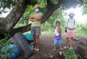
Residents wait for a military truck as they flee home for safety after Mayon volcano erupted in Camalig town, Albay province, south of Manila, Philippines January 14, 2018.

Residents wait for a military truck as they flee home for safety after Mayon volcano erupted in Camalig town, Albay province, south of Manila, Philippines January 14, 2018. REUTERS/Rhadyz Barcia

Phivolcs chief Renato Solidum said the volcano appeared due for another major eruption as it has been displaying abnormal behaviour since late last year.

“Alert level 3 is what we considered critical, 4 is when eruption is imminent, and 5 is eruption in progress,” Cedric Daep, head of the Albay Provincial Disaster Risk Reduction and Management Office, said in a radio interview.

Mayon’s most destructive eruption was in February 1841, when lava buried a town and killed 1,200 people. It last erupted in 2014, spewing lava and forcing thousands of people to evacuate.

The latest eruptions began on Saturday, unleashing ash, rocks and sulphur fumes and accompanied by rumbling sounds.

Phivolcs had earlier raised the alert to “level 2”, saying the activity was “probably of magmatic origin, which could lead to more phreatic eruptions or eventually to hazardous magmatic eruptions.”

Since Saturday’s first eruption, Phivolcs said it had recorded 158 rockfall events and urged people to stay away from a 6-kilometre (3.7 mile) radius Permanent Danger Zone and a 7-km Expanded Danger Zone on the volcano’s southern flank.

Landslides and sudden explosions or a dome collapse that may generate hazardous volcanic flows are also possible, it said.

People within the slope of the volcano, but outside the danger zones, were told to take precautionary measures against possible roof collapses due to accumulated ash and rainwater, and “lahar”, an Indonesian term for a volcanic mudflow.

And the provincial government suspended Monday’s classes from kindergarten to senior high school in some areas.

(Reporting by Enrico dela Cruz; Additional reporting by Manuel Mogato; Editing by Simon Cameron-Moore and Alexander Smith)

Indonesia shrinks danger zone around grumbling Bali volcano

Mount Agung volcano erupts as seen from Kubu, Karangasem Regency, Bali, Indonesia, December 1, 2017.

JAKARTA (Reuters) – Indonesia shrank the exclusion zone around a grumbling volcano on the resort island of Bali on Thursday after fears of an imminent eruption, allowing farmers to return to their homes.

The 3,000-meter Mount Agung remains on alert for a major eruption, but officials said the danger zone around the crater would be reduced to a six-km (four-mile) radius from 10 km.

“Mount Agung remains in an eruption phase and could affect settlements. All parties are urged to remain cautious,” Agung Pribadi, press relations officer at the natural resources ministry, said in a statement.

The volcano has been spewing lava and ash since late November, when authorities raised the alert status to the highest.

Bali airport was closed for three days, leaving thousands of tourists stranded and prompting others to cancel their year-end holiday plans.

(Reporting by Wilda Asmarini; Writing by Kanupriya Kapoor; Editing by Nick Macfie)

Tourists fly out of Bali at last as wind blows volcanic ash away

Tourists fly out of Bali at last as wind blows volcanic ash away

By Sultan Anshori

DENPASAR, Indonesia (Reuters) – Airlines laid on extra flights to the Indonesian holiday island of Bali on Thursday to allow thousands of passengers stranded for days by an erupting volcano to fly home as a switch in wind direction blew the ash away.

But a plume of smoke and ash still rose above Mount Agung on Thursday and the volcano, whose crater glows red, continued to rumble.

Bali airport reopened on Wednesday after being closed on Monday.

“We are happy we can leave now,” American tourist David Strand said at the airport. “It’s been interesting to have the volcano active, but we certainly hope that it doesn’t cause any more damage to the people of Bali.”

The airport on neighbouring Lombok island was closed.

China Southern Airlines and China Eastern Airlines sent planes to fetch more than 2,700 Chinese tourists from Bali, Xinhua news agency said.

Korean Air said it had sent a charter flight. Jetstar said it would fly 3,800 passengers on 10 scheduled flights and six relief flights back to Australia on Thursday. It also encouraged customers booked to fly to Bali up to Dec. 7 to look at alternative destinations.

From January to September, Bali received 4.5 million foreign tourists, nearly half of the 10.5 million arrivals in Indonesia.

Chinese have overtaken Australians to become the top visitors to Bali, representing around a quarter of arrivals on the island.

Losses in revenue could be more than $650 million since the volcano warning level was first raised in September, Indonesian Tourism Minister Arif Yahya estimated.

Agung looms over eastern Bali to a height of just over 3,000 meters (9,800 feet). Its last major eruption in 1963 killed more than 1,000 people and razed several villages.

Authorities are urging people living up to 10 km (6 miles) from the summit to move to emergency centres, but tens of thousands don’t want to leave their homes and livestock unattended.

The disaster mitigation agency said on Wednesday about 43,000 people had moved to shelters, but many were thought to be staying put as up to 100,000 people are estimated to live within the danger zone.

“We cannot predict whether it will be bigger than 1963, but … according to our evaluation the potential for a full-scale eruption is still high,” Devy Kamil Syahbana, an official at Indonesia’s centre for volcanology and geological disaster mitigation centre, told Reuters.

(For an interactive graphic on Mount Agung awakens click, http://tmsnrt.rs/2AayRVh)

(Additional reporting by Kanupriya Kapoor and Wayan Sukarda in BALI and Adam Jourdan in SHANGHAI; Writing by Ed Davies; Editing by Nick Macfie)

Tourists, authorities feel the heat as Bali volcano keeps airport closed

Tourists, authorities feel the heat as Bali volcano keeps airport closed

By Kanupriya Kapoor and Slamet Kurniawan

KARANGASEM, Indonesia (Reuters) – Indonesia kept the airport on Bali closed on Tuesday as ash from an erupting volcano swept the holiday island, leaving thousands of tourists stranded as authorities tried to persuade villagers living nearby to leave their homes.

A total of 443 flights, both domestic and international, were affected by the closure of the airport, about 60 km (37 miles) from Mount Agung which is spewing smoke and ash high into the sky.

“Aircraft flight channels are covered with volcanic ash,” the transport ministry said in a statement, citing aviation navigation authorities.

The airport – the second-biggest in Indonesia – will be closed at least until 7 a.m. on Wednesday (2300 GMT on Tuesday), the ministry said.

Frustration at the airport was starting to boil over, with an estimated 2,000 people attempting to get refunds and reschedule tickets.

“There are thousands of people stranded here at the airport,” said Nitin Sheth, a tourist from India. “They have to go to some other airport and they are trying to do that, but the government or authorities here are not helping.”

Others were more relaxed.

“No, there’s not a lot of information … very little. (But) it’s all right. We’re on holidays so it doesn’t matter. We don’t know what’s going to happen but we can get back to the bar and have another drink,” said Matthew Radix from Perth.

The airport operator said 201 international flights and 242 domestic ones had been hit.

Ten alternative airports had been prepared for airlines to divert inbound flights, including in neighboring provinces, the operator said, adding it was helping people make alternative bookings and helping stranded travelers.

The airport on Lombok island, to the east of Bali, had reopened, authorities said, as wind blew ash westward, towards the southern coast of Java island.

PRAYERS

Agung towers over eastern Bali to a height of just over 3,000 meters (9,800 feet). Its last eruption in 1963 killed more than 1,000 people and razed several villages.

On Tuesday, however, life went on largely as normal in surrounding villages, with residents offering prayers as the volcano sent huge billows of ash and smoke into the sky.

Some villagers who fled in September, when the alert was last raised to the highest level, have gone home despite government warnings.

On Monday, authorities said 100,000 residents living near the volcano had been ordered to get out of an 8-10 km (5-6 mile) exclusion zone, warning a larger eruption was “imminent”.

While the population in the area has been estimated at anywhere between 63,000 and 140,000, just over 29,000 people were registered at emergency centers, said Sutopo Purwo Nugroho, a spokesman for the Disaster Mitigation Agency.

“Not all people in the danger zone are prepared to take refuge,” he said.

“There are still a lot of residents staying in their homes.”

Indonesia’s Volcanology and Geological Disaster Mitigation Center has warned that an eruption of a size similar to that seen in 1963 could send rocks bigger than a fist flying a distance of up to 8 km (5 miles), and volcanic gas a distance of 10 km (6 miles) within three minutes.

Monitoring has shown the northeastern part of Agung’s peak had swollen in recent weeks “indicating there is fairly strong pressure toward the surface”, the center said.

For interactive package on Agung eruptions, click: http://tmsnrt.rs/2hYdHiq

For graphic on the Pacific Ring of Fire, click: http://tmsnrt.rs/2BjtH6l

(Reporting by Kanupriya Kapoor, Slamet Kurniawan, Nyimas Laula and Reuters Bali stringer in BALI, and; Bernadette Christina Munthe, Cindy Silviana and Fransiska Nangoy in JAKARTA; Additional reporting by Angie Teo and Ed Davies; Writing by Fergus Jensen; Editing by Michael Perry, Robert Birsel)

Alert level raised for Alaska volcano after explosion detected

Cleveland Volcano in Alaska

By Dan Whitcomb

(Reuters) – Scientists raised the alert level for a remote Aleutian volcano on Monday after an explosion was detected on the mountain and heard by residents of a tiny village some 45 miles (72 km) away, a monitoring website said.

Cleveland Volcano, a 5,676-foot (1,730-metre) peak on the uninhabited Chuginadak Island, about 940 miles (1,504 km) southwest of Anchorage, was raised to orange from yellow by the Alaska Volcano Observatory.

The orange code, the second-highest on the scale, is issued when a volcano is “exhibiting heightened or escalating unrest with increased potential of eruption,” according to the observatory. A red code is issued when an eruption is imminent or under way.

The observatory said that an explosion was detected on Cleveland by both infrasound and seismic data and heard by residents of Nikolski, a settlement of less than 50 people on Umnak Island about 45 miles (72 km) to the east.

Infrasound instruments measure air pressure around the volcano.

Scientists said that cloudy weather obscured Cleveland’s peak in satellite images but that no evidence of an eruption cloud had been detected at a height of 28,000 feet (8,534.4 meters).

Previous explosions have spewed ash emissions, according to the observatory.

The volcano, named after U.S. President Grover Cleveland, is one of the most active of Alaska’s scores of volcanoes and its ash cloud could pose a threat to aircraft when it erupts.

It forms the western portion of Chuginadak Island and has been intermittently producing small lava flows and explosions since 2001, the observatory said.

Chuginadak Island is part of Alaska’s Aleutian archipelago, a geologically active chain of volcanic islands that is part of the Pacific Ring of Fire and is very prone to earthquakes.

Earlier this year Mount Pavlof on the Alaska Peninsula erupted with little advanced warning, spewing an ash cloud up to 20,000 feet (6,096 meters) high that prompted aviation warnings across the region.

Pavlof is currently at yellow on the alert scale, meaning that it is “exhibiting signs of elevated unrest” but not erupting, according to the observatory.

The Alaska Volcano Observatory is a joint program of the U.S. Geological Survey, the Geophysical Institute of the University of Alaska Fairbanks and the State of Alaska Division of Geological and Geophysical Surveys.

(Reporting by Dan Whitcomb in Los Angeles; Editing by Sandra Maler)

Explosion Reported At Alaskan Volcano

Scientists at the Alaska Volcano Observatory (AVO) reported Tuesday a major explosion that rocked the Cleveland Volcano.

The scientists said that the explosion likely produced an ash cloud but that it stayed below 20,000 feet and was not a threat to commercial aircraft.

“We see this quite often and we think that they are associated with some sort of ash production,” U.S. Geological Survey geologist Kristi Wallace said.

The AVO recorded a similar explosion from the Ring of Fire placed volcano last November.

The Cleveland Volcano forms the western part of Chuginadak Island and is about 940 miles southwest of Anchorage, Alaska.

The volcano has been seismically active over the last 14 years, with occasional lava flows and small ash clouds that stay below the 20,000 foot level of concern by the Federal Aviation Administration.

Mount Raung Eruption Forces Flight Cancellations

Flights into and out of Bali are suspended due to the eruption of Mount Raung.

The volcano burst to life on Thursday but winds are now carrying the ash from the eruption toward Denpasar Airport.  The ash is being described as “not very thick” and from “a weak plume” yet it was enough to endanger aircraft.

The Bureau of Meteorology (BOM) said that the plume could cause cancelled flights for a few more days.  Some airlines were hoping to resume service on Sunday but most said they were counting on local officials.

“Our team of meteorologists are continuing to monitor the situation, in consultation with the Volcanic Ash Advisory Centre,” Virgin Australia said in a statement.  “The safety of our guests and crew is our highest priority, and we will recommence normal operations as soon as the volcanic ash safely allows it.”

Witnesses say the ash is so fine in the area around the airport that most people don’t even realize something is happening with the volcano.  Sally Neville was traveling to Bali on vacation with her family and have found them broken up because of cancelled and rescheduled flights.

“We had booked and planned this holiday for four months,” she said.  “The ash is not visible in Bali, the locals are unaware of the volcano.”

Indonesian Volcano Blankets Provincial Capital With Ash

Indonesia’s Mount Sinabung has now released a plume of ash strong enough to cover the provincial capital of North Sumatra.

The residents of Medan now have to don masks to be able to breathe when they step outside of their homes or businesses.  The city is located 31 miles from the volcano and has a population of 3.4 million people.

The monitoring post watching the mountain says seven hot ash avalanches slid down the mountain on Wednesday for a distance of 10,500 feet.  The ash cloud from the eruptions rose over a mile into the sky.

Mount Sinabung, located on the Pacific Ring of Fire, had been dormant for 400 years before roaring to life in 2010.  Scientists who are investigating the rebirth of dormant volcanoes have published a study suggesting that earthquakes could be the cause.

Solid Earth, the journal of the European Geosciences Union, suggests that “megathrust earthquakes” in the region around previously dormant volcanoes could be the cause of new eruptions.  In the case of Mount Sinabung, three megathrust quakes between 2005 and 2007 could have sparked the volcano’s 2010 awakening. These earthquakes include the magnitude 8.6 earthquake in 2005, the magnitude 7.9 earthquake in 2007, and another magnitude 8.4 earthquake in 2007.

Scientists Warn “Worst Is Yet To Come” With Turrialba Volcano

Costa Rica’s Turriabla Volcano spewed ash from its crater for about an hour which was wind-blown in the Central Valley.  Scientists are warning that this is just the beginning of what could be a much more dangerous eruption.

“There is a very high possibility that [the volcano] will reach a higher level of activity,” said Lidier Esquivel, the chief investigator of risk management for the National Emergency Commission (CNE).

The activity Sunday comes less than a week after a tower of ash over a mile and a half into the sky.

Scientists with the Volcanological and Seismological Observatory of Coast Rica reported to San Jose’s “Tico Times” the volcano is already showing the signs of a major eruption and that eruptions are going to increase in intensity over the next few months.

“The volcano is already throwing lava, it is fragmented lava that is creating the ash,” Guillermo Alvarado, coordinator for volcanic and seismic threats and monitoring for the Costa Rican Electricity Institute, said during a volcano roundtable event last week.

The continuing ash emissions are threatening health of the region.  Alvarado said that the lava fragments in ash can significantly cause problems for lungs and create risks for animals and humans.

“At this point there have been very few serious health problems to arise, but ash can cause respiratory problems, throat problems and burning in the eyes or skin.” Esquivel said. “As more people are regularly exposed to volcanic ash, we expect to see these problems in a larger portion of the population.”

The scientists said that the wind could take the ash from a major eruptions over Costa Rica’s capital city and the surrounding metropolitan area.

Calbuco Volcano Erupts For First Time in 42 Years

Residents around Chile’s Calbuco volcano were stunned when the mountain roared to life yesterday for the first time in over four decades.

The president of the country has declared a state of emergency and officials forcibly evacuated the town of Ensenada and its 1500 residents.  Two other smaller communities were also forced to clear out.

Heavy ash was reported through the region and also in neighboring Argentina.  The official government metrological service reported the ash cloud reaching a peak of 40,000 feet.

No injuries have been reported but one hiker was reported missing.

Officials say that no hot rocks or lava have been seen coming from the volcano but the high levels of ash are posting a threat to the groundwater in the region.  The ash can also cause significant problems to air travel and residents who have breathing problems like asthma.

The mountain is considered one of the three most dangerous volcanoes in Chile.

Chile is located on the eastern edge of the Pacific Ring of Fire.  One of the country’s most active volcanoes, Villarica, erupted last month sending lava down its sides and forcing the evacuation of thousands.