Floridians, Southeast coast urged to evacuate as Hurricane approaches

By Gabriel Stargardter and Harriet McLeod

MIAMI/CHARLESTON, S.C. (Reuters) – People along the southeast U.S. coast fled inland, stocked up on groceries and queued for gasoline on Wednesday as President Barack Obama and state governors urged millions to evacuate or brace for a potentially devastating Hurricane Matthew.

Matthew pummeled the Bahamas and took aim at the United States as the fiercest Caribbean storm in nearly a decade, appearing likely to hit Florida with powerful winds, storm surges and heavy rain on Thursday, the U.S. National Hurricane Center said.

“I want to emphasize to the public – this is a serious storm,” Obama said after a briefing with the Federal Emergency Management Agency. “If there is an evacuation order in your community, you need to take it seriously.”

Federal emergency response teams had arrived in Florida, Georgia, South Carolina and North Carolina, and were coordinating with state officials and stockpiling supplies, Obama said. Governors in those states have declared states of emergency, enabling them to mobilize the National Guard.

Matthew, a major Category 3 storm, had sustained winds of about 115 miles per hour (185 km per hour) on Wednesday night, the Miami-based hurricane center said, adding that it was too soon to predict where Matthew was likely to do the most damage.

South Carolina Governor Nikki Haley has ordered an evacuation of more than a million people in coastal areas, about a quarter of whom were expected to comply.

In Georgia, Governor Nathan Deal expanded a state of emergency declaration to include 17 additional counties in the southeastern part of the state, bringing the total to 30 counties, his office said late on Wednesday.
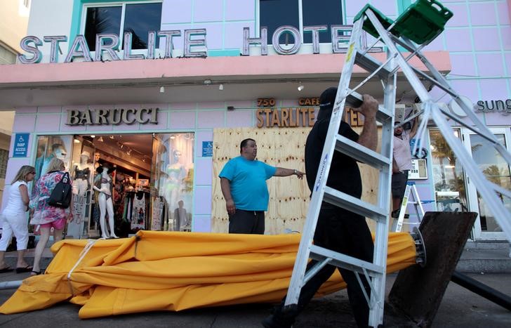
Workers remove umbrellas at the Starlite Hotel in anticipation of Hurricane Matthew in South Beach, Florida,

Workers remove umbrellas at the Starlite Hotel in anticipation of Hurricane Matthew in South Beach, Florida, U.S. October 5, 2016. REUTERS/Javier Galeano

Florida Governor Rick Scott urged those in vulnerable areas to evacuate early, even if orders had not yet been issued, and to use state shelters.

Scott requested that Obama declare a pre-landfall emergency for Florida, which would bring federal resources such as food, water and tarps, and added an additional 1,500 National Guard members to an already active force of 1,500.

Evacuations, some of them mandatory, were underway in about a dozen of Florida’s coastal counties, and at least four hospitals were being cleared, Scott said. More than 1.5 million Florida residents reside in evacuation zones, Scott’s office said.

“If it turns at the last minute, you are not going to have time to get ready,” Scott said. “You are going to put your life and your family’s life at risk.”

In South Carolina, where the effects of the storm were expected on Saturday morning, drivers reported gridlock and  long delays. The city of Charleston handed out sandbags and shovels.

Some gasoline stations posted “out of gas” signs but state officials said they were unaware of any significant shortages.

Lynn Pagliaro, 76, was filling up extra cans of gasoline and loading them into his sport utility vehicle in Charleston, saying he had no choice but to head inland.

“I live at (a retirement community) and they’re shutting off the power,” he said. “I like to get out of town anyway and take the burden off local resources. I was here for Hurricane Hugo. It made a last-minute turn.”

Hugo, a more powerful Category 4 hurricane, slammed into Charleston in September 1989, killing 21 people and causing $7 billion worth of damage on the U.S. mainland, the hurricane center said.

In Miami, the owner of an Exxon gas station in the Brickell district set up cones to form an orderly line of cars that at times stretched an entire block.

“Everybody is filling up. We’re about to run out of gas,” said Jesus Ramirez, 56.

At a nearby Publix supermarket, staff said trade was brisk with customers buying water and canned goods, concerned they might be stuck at home for days. “It’s chaos,” said one employee, who was not authorized to speak to reporters.

Floridians on social media said they were stocking up on groceries and preparing their homes with hurricane shutters.

“The grocery store shelves are practically empty,” said Facebook user Sonja Smith of Boca Raton, Florida.

American Airlines said it was canceling Thursday flights at three south Florida airports and all Friday afternoon flights in and out of Jacksonville.

(Additional reporting by Letitia Stein and Amy Tennery; Editing by Daniel Trotta, Tom Brown and Lisa Shumaker)

Coastal Florida and S. Carolina urged to evacuate as Matthew takes aim

People line up to fill their cars with gas in anticipation of Hurricane Matthew, in Coral Springs, Florida,

By Letitia Stein and Harriet McLeod

TAMPA, Fla./CHARLESTON, S.C. (Reuters) – Millions of people along the U.S. Southeast coast were urged on Wednesday to evacuate and prepare for Hurricane Matthew as the potentially devastating storm took aim at Florida and South Carolina.

Matthew, currently pummeling the Bahamas, was forecast to begin lashing Florida with fierce winds, storm surges and heavy rain late on Thursday, the U.S. National Hurricane Center (NHC) said. It has the potential to be the first major hurricane to make landfall in the United States since Wilma in 2005.

Governor Rick Scott urged those in vulnerable areas to evacuate early, even if orders had not yet been issued.

“We must prepare to be hit by a devastating hurricane,” Scott told a news conference, noting that a small wobble in Matthew’s path could hugely impact the state.

The governors in Florida, South Carolina, North Carolina and Georgia have all declared states of emergencies.

Matthew, currently a major Category Three storm, was carrying maximum sustained winds around 120 mph (195 kph) on Wednesday morning, according to the Miami-based NHC.

It was likely to strengthen slightly in the coming days, the NHC added, saying it was too soon to predict where Matthew was likely to do the most damage.

“When a hurricane is forecast to take a track roughly parallel to a coastline, as Matthew is forecast to do from Florida through South Carolina, it becomes very difficult to specify impacts at any one location,” the NHC said in an advisory.

“Only a small deviation of the track to the left of the NHC forecast could bring the core of a major hurricane onshore within the hurricane warning area in Florida. However, a small deviation to the right could keep the hurricane-force winds offshore,” it said.

Florida’s governor activated an additional 300 members of the state National Guard on Wednesday, adding to 200 already summoned the day before.

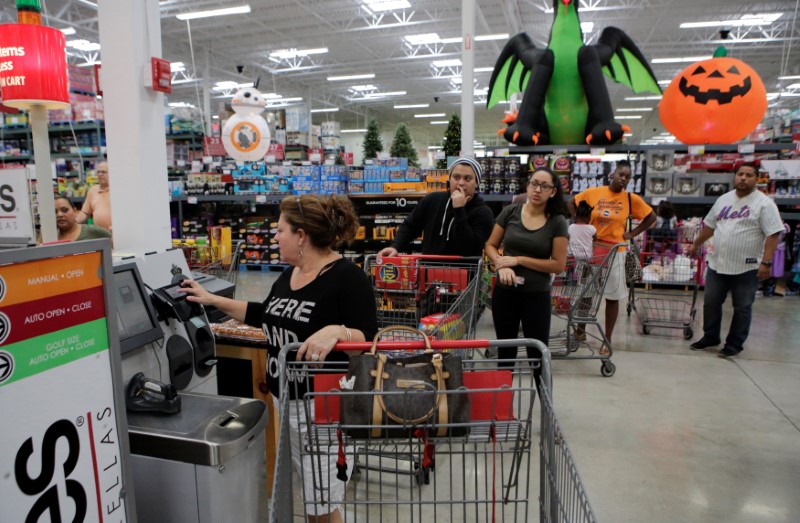
People queue as they flock to the supermarket to take care of last minute shopping in anticipation of Hurricane Matthew, in Coral Springs, Florida,

People queue as they flock to the supermarket to take care of last minute shopping in anticipation of Hurricane Matthew, in Coral Springs, Florida, U.S. October 5, 2016. REUTERS/Henry Romero

Several school districts had canceled classes for Thursday and Friday, and some were releasing students early on Wednesday.

In South Carolina, about a quarter of a million residents were expected to evacuate from coastal areas.

“If you do not leave, you are putting a National Guardsmen’s or a law enforcement officer’s life on the line,” Governor Nikki Haley said.

As thousands began to evacuate vulnerable areas in South Carolina on Wednesday, drivers reported gridlock delaying traffic for hours. Schools and county government offices in 26 of the state’s 46 counties closed through Friday.

The city of Charleston handed out sandbags and shovels. Gasoline stations in the area posted “out of gas” signs as cars lined up to fill up the tank, but state officials said they know of no significant shortages.

The judge overseeing the murder trial of a Georgia father accused of intentionally leaving his toddler son in a hot car to die in 2014 canceled court for Thursday afternoon and Friday due to the storm.

(Editing by Colleen Jenkins and Tom Brown)

Hurricane Matthew hits Haiti, heads for Cuba and then U.S.

Hurricane Matthew is seen in the Caribbean Sea in this enhanced infrared image from NOAA's GOES-East satellite

By Makini Brice

LES CAYES, Haiti (Reuters) – The fiercest Caribbean storm in almost a decade slammed Haiti on Tuesday with 145 mile-per-hour (230 kph) winds and surging seas that flooded coastal towns, killing at least one person and tearing at trees and rooftops before moving out to sea.

The eye of the violent and slow-moving Category 4 Hurricane Matthew passed over the western tip of Haiti, the U.S. National Hurricane Center said, bringing devastating winds, torrential rains and a storm surge with massive waves. The storm was forecast to remain powerful as it made its way to Cuba and the Bahamas.

A hurricane watch was issued for parts of southeast Florida, which the forecasters said Matthew could reach late on Thursday.

Haitian port town Les Cayes, named for the sandy islands off its shore and twice destroyed by hurricanes in the 18th century, was hard hit.

“The situation in Les Cayes is catastrophic, the city is flooded, you have trees lying in different places and you can barely move around, the wind has damaged many houses and taken away their rooftops,” said Deputy Mayor Marie Claudette Regis Delerme, speaking from the town of about 70,000 people.

Regis Delerme said she herself had to flee from a building where she was attending a meeting about the storm, when a gust of wind ripped the roof off.

“It is very difficult to even try to help those who need assistance right now, and we lack financial means to do so,” she said.

One man died as the storm crashed through his home in the nearby beach town of Port Salut, Haiti’s civil protection service said. He had been too sick to leave for a shelter, officials said. A fisherman was killed in heavy seas over the weekend as the storm approached, and another was missing.

There was no immediate word on other potential casualties in the poorest country in the Americas.

RUNNING FOR COVER

Overnight, Haitians living in vulnerable coastal shacks on the western Tiburon Peninsula frantically sought shelter as Matthew closed in. Several districts in southern Haiti were flooded, with crops inundated with ocean and rain water.

As much as 3 feet (1 meter) of rain was forecast to fall over hills that are largely deforested and prone to flash floods and mudslides, threatening villages as well as shantytowns in the capital Port-au-Prince, where heavy rain fell overnight.

The hurricane comes at a time when tens of thousands of people are still living in flimsy tents and makeshift dwellings in Haiti after a 2010 earthquake that killed more than 200,000 people.

More than 9,000 people were huddled in shelters across Haiti, authorities said as the eye of the storm passed over the remote fishing town of Les Anglais.

Life-threatening flash floods and mudslides were likely in southern and northwestern Haiti, the hurricane center said. It expected Matthew to remain a powerful hurricane through at least Wednesday night.

The outer bands of the storm reached the area late on Monday, flooding dozens of houses in Les Anglais when the ocean rose, the mayor said.

In the nearby town of Tiburon, the mayor said people who had been reluctant to leave their homes also ran for cover when the sea rose and large waves began hitting the town.

Matthew was 35 miles (60 km) north of Haiti and 90 miles (145 km) south of the eastern tip of Cuba at 11 a.m. EDT (1500 GMT). It was moving north at about 10 miles per hour (17 kph), the hurricane center said.

Cuba’s Communist government traditionally puts extensive efforts into saving lives and property in the face of storms, and authorities have spent days organizing teams of volunteers to move residents to safety and secure property.

The storm is expected to make a hit later on Tuesday in the province of Guantanamo, which is home to the disputed U.S. Naval base and military prison and also to a small Cuban city. The U.S. Navy ordered the evacuation of 700 spouses and children of service personnel as the storm approached.

Guantanamo’s mountainous terrain is the country’s second coffee producer after nearby Santiago, and the storm poses a major threat to the current harvest.

Haiti is due to hold a long-delayed presidential election on Oct. 9. The office of Interim President Jocelerme Privet said there was no change to the election date.

A hurricane watch was in effect from Deerfield Beach, Florida to the Volusia-Brevard county line, a coastal area near Cape Canaveral, which the storm could reach on Thursday, the hurricane center said.

“Direct hurricane impacts are possible in Florida,” the center said. It added that tropical storm or hurricane conditions could also affect parts of Georgia, South Carolina, and North Carolina later this week, even if the center of Matthew remained offshore.

Governor Rick Scott declared a state of emergency for Florida on Monday, designating resources for evacuations and shelters and putting the National Guard on standby.

(Reporting by Joseph Guyler Delva in Port-au-Prince and Makini Brice in Les Cayes; Additional reporting by Marc Frank and Sarah Marsh in Cuba and Brendan O’Brien in Milwaukee; Writing by Frank Jack Daniel; Editing by Frances Kerry and Tom Brown)

Florida declares neighborhood Zika free; CDC remains cautious

Florida Gov. Rick Scott speaks at a press conference about the Zika virus in Doral, Florida,

By Julie Steenhuysen and Ransdell Pierson

(Reuters) – U.S. health officials on Monday continued to advise pregnant women and their partners to consider postponing non-essential travel to Miami to avoid the risk of exposure to Zika, even as Florida Governor Rick Scott declared the city’s Wynwood neighborhood Zika-free and invited visitors to return.

The U.S. Centers for Disease Control and Prevention said in a statement that the Wynwood neighborhood of Miami had been considered an area of active Zika virus transmission from June 15 to Sept. 18, 2016. It urged pregnant women who lived in or traveled to the neighborhood to consider getting tested for Zika.

“We want to continue to emphasize to pregnant women that they still should consider postponing non-essential travel for all of Miami-Dade (County). That is still in effect,” said CDC spokesman Tom Skinner.

Wynwood is the first neighborhood in the continental United States to have a local outbreak of Zika, a mosquito-borne virus that has been shown to cause birth defects.

Florida’s governor, at a news conference earlier on Monday, said there have not been any cases of Zika in the Wynwood neighborhood in the past 45 days, and declared that “everybody should be coming back here and enjoying themselves.”

“We had an issue, everybody took it seriously and we solved it,” he said.

Scott’s pronouncement followed news on Friday that the state had expanded the zone with active Zika transmission to nearby Miami Beach after five new cases of the virus were detected.

The Zika zone in Miami Beach, a popular tourist destination, tripled in size, growing from 1.5 square miles to 4.5 square miles. As of Friday, Florida has a total of 93 cases of Zika caused by local mosquitoes.

Zika is a particular threat to pregnant women because the virus can cause serious birth defects in babies whose mothers were infected during pregnancy, including microcephaly, a condition in which the brain is undersized, reflecting arrested development.

Scott also called on the U.S. government to approve spending to arrest any future spread of the virus in Florida and elsewhere, including funds for mosquito abatement, education and testing for Zika. A spending bill has been delayed in Congress.

(Reporting by Colleen Jenkins, Julie Steenhuysen and Ransdell Pierson; Editing by Dan Grebler)

Hermine lingers off U.S. East Coast

A woman walks her dog at Rockaway Beach in Queens, New York on Labor Day while high waves reached the shore due to post-tropical cyclone Hermine which tracked off the east coast of the U.S.

Reuters) – Hermine, a storm that raked Florida with hurricane-force winds last week, lingered on Tuesday off the U.S. East Coast where it was expected to produce heavy gusts and rain over the next two days.

Forecasters warned swimmers and boaters to stay out of treacherous waters and rough surf. New York City said all public beaches would be closed through Tuesday because of “life-threatening” rip currents.

At 2 a.m. EDT on Tuesday, Hermine’s center was about 110 miles (175 km) southeast of the eastern tip of Long Island and expected to move northwest at about 9 mph (15 kph).

Hermine was forecast to bring up to 2 inches (5 cm) of rain to Rhode Island and southern Massachusetts through Wednesday, the National Weather Service said.

A tropical storm warning remained in effect from the eastern end of New York’s Long Island and to Martha’s Vineyard and Nantucket Island off Massachusetts.

On Cape Cod and its islands, high surf and wind put a crimp in the Labor Day plans of many people looking to celebrate summer’s end, but some beaches farther south reopened.

Hermine was classified as a Category 1 hurricane when it slammed into Florida’s Gulf Coast on Friday. It became a post-tropical storm by week’s end after its winds dropped below 74 miles per hour (119 kph) and it lost its tropical characteristics.

The storm, which crossed northern Florida and then moved up the Georgia and the Carolina coasts, was packing sustained surface winds of up to 65 mph (100 kph) with higher gusts, the National Weather Service said.

“Just because it’s a post-tropical cyclone doesn’t mean the impact of tropical force winds, winds in general and storm surge go away,” said National Hurricane Center spokesman Dennis Feltgen.

The storm has claimed at least three lives, in Florida and in North and South Carolina. The third reported death was that of a man struck by a car on a South Carolina highway on Friday as he tried to move a fallen tree, a Colleton County fire department spokesman said.

Hermine became the first hurricane to make landfall in Florida in 11 years, packing winds of 80 mph (130 kph), and knocking out power to 300,000 homes and businesses.

(Reporting by Brendan O’Brien in Milwaukee)

Lurking Hermine spares much of U.S. East Coast, could regain hurricane strength

Tropical Storm Hermine is pictured off the coast of the U.S. Mid-Atlantic

By Daniel Trotta and Chris Prentice

NEW YORK (Reuters) – Atlantic storm Hermine, which has killed two people, lurked off the middle of the U.S. East Coast late on Sunday while threatening to regain hurricane strength, after having spared the region the brunt of its wind, rain and tidal surge.

Forecasters warned swimmers and boaters to avoid the risk of deadly surf churned up by the storm and stay out of treacherous waters during the Labor Day holiday weekend, when many Americans celebrate the end of summer.

Hermine was still packing maximum sustained surface winds of nearly 70 mph (113 kph) late on Sunday, and forecasters said it  could intensify slightly to reach hurricane strength again, before it starts to dwindle later on Monday.

But for now, its strongest winds were extending outward by about 230 miles (370 km), failing to reach U.S. shores.

Hermine was forecast to bring up to 2 inches (5 cm) of rain to southern New England on Monday, after having hit land in Florida on Friday, and churning up the southeastern seaboard.

Sandbags and tarps cover the entrance to a subway station near Battery Park as New York City prepares for potential flooding as post-tropical storm Hermine stalls off the east coast of the United States

Sandbags and tarps cover the entrance to a subway station near Battery Park as New York City prepares for potential flooding as post-tropical storm Hermine stalls off the east coast of the United States, September 4, 2016. REUTERS/Mark Kauzlarich

Then it merged with a conventional weather front, to be reclassified on Saturday as a post-tropical cyclone.

But Hermine was not expected to make landfall again, said Robbie Berg, an official of the National Hurricane Center.

A tropical storm warning remained in effect Sunday night from the Delaware and New Jersey shores north to New York’s Long Island and beyond to Martha’s Vineyard and Nantucket Island off Massachusetts, but was canceled for New York City, which Berg said appeared largely out of harm’s way.

Potential storm-surge inundation levels of no more than 1 to 3 feet (30 cm to 1 m) were expected in coastal areas.

As the threat to New Jersey waned, Governor Chris Christie ordered Island Beach State Park reopened for Monday, while warning that lingering rip currents and rough surf might still make the ocean unsafe for swimmers.

At 11 p.m. EDT on Sunday, Hermine’s center was about 325 miles (523 km) southeast of Long Island, the eastern tip of New York, the hurricane center said.

It was expected to “meander slowly” off the mid-Atlantic region, moving north-northeast at only 3 mph (5 kph) and stay at least 300 miles (480 km) from shore before beginning to weaken by Monday night, the agency said.

WANING STORM THREAT BEYOND COAST

The storm claimed at least two lives, in Florida and North Carolina, but the widespread power outages and flooding that battered Florida, Georgia and the Carolinas had yet to materialize farther north, where alarming news reports scared many tourists away from the beach on Sunday.

Those who stayed awoke to sunshine, but stronger-than-usual winds and choppy seas.

“It was a little overhyped by the media,” said Andrew Thulin, assistant general manager of Daddy O Hotel Restaurant in the New Jersey township of Long Beach.

“It killed the weekend for everybody down here.”

Officials mindful of the 2012 devastation of Superstorm Sandy took every precaution. Elsewhere in the state coastal roads were reported flooded, and beaches engulfed by the sea.

Hermine became the first hurricane to make landfall in Florida in 11 years, packing winds of 80 mph (129 kph), and knocking out power to 300,000 homes and businesses. Downgraded to a tropical storm within hours, it still packed a wallop.

(Additional reporting by Steve Gorman from Los Angeles and Chris Michaud from New York)

Tropical Storm Hermine pounds into the Carolinas

Three storm systems are shown (L TO R) Tropical Depression Nine to the southeast of Florida,

By Letitia Stein

TAMPA, Fla., Sept 2 (Reuters) – Hurricane Hermine wreaked havoc across Florida on Friday, causing widespread power outages and flooding before diminishing into a tropical storm and plowing up the Atlantic Coast into the Carolinas with a still-potent mix of high winds and heavy rains.

The first hurricane to make landfall in Florida in 11 years Hermine swept ashore early on Friday near the Gulf shore town of St. Marks, 20 miles (30 km) south of the capital of Tallahassee, packing winds of 80 mph (130 kph) and churning up a devastating storm surge in coastal areas.

Torrential downpours and high surf left parts of some communities under water early Friday, with mandatory evacuations ordered in parts of five northwestern Florida counties.

State officials said electricity had been knocked out to nearly 300,000 homes and businesses by afternoon.

One storm-related death was reported by authorities in the northern Florida town of Ocala, where a fallen tree killed a homeless man sleeping in his tent.

Hermine was expected to snarl Labor Day holiday travel as it churned northeast for several more days after battering Florida’s $89 billion tourism industry.

While maximum sustained winds had weakened to 50 mph (80 kph), the tempest headed to the Atlantic seaboard along a path inhabited by tens of millions of Americans, prompting storm
watches and warnings as far north as Rhode Island.

As of 9 p.m. EDT (0100 GMT), the fourth named storm of the 2016 Atlantic hurricane season was passing near Myrtle Beach, South Carolina, leaving some 51,000 power outages across the state, said state emergency management spokesman Derrec Becker.

Becker said localized flooding hit low-lying areas across the state, and there were widespread reports of “downed power lines, downed trees, trees on cars and some flooded cars,” along with isolated incidents of tree-damaged homes.

One mobile home was virtually sliced in two by a fallen tree, but authorities had no reports of serious storm-related injuries or fatalities, Becker added.

Likewise, emergency officials reported no storm deaths in Georgia, which Hermine swept through on its way to South Carolina, but said at least 100,000 utility customers were
without power at one point.

Emergency declarations remained in effect for all or parts of Florida, Georgia, North Carolina, Virginia and Maryland.

LIKELY TO REGAIN STRENGTH

The storm was projected to creep north along the Carolina coast Friday night, then gather strength after moving offshore into the Atlantic on Saturday morning, possibly reaching near-hurricane intensity by late Sunday, according to the National Hurricane Center.

In addition to powerful winds extending up to 185 miles (295 km) from its center, Hermine was expected to unleash a dangerous storm surge in the Hampton Roads area of tidewater Virginia, where flooding could become 3 to 5 feet deep, the NHC warned.

The storm also could douse several southeastern and mid-Atlantic states with up to 15 inches (38 cm) of rain through Sunday, the agency said.

New Jersey, still mindful of devastation from superstorm Sandy in 2012, was on high alert as emergency officials advised residents to prepare for flooding, high winds and a surge of
seawater.

New York Governor Andrew Cuomo on Friday activated his state’s emergency operations center and ordered officials to stockpile resources, including sandbags and generators.

New York City Mayor Bill De Blasio said residents should avoid beach waters for fear of life-threatening riptides. “I say that to people who go the beach, I say that to surfers: Don’t even think about it,” De Blasio told reporters.

In Florida, concerns over the standing water in which mosquitoes breed intensified as the state battled an outbreak of the Zika virus.

“It is incredibly important that everyone does their part to combat the Zika virus by dumping standing water, no matter how small,” Florida Governor Rick Scott told a news conference.

Overnight, crews in Pasco County, Florida, rescued more than a dozen people after their homes were flooded.

Richard Jewett, 68, was rescued from his home in New PortRichey, just north of Tampa, as emergency teams carried out amandatory evacuation.

“The canal started creeping up toward the house, and even though it wasn’t high tide it looked like it was coming inside,” Jewett said.

(Additional reporting by Zachary Fagenson in Hudson Beach,
Fla., Steve Gorman in Los Angeles, Brendan O’Brien in Milwaukee,
Laila Kearney in New York and Jon Herskovitz in Austin; Editing
by Daniel Trotta and Cynthia Osterman)

Hermine tears through Florida, raises new Zika fears

Robert Long and his son J.D. watch workers removing downed trees during cleanup operations in the aftermath of Hurricane Hermine in Tallahassee

By Letitia Stein

TAMPA, Fla. (Reuters) – Hurricane Hermine tore a path of destruction across Florida on Friday, knocking out power for 253,000 customers, flooding low-lying areas and raising concerns about the spread of the Zika virus from pools of standing water left behind.

The first hurricane to make landfall in Florida in more than a decade, Hermine came ashore early on Friday near St. Marks, Florida, 20 miles (30 km) south of the capital of Tallahassee, packing winds of 80 mph (130 kph) and churning up a devastating storm surge in coastal areas.

Hermine, which has since been downgraded to a tropical storm, was set to snarl U.S. Labor Day holiday travel as it moves northeast after battering Florida’s $89 billion tourism industry.

The storm center was on the border between Georgia and South Carolina at 2 p.m.(1800 GMT), the National Hurricane Center (NHC) said.

A huge pine tree is shown after falling through a home from the wind and rain damage of Hurricane Hermine in Tallahassee, Florida

A huge pine tree is shown after falling through a home from the wind and rain damage of Hurricane Hermine in Tallahassee, Florida September 2, 2016. REUTERS/Phil Sears REUTERS/Phil Sears


Though sustained winds had weakened to 50 mph (80 kph), the tempest headed toward the Atlantic seaboard on a path where tens of millions of Americans live, causing storm watches and warnings stretching to Rhode Island, NHC said.

It could strengthen again over water and possibly bring up to 15 inches (38 cm) of rain to the southeastern and mid-Atlantic states over the next 48 hours, with heavy rainfall possibly hitting coastal Delaware and New Jersey starting on Saturday night, the center said.

New Jersey, still mindful of the devastation caused by Hurricane Sandy in 2012, was on high alert as emergency officials advised people to prepare for flooding, high winds and a surge of seawater.

New York Governor Andrew Cuomo on Friday activated his state’s emergency operations center and advised emergency officials to stockpile resources, including sandbags and generators.

As it tracks north offshore towards New York, the storm is projected to stall at sea through Wednesday morning, the National Hurricane Center said.

New York Mayor Bill De Blasio said residents should avoid beach waters for fear of life-threatening riptides caused by the lingering storm. “I say that to people who go the beach, I say that to surfers: Don’t even think about it,” De Blasio told a news conference.

WORRIES ABOUT ZIKA

In Florida, concerns over the standing water in which mosquitoes breed intensified as the state battles an outbreak of the Zika virus.

“It is incredibly important that everyone does their part to combat the Zika virus by dumping standing water, no matter how small,” Florida Governor Rick Scott told a news conference, also warning people to look for downed power lines and avoid driving in standing water pools.

There have been 47 cases of Zika in people believed to have contracted the virus through local mosquitoes, according to the Florida Department of Health. Active transmission is thought to be occurring in two small areas around Miami.

As the sun rose on Friday morning on Hudson Beach, just north of Tampa, cars sat askew in flooded roads. Palm fronds, tree branches and garbage cans were scattered about.

Overnight, Pasco County crews rescued more than a dozen people after their homes were flooded.

Richard Jewett, 68, was rescued from his home in New Port Richey, just north of Tampa, around 1:30 a.m. EDT (0530 GMT) as emergency workers carried out a mandatory evacuation.

“The canal started creeping up toward the house and even though it wasn’t high tide it looked like it was coming inside,” Jewett said.

In Cedar Key, an island community in northwest Florida, waters rose more than 9.5 feet (2.9 meters), among the highest surges ever seen, the National Weather Service said.

“This is one of the worst that we have seen in the city in a long time, and unfortunately, it is not over yet,” St. Petersburg, Florida, Mayor Rick Kriseman told reporters.

(Additional reporting by Zachary Fagenson in Hudson Beach, Fla., Brendan O’Brien in Milwaukee, Laila Kearney in New York and Jon Herskovitz in Austin; Editing by Daniel Trotta and Cynthia Osterman)

Hermine hammers Florida, leaving thousands without power

Three storm systems

(Updates with Hermine being downgraded to tropical storm)

By Letitia Stein

TAMPA, Fla., Sept 2 (Reuters) – Wind and rain from Hurricane
Hermine slammed Florida’s northern Gulf Coast before it weakened
to a tropical storm and ploughed its way overland towards the
Atlantic Coast on Friday.

Hermine made landfall early on Friday, bringing heavy rains
and packing winds of 80 mph (130 km/h), causing damage and
leaving tens of thousands of households without power along
Florida’s Gulf Coast.

“It is a mess…we have high water in numerous places,”
Virgil Sandlin, the police chief in Cedar Key, Florida, told the
Weather Channel.

Strong gusts downed power lines and trees as widespread
flooding inundated communities in Florida before the hurricane
weakened into a tropical storm as it reached Georgia and South
Carolina, where conditions deteriorated early on Friday morning.

“The combination of a dangerous storm surge and the tide
will continue to cause normally dry areas near the coast to be
flooded by rising waters moving inland from the shoreline,”
the National Hurricane Center said.

The center warned that some areas along Florida’s northern
Gulf Coast may experience 9 feet (3 m) of flooding.

Florida Governor Rick Scott said the storm could lead to
deaths and told residents to stay indoors until it had passed.

Pasco County reported crews rescued 18 people and brought
them to shelters after their homes were flooded in Green Key and
Hudson Beach early on Friday.

“Stay indoors even if it calm outside. The eye of Hermine
may be passing through. Let it pass completely before surveying
any damage,” Governor Scott advised residents in a Twitter post.

Hermine became the fourth hurricane of the 2016 Atlantic
storm season. By 11 p.m. EDT, maximum winds were listed at 80
mph (130 kph), with hurricane-force winds extending up to 45
miles (75 km) from the storm’s center.

Hermine could dump as much as 20 inches (51 cm) of rain in
some parts of the state. Ocean storm surge could swell as high
as 12 feet (3.6 meters).

Scott declared a state of emergency in 51 of Florida’s 67
counties, and at least 20 counties closed schools.

Mandatory evacuations were ordered in parts of five counties
in northwestern Florida, with voluntary evacuations in at least
three more counties. Twenty emergency shelters were opened
across the state for those displaced by the storm.

“This is life-threatening,” Scott told reporters on
Thursday.

In coastal Franklin County, people were evacuated from
barrier islands and low-lying shore areas.

“Those on higher ground are stocking up and hunkering down,”
Pamela Brownlee, the county’s emergency management director,
said.

The National Weather Service issued tornado and tropical
storm watches and warnings for communities throughout northern
Florida and north along Atlantic Coast, where it posed a Labor
Day weekend threat for tens of millions of people.

On its current path, the storm also could dump as much as 10
inches (25 cm) of rain on coastal areas of Georgia, which was
under a tropical storm watch, and the Carolinas. Forecasters
warned of “life-threatening” floods and flash floods there.

The governors of Georgia and North Carolina on Thursday
declared emergencies in affected regions. In South Carolina, the
low-lying coastal city of Charleston was handing out sandbags.

(Additional reporting by Brendan O’Brien in Milwaukee, Laila
Kearney in New York and Jon Herskovitz in Austin, Editing by
Angus MacSwan)

Hurricane warning issued for parts of Florida; Madeline weakens

A city worker fills sandbags to help residents prepare for an expected tropical storm in Gulfport, Florida

TAMPA BAY, Fla. (Reuters) – Forecasters and public officials urged Floridians to prepare for potentially catastrophic flooding and damaging winds as Tropical Storm Hermine was expected to become a hurricane by the time it reached Florida’s northern Gulf Coast on Thursday.

A hurricane warning was in effect for the Florida panhandle from the Suwannee River to Mexico Beach as the strengthening storm was expected to sweep across northern parts of the state and then northeast along the Atlantic Coast, the National Hurricane Center said in an advisory.

The forecast of rough weather prompted Florida Governor Rick Scott to declare an emergency on Wednesday as many school districts along the Gulf Coast canceled after-school activities and ordered students to stay home on Thursday.

Cities such as Tallahassee and Orlando were offering sandbags to residents to protect homes and businesses from flooding caused by the up to 10 inches (25 cm) of rain as heavy rains were already pounding parts of the state and were expected through Friday.

“There is a danger of life-threatening inundation,” said the center’s advisory that noted the possibility of as much as 20 inches (20 cm) of rain to fall in some isolated areas and life-threatening flash flooding.

The storm, packing winds of 60 mph (95 kmh) with higher gusts, was expected to get stronger by the time it reach landfall, making outside preparations difficult or dangerous, the center said.

“Heavy rainfall and strong winds will make driving dangerous. Even after the storm passes, citizens should avoid unnecessary travel to allow first responders and road clearing crews to quickly respond to emergency needs,” the City of Tallahassee said in an alert to residents.

Three storm systems are shown (L TO R) Tropical Depression Nine to the southeast of Florida, Tropical Depression Eight just off the coast of the Carolinas and Hurricane Gaston in the central Atlantic Ocean are shown in this GOES East satellite image captured August 29, 2016. NOAA/handout via REUTERS

Three storm systems are shown (L TO R) Tropical Depression Nine to the southeast of Florida, Tropical Depression Eight just off the coast of the Carolinas and Hurricane Gaston in the central Atlantic Ocean are shown in this GOES East satellite image captured August 29, 2016. NOAA/handout via REUTERS

On its current path, the system would also dump as much as 10 inches (25 cm) of rain on coastal areas of Georgia, which was under a tropical storm watch, and the Carolinas.

A tropical storm warning was also issued for the U.S. east coast from Marineland, Florida to South Santee River, South Carolina, the Miami-based weather forecaster said.

U.S. oil and gas producers in the east of the Gulf of Mexico removed workers from 10 offshore platforms, moved drilling rigs and shut some output because of the storm.

The hurricane center also said in an advisory that the center of Hurricane Gaston will move near the Azores on Friday.

Meantime, Hurricane Madeline weakened to a tropical storm as it passed south of Hawaii’s Big Island, where officials opened shelters and closed offices, schools and roads on Wednesday.

The tropical storm, before it moves westward out of reach of Hawaii, was expected to dump as much as 15 inches (40 cm) of rain on parts of the Big Island, according to the National Weather Service.

Hurricane Lester, currently a major Category 4 storm, could affect Hawaii over the weekend.

Hawaii Governor David Ige signed an emergency proclamation that runs through Sept. 9, freeing up state resources.

(Reporting by Brendan O’Brien in Milwaukee; Editing by Toby Chopra)