Tropical Storm Emily weakens as it crosses central Florida

Tropical Storm Emily is shown over the west coast of Florida in this satellite image taken July 31, 2017. Courtesy NOAA GOES/Handout via REUTERS

By Bernie Woodall

FORT LAUDERDALE, Fla. (Reuters) – Tropical Storm Emily dumped heavy rain over much of Florida on Monday but caused no injuries or major property damage as it moved eastward across the state, the National Hurricane Center and state officials said.

Emily was expected to weaken to a tropical depression before it enters the Atlantic Ocean early Tuesday morning, according to the Miami-based hurricane center.

Emily, the fifth named storm of the 2017 Atlantic hurricane season, made landfall Monday morning on Anna Maria Island near the Tampa-St. Petersburg area and moved across the central part of the state.

At 2 p.m. ET (1800 GMT), the storm had maximum sustained winds of 40 miles per hour (64 kph), down from 45 mph (72 kph) three hours earlier.

Several school districts curtailed summer programs and the Sunshine Skyway Bridge over Tampa Bay, part of a major north-south interstate freeway, was closed for several hours because of high winds.

Florida Governor Rick Scott declared a state of emergency in 31 of the state’s 67 counties to allow for easier cooperation between agencies. By mid-afternoon, no evacuation orders had been given, Scott said at a press conference.

Along Florida’s west coast from the Tampa-St. Petersburg area south to Naples, rainfall of 2 to 4 (5 to 10 inches) was expected, with isolated areas getting as much as 8 inches (20 cm), the National Hurricane Center said. Other areas in southern and central Florida were to get 1 to 2 inches of rain, it said.

(Reporting by Bernie Woodall in Fort Lauderdale, Fla., Jonathan Allen in New York and Eileen Soreng in Bengaluru; Editing by Grant McCool and James Dalgleish)

Sri Lanka landslides, floods kill at least 25; dozens missing

Military officials work during a rescue mission at the site of a landslide in Bellana village in Kalutara, Sri Lanka May 26, 2017. REUTERS/Dinuka Liyanawatte

COLOMBO (Reuters) – Floods and landslides in Sri Lanka have killed at least 25 people while dozens are missing after torrential rain, officials said on Friday, as soldiers fanned out in boats and in helicopters to help with rescue operations.

The early rainy season downpours have forced hundreds of people from their homes across the Indian Ocean island.

“There are at least five landslides reported in several places in Kaluthara,” said police spokesman Priyantha Jayakody, referring to the worst-hit district on the island’s west coast.

“Rescue operations are still taking place.”

The disaster management center said 25 people had been killed and 42 were missing.

Military Spokesman Roshan Senevirathne said about 400 military personnel had been deployed with boats and helicopters to help the police and civilian agencies.

The wettest time of the year in Sri Lanka is usually during the southern monsoon, from May to September.

(Reporting by Ranga Sirilal and Shihar Aneez; Editing by Robert Birsel)

Heavy rain, wind disrupts travel for New Yorkers

A motorcycle is seen in water on the West Side Highway after heavy rain in the Manhattan borough of New York, U.S., May 5, 2017.REUTERS/Carlo Allegri

By Peter Szekely

NEW YORK (Reuters) – Heavy, wind-driven rain soaked the New York City area on Friday afternoon, causing local flooding and an array of transportation delays across the heavily populated region.

The National Weather Service issued flash flood warnings for much of New York City and several suburban counties as a weather system that stretched across much of the Eastern Seaboard dumped three inches of rain on the metropolitan region in three hours.

The rain forced the closure of Manhattan’s West Side Highway, a major thoroughfare along the Hudson River, for at least 10 blocks, and caused extensive traffic delays citywide, New York City’s Office of Emergency Management said.

While the intensity of rainfall had diminished shortly before the evening rush hour, water in flood-affected areas was expected to take several hours to recede.

The weather service received reports of flooding across all five boroughs of New York City, prompting some vehicle rescues, spokesman Tim Morrin said.

“The problem was the rain came down so heavy and so fast that the drainage couldn’t keep up,” Morrin said. “Roads became quickly impassible.”

Many flights in and out of New York airports experienced long delays and there were many cancellations. Hardest hit was LaGuardia Airport, where more than 34 percent of departing flights were delayed and 14 percent canceled, according to FlightAware, a website that tracks air travel.

The PATH rail service that connects New Jersey to Manhattan suspended service on two lines on Friday, citing a power problem.

Flooding forced the temporary closure of the main entrance to Manhattan’s Pennsylvania Station, according to local media. The reports could not be immediately confirmed by Reuters.

The weather-related disruption was especially aggravating for commuters from New Jersey and Long Island suburbs who have endured hours-long delays in recent weeks after derailments and other incidents at Penn Station.

Claire Jones, 19, who commutes from her home in New Jersey to New York, said her New Jersey Transit line running in and out of Penn Station was delayed at least six times this month.

“It’s difficult,” Jones said. “The main thing about time transit is that it’s convenient so you know if you get on this train at this time, you’ll get where you need to go, and when that doesn’t happen, it’s extremely inconvenient.”

Amtrak, which owns and operates New York’s Penn Station and leases tracks and space to NJ Transit and the Long Island Railroad, is planning to close some tracks for weeks and months at a time as it undertakes repairs

The station, with its decaying, century-old rail tunnels extending underneath the Hudson River, is a chokepoint on Amtrak’s Northeast Corridor, which runs from Washington to Boston.

The storm also caused inconvenience at the New York’s Oculus transportation hub in lower Manhattan, which opened only last August. Its roof began leaking, scattering hundreds of travelers, a Twitter-posted picture showed.

The Port Authority of New York and New Jersey, which operates the Oculus at the World Trade Center complex, could not immediately confirm the leak.

(Reporting by Laila Kearney, Gina Cherelus and Jonathan Allen; Writing by Peter Szekely; Editing by Leslie Adler)

Rain threatens U.S. Midwest as flooding force hundreds from homes

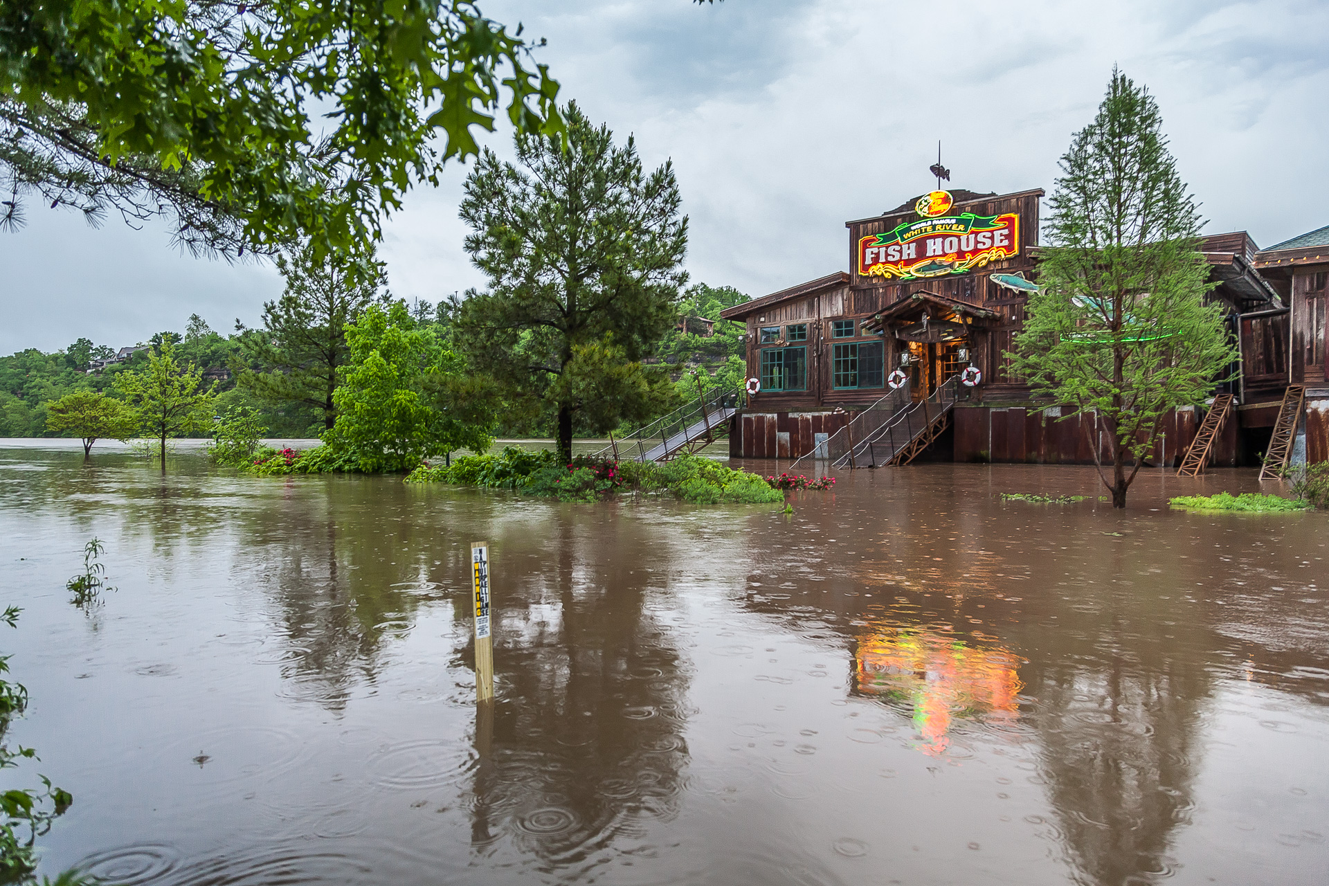
Long Creek Bridge on 86 highway, flooding Photo By Austin Metcalf

(Reuters) – Unrelenting rain will drench the already saturated U.S. Midwest on Thursday and Friday, forecasters said, after floods in the region killed at least five people and forced residents in vulnerable areas to evacuate their flooded communities.

Parts of Missouri, Illinois, Arkansas, Indiana and Oklahoma could see as much as an additional 4 inches (10 cm) of rain as a slow-moving system is expected to hover over the region for at least one more day, the National Weather Service said in flood warnings and watches.

“The flooding in the middle part of the county has been unbelievable over the last couple of days … and we have more rain on the way, if you can believe that,” Weather.com meteorologist Ari Sarsalari said during his forecast on Wednesday night.

The National Weather Service issued flash flood warnings and watches along waterways from eastern Texas north through Indiana and into northwestern Ohio as forecasters expected most of the rivers across the U.S. Midwest to crest over the weekend.

Branson Landing in Branson, Missouri. Photo by Austin Metcalf

Branson Landing in Branson, Missouri.
Photo by Austin Metcalf

The rain comes after five people were killed in flooding in Missouri, the last two of them swept from their cars on Monday and Tuesday, after a storm dumped almost 12 inches (30 cm) of rain in the region over the weekend, the National Weather Service said.

Schools throughout the Midwest canceled classes on Thursday as dozens of roadways and parts of interstate highways remained under water. Amtrak also suspended service in Missouri until at least Saturday, it said in a statement.

The heavy rains have caused levees to fail or to be breached along the Missouri, Mississippi and Ohio rivers and their tributaries over the last few days.

Hundreds of people in places like Eureka, Missouri and Pocahontas, Arkansas have heeded evacuation orders and advisories after building walls of sandbags to protect their homes and businesses from the rising waters.

(Reporting by Brendan O’Brien in Milwaukee; Editing by Toby Chopra)

Torrential rains, damaging winds on tap for U.S. midsection

Stormy weather Courtesy of Pixabay

(Reuters) – A dangerous storm front will thrash the U.S. midsection over the weekend with torrential rainfall, damaging winds and large hail that will leave behind the threat of flooding throughout the region, the National Weather Service warned.

On Friday night, thunderstorms had already clobbered several communities in the southern Midwest with winds that took down trees and power lines while a reported rain-wrapped tornado in Lawrence, Illinois damaged a house, destroyed a structure and caused power outages, the weather service said.

On Saturday, a large swath of the region – from northern Texas up through Michigan – can expect torrential downpours that will produce 7 inches (18 cm) of rain, large hail and damaging wind gusts of 60 miles (95 km) per hour, the weather service predicted.

“The widespread and very heavy rain may produce life threatening flash flooding,” the weather service said in an advisory.

Will Rogers World Airport in Oklahoma City, Oklahoma told travelers on Twitter to “expect delays” and to check their flight with their airline as severe weather moves through the area.

The region has already received about 400 percent or more of normal moisture in the last week and will be highly sensitive to additional rainfall, the service said.

Evacuations could be necessary as areas along swollen waterways could see widespread flooding as the weather service issued flood warnings and watches for the weekend and into next week.

“Be very careful if out in the flooding rain. Many road closures. Never drive through a flooded road,” tweeted Ben Pine, a meteorologist for an ABC affiliate in Louisville, Kentucky.

To the west, a winter storm was expected to dump as much as a foot of wet, heavy snow (30 cm) in parts of Colorado, New Mexico, Kansas and Texas, the National Weather Service said.

(Reporting by Brendan O’Brien in Milwaukee; Editing by Toby Chopra)

Colombia landslide kills at least 17 as rains lash Andes

View of a neighborhood destroyed after mudslides, caused by heavy rains leading several rivers to overflow, pushing sediment and rocks into buildings and roads, in Manizales, Colombia April 19, 2017. REUTERS/Santiago Osorio

BOGOTA (Reuters) – At least 17 people were killed and seven are missing after a landslide sent mud and rocks crashing into several neighborhoods in Manizales, Colombia, the government said on Wednesday, the second deadly landslide in the country this month.

Recent heavy rains have endangered residents in dozens of provincial towns, where makeshift construction on the slopes of the Andes mountains makes neighborhoods particularly susceptible to avalanches and flooding.

The landslide in Manizales, capital of coffee-growing Caldas province west of Bogota, followed a similar disaster in Mocoa, Putumayo earlier this month that killed more than 320 people and displaced thousands from their homes.

“We are helping to find the disappeared … and unfortunately the number will rise,” President Juan Manuel Santos said of the death toll after arriving in Manizales.

At least 57 houses have been affected, the government said. Local media reported that Manizales received a month’s average rainfall just overnight.

Rescuers from the Red Cross, civil defense, firefighters and armed forces are searching for the disappeared in the mud and debris of destroyed buildings.

Running water, electricity and gas services have been suspended in the areas affected by the landslides.

“The situation in Manizales is very worrying. The toll is saddening,” Transport Minister Jorge Eduardo Rojas said after meeting with the province’s governor and the mayor of the city.

The forecast is for at least another two days of rain in the area.

Even in a country where rains, a mountainous landscape and informal construction combine to make landslides a common occurrence, the scale of the Mocoa disaster far surpassed recent tragedies, including a 2015 landslide that killed nearly 100 people.

Colombia’s deadliest landslide, the 1985 Armero disaster, killed more than 20,000.

(Reporting by Julia Symmes Cobb and Helen Murphy; Editing by Phil Berlowitz)

U.S. Southeast, Midwest face threat of severe storms, potential tornadoes

Stock photo of a thunderstorm that could produce tornadoes. Courtesy of Pixabay

(Reuters) – A dangerous weather system packing severe thunderstorms was expected to roll through the U.S. Southeast and parts of the Midwest on Wednesday, bringing with it the threat of tornadoes, forecasters said.

The region faced the threat of supercells developing throughout the day as very large hail and damaging straight-line wind appear to be likely, the National Weather Service said in an advisory.

At about 5:30 a.m. local time, a thunderstorm was moving northeast of Anniston, Alabama, at 55 miles (89 km) per hour, bringing with it hail the size of golf balls and 60 mile (98 km) per hour wind gusts, the Weather Service reported.

“For your protection move to an interior room on the lowest floor of a building,” the National Weather Service warned in an advisory.

Kentucky, Tennessee, Alabama, Georgia and South Carolina faced a heightened chance of tornadoes and potential flash flooding during the day.

The 5.7 million people who live in the Atlanta metro area should expect as much as 2-1/2 inches (6 cm) of rain throughout the day and into the evening, the service said.

Dozens of school districts in Alabama and Georgia canceled classes while Alabama Governor Robert Bentley issued a state of emergency ahead of the storm front.

“Alabama is no stranger to the impact severe weather can have on communities and the devastation that can occur when the weather takes a turn for the worse,” Bentley said in a statement.

The severe weather comes days after a powerful storm system in the southeastern U.S. killed four people, including a woman who was swept away by flood waters while she called 911.

(Reporting by Brendan O’Brien; Editing by Chizu Nomiyama)

Army assesses damage after storm ‘absolutely smashes’ north Australia

A damaged building is seen behind a boat that was pushed onto a bank due to Cyclone Debbie in the township of Airlie Beach, located south of the northern Australian city of Townsville, March 29, 2017. AAP/Dan Peled/via REUTERS

By Tom Westbrook and Benjamin Weir

SYDNEY (Reuters) – Cyclone Debbie wrought widespread but moderate damage in Australia’s northeast, authorities said on Wednesday, as flooding rain and fallen trees slowed troops and emergency workers reaching the worst-hit areas.

No deaths were reported a day after Debbie smashed tourist resorts, flattened canefields and shut down coal mines in tropical Queensland state as a category four storm, one rung below the most dangerous wind speed level.

“It’s looking promising in terms of being able to rebuild promptly with most of the major infrastructure intact,” Queensland state police deputy commissioner Steve Gollschewski told Australian Broadcasting Corporation television.

“We’re still struggling to get in there, however,” he said, adding planes and boats were being used to bring army personnel and emergency workers to places cut-off by road.

And as poor weather persisted and several Bowen Basin collieries stayed shut, analysts said Debbie could push coking coal prices higher – while tourism operators, even in unaffected regions, reported canceled bookings.

Resorts along the world-famous Great Barrier Reef and coastal areas bore the brunt of the storm with wind gusts stronger than 260 kph (160 mph).

One family near Airlie Beach, over which the eye of the storm passed, had a particularly dramatic night. Queensland Premier Annastacia Palaszczuk said the family welcomed a baby girl who was born inside the Whitsunday Ambulance Station as the storm raged outside.

Pictures from Hamilton Island and Airlie Beach showed streets stacked with snapped trees, roof tiles and furniture, with wrecked yachts washed ashore.

“Nature has flung her worst at the people of Queensland,” Australian Prime Minister Malcolm Turnbull told reporters at the Crisis Coordination Centre in Canberra.

Electricity was cut for more than 63,000 people, and Wilmar said its sugar mills were stilled at Proserpine and Sarina.

Hundreds of hectares of sugarcane crops had been flattened, Dan Galligan, chief executive of industry body Canegrowers, said in a statement.

In the Bowen Basin, the world’s single-largest source of coal used to make steel, BHP Billiton, Glencore, and Stanmore Coal all said work at mines there was halted until further notice.

But Glencore added its Collinsville and Newlands mines were not damaged and it anticipated production would resume within 48 hours, with no impact on annual targets. Prices lifted, but other factors also contributed.

Ports operator North Queensland Bulk Ports Corporation also said it had no reports of significant damage.

Whitsunday Islands resorts were battered, running short on fresh water and closed to bookings until at least next week, but mostly intact.

Hoteliers hundreds of kilometers away at Cairns and Rockhampton were seeing cancellations for upcoming Easter holidays and operators worried that bad press would prolong the recovery, Queensland Tourism Industry Council chief executive Daniel Gschwind said.

“These are places that are entirely unaffected by these circumstances and that’s the kind of collateral damage we suffer sometimes in our industry,” he said.

Townsville Airport reopened, although airlines Qantas and Virgin said flights to Hamilton Island, Proserpine and Mackay were canceled.

Only two injuries were reported, police said.

(Reporting by Tom Westbrook; Writing by Jane Wardell; Editing by Toni Reinhold, Paul Tait and Michael Perry)

After weird winter, U.S. forecasters see warm, wet spring

A couple embraces in front of an ice-covered fountain in Bryant Park in New York City, U.S.

By Barbara Goldberg

NEW YORK (Reuters) – If you liked the balmy weather that dominated on the U.S. East Coast and much of the South this winter, you will probably enjoy the spring of 2017, too.

The new season, which officially begins on Monday, should bring more of the same in both regions, forecasters say, though for the East, a final twist of winter weirdness will have to play out before the region basks in the warmth again.

Spring, which starts with the vernal equinox at 6:28 a.m. EDT on Monday, will begin warmly but Wednesday’s temperatures are predicted to plunge into the 20s (-1 to -6 Celsius) and teens in the U.S. Northeast, with a snowstorm possible in the Midwest, according to Accuweather.com.

After the warmest February on record in New York City and other parts of the Northeast, winter returned with a vengeance last week with a paralyzing snowstorm and sustained stretch of sub-freezing temperatures.

“That was our three days of winter,” said Jon Gottschalck, chief forecaster at the National Oceanic and Atmospheric Administration.

In New York, where pedestrians are still navigating deep piles of snow and ice, the mercury was expected to dip below the freezing mark overnight and then climb to about 50 degrees Fahrenheit (10 degrees Celsius) on the first day of spring.

“Hang tight, bear with it, because our forecast for spring is above-average temperatures,” Gottschalck said.

That may come as cold comfort for the nation’s capital. Last week’s cold snap annihilated half of the pink-and-white cherry blossoms that typically draw 1.5 million tourists to Washington in early April. Lured to an early bloom by historic warmth, they were dangerously exposed, said National Park Service officials, who soldiered on with a festival celebrating survivors expected to reach peak bloom around March 25.

While the East Coast luxuriated in the mild temperatures, and Texas and Louisiana had the warmest winter in more than a century, the West Coast enjoyed a welcome stretch of wet weather after years of drought.

Nevada and Wyoming set records for precipitation, while California had the second wettest winter in the 123 years of record-keeping, the National Oceanic and Atmospheric Administration (NOAA) said.

Temperatures for April, May and June were expected to be above normal in the Southern Plains, lower Mississippi Valley and the East Coast, said NOAA meteorologist Dan Petersen. For the West Coast, the long-range forecast was still unclear.

But NOAA is calling for a wetter-than-normal spring on the Gulf Coast and in the Northern Plains, where above-average snowfall in North Dakota and Idaho could trigger flooding.

On the final day of winter, almost 110,000 animal lovers worldwide remained glued to a YouTube streaming video of a pregnant giraffe named “April,” who is overdue to give birth at Animal Adventure Park in upstate New York.

Much more of a wait may mean a spring birth amid winter temperatures.

(Additional reporting by Ian Simpson in Washington; Editing by Frank McGurty and Sandra Maler)

California’s desert blooms as drought comes to an end

A massive spring wildflower bloom caused by a wet winter is seen in Lake Elsinore, California, U.S., March 14, 2017. REUTERS/Lucy Nicholson

LAKE ELSINORE, California (Reuters) – Southern California’s deserts and hillsides are ablaze with color after a wet winter spurred what scientists say is the biggest wildflower bloom in years.

Golden California poppies, the state’s flower, blanket hillsides along busy high-desert roads and freeways around Lake Elsinore in Riverside County. At Anza-Borrego Desert State Park in San Diego County, the desert blooms with purple Canterbury Bells, red Monkey Flower, white Desert Lily and more poppies.

“Plentiful rains in December, January and February have encouraged the development of a spectacular showing of annual plants in the flower fields north of town, along trails in western canyons, and even in the badlands,” naturalists wrote on Anza-Borrego’s website.

Before the state’s devastating five-year drought, Southern California families often made an annual trek to see wildflowers at Anza-Borrego and other destinations – some as close as a freeway exit in the high desert. Now that storms have replenished dry desert land, the tradition has returned in force.

So many people are visiting Anza-Borrego, the state’s largest park, that officials on Tuesday warned of traffic jams and urged flower-lovers to bring plenty of water to avoid dehydration in the hot, dry weather expected this week.

On the steep hillsides of Walker Canyon in Lake Elsinore, people snapped pictures of wildflowers and gathered blooms as they strolled through the gently waving sea of color. Children played and dogs romped through the high stands of poppies as traffic whizzed by on the freeway below.

(Reporting by Alan Devall in Lake Elsinore, California and Sharon Bernstein in Sacramento, California; Writing by Sharon Bernstein; Editing by Dan Grebler)