Winter storm socks U.S. New England region

People walk along Wall Street ahead of a cold weather system across the region in Manhattan, New York City, U.S.,

By Brendan O’Brien

(Reuters) – A winter storm socked the U.S. New England region with heavy snow and high winds early on Friday, with some areas expected to see as much as 24 inches (61 cm) of snowfall, the U.S. National Weather Service said.

Winter storm warnings and advisories were in effect for areas stretching from northern New York through most of Maine, where snow was falling at a rate of about 3 inches per hour in parts of the state early on Friday.

“This is the first strong nor’easter New England has seen this season. What is impressive about it is how rapidly it is strengthening tonight from Cape Cod into Maine,” said Todd Foisy, a meteorologist with the National Weather Service in Caribou, Maine.

Much of the region was set for at least 6 inches (15 cm) of snow with the possibility of 24 inches (61 cm) in some parts, the National Weather Service said, warning of reduced visibility on roadways as gusts of 35 mph (56 kph) blow the snow around.

“Blowing snow will cause whiteout conditions. While lashing a rope to yourself might be an option, it is better to stay inside if at all possible,” the Bangor, Maine Police Department said on Facebook.

Most winter storm warnings in the region were expected to expire by Friday evening.

More than 35,000 customers were without power throughout the region early on Friday as a result of the storms, data from utility companies showed.

Some 20 flights were canceled and another 68 were delayed in and out of Boston’s Logan International Airport on Thursday as a result of the inclement weather, a common part of winter in New England.

A winter storm warning for parts of West Virginia and western Maryland was in effect until Friday afternoon.

(Reporting by Brendan O’Brien in Milwaukee; Editing by Catherine Evans)

Winter storm with heavy snows, fierce winds targets New England

National Weather forecast map..

By Brendan O’Brien

(Reuters) – A winter storm is expected to dump heavy snows and produce fierce winds in New England on Thursday evening and into Friday morning, the National Weather Service said.

More than a foot of snow (30 cm) and 50 mph (80 kph) winds are forecast from the Adirondacks Mountains in upstate New York to western Maine, leading to possible white-out conditions on roads and power outages, the weather service said in an advisory.

The storm will make travel across much of the region hazardous, the weather service said.

Storm and high wind watches and warnings were in effect for much of the region until Friday morning as snow fall rates could be as much as 3 inches (8 cm) an hour in some parts, according to the service.

Forecasters predict temperatures will be in the mid 20s and lower 30s on Thursday and Friday and dip into the teens on Saturday.

(Reporting by Brendan O’Brien in Milwaukee; Editing by Elaine Hardcastle)

Cold persists in U.S. Midwest as Pacific Northwest braces for snow

People walk by snow-covered statue

(Reuters) – Arctic air blowing through Chicago and other parts of the U.S. Midwest was expected to keep the region under a deep freeze on Wednesday, as residents of Oregon were blanketed with snow from a separate weather system, forecasters said.

Temperatures in Chicago, the nation’s third largest city, were expected to plunge to between 13 and 22 degrees Fahrenheit (minus 11 to minus 5 degrees Celsius) with a wind chill factor as low as minus 15 degrees Fahrenheit, the National Weather Service said in an advisory.

Arctic air spreading from Canada across much of the northern United States this week has led authorities to warn people against frostbite.

The Midwest was expected to experience colder weather than on Tuesday, at the outset of the arctic air blast, National Weather Service meteorologist Andrew Orrison of the agency’s Weather Prediction Center said by telephone.

“People certainly, if they’re going to be out and about, need to dress warmly and wear multiple layers of clothes,” Orrison said.

A few inches of snow could fall on areas around the Great Lakes in Michigan and New York state, he said.

But snowfall from another storm coming to the Pacific Northwest and Northern California was likely to cause greater havoc for people’s travel plans than the snow around the Great Lakes, Orrison said.

The snowfall is due to a Pacific low pressure system and expanding moisture, National Weather Service officials said in a national advisory.

Between 4 and 8 inches (10 and 20 cm) of snow could fall in central and eastern Oregon, with the Cascade mountain range in the Pacific Northwest receiving up to 1 foot of snow, Orrison said.

The weather system that will cover parts of the Pacific Northwest with snow was expected to spread eastward later in the week.

Meanwhile, the blast of arctic air that has placed the Midwest under a deep chill will also blow eastward, bringing potentially record low temperatures to parts of the mid-Atlantic region on Thursday, Orrison said.

Cities from Boston to Washington will feel the chill beginning on Thursday and lasting at least until Friday, he said.

“For these areas it will be the coldest air of the season so far,” Orrison said.

(Reporting by Alex Dobuzinskis in Los Angeles; Editing by Alison Williams)

Storm Otto moves out to sea after slamming Nicaragua, Costa Rica

A boat is seen near the Bluefields Port after Hurricane Otto hit southern Nicaragua at Bluefields, Nicaragu

By Ivan Castro

BLUEFIELDS, Nicaragua (Reuters) – Tropical storm Otto moved out to sea on Friday after battering Nicaragua and Costa Rica with hurricane-force winds and torrential rains, killing at least three people and forcing thousands to evacuate.

Otto landed as a hurricane but weakened rapidly after hitting the southeastern coast of Nicaragua and became a tropical storm by early Friday, the U.S. National Hurricane Center said, as dangerous flooding thrashed both countries.

In Costa Rica, President Luis Guillermo Solis said on Twitter that at least 3 people had died and some 2,500 people had been evacuated. He said rescue efforts continued.

Otto, the seventh Atlantic hurricane of the season, landed north of the town of San Juan de Nicaragua as a Category 2 storm on the five-rating Saffir-Simpson scale of intensity, the Miami-based hurricane center said.

By Friday morning the storm was heading out to the Pacific Ocean with top sustained winds of 60 mph (95 kph) and located about 115 miles (190 km) west southwest of Santa Elena, Costa Rica.

Soon after the storm had landed on Thursday, a 7.0 magnitude quake struck 93 miles (149 km) southwest of Puerto Triunfo, El Salvador, at a depth of 6.4 miles (10.3 km), the U.S. Geological Survey said.

There were no reports of major damage from the quake, but local emergency services ordered the coastal population to withdraw up to 0.6 mile (1 km) from the shore.

Nicaraguan President Daniel Ortega declared a state of emergency because of the storm and the quake, said spokeswoman Rosario Murillo, who is also his wife.

Nicaraguan civil protection officials said the hurricane, which was moving west at 14 mph ( 22 kph), damaged homes and telephone lines but had not claimed any victims as of early Friday morning.

‘WE DON’T WANT TO DIE’

In Bluefields, a city in Nicaragua’s southeastern Mosquito Coast, rainfall began early in the morning. Hundreds had moved to storm shelters by Thursday evening.

“We left because we don’t want to die. We love our lives,” said 53-year-old Carmen Alvarado, who was hunkering down in a school in Bluefields. She was among the 206 people evacuated from the coastal community of El Bluff.

“The fear there is that we were surrounded by water,” said Senelia Aragon, 42, standing next to Alvarado, preparing a breakfast of flour tortillas with beans.

Bluefields, once an infamous pirate haunt, was smashed by Hurricane Joan in 1988, a devastating Category 4 storm that destroyed many of the town’s 19th century wooden houses.

On the Corn Islands, which face Bluefields and are popular with tourists, 1,400 people were evacuated to shelters, emergency services officials said. Another 1,000 people more moved from Punta Gorda, which lies south along the coast from Bluefields.

Government officials said people along the country’s southeast coast had refused to evacuate but declined to say how many.

The storm dumped about 6 inches to 12 inches (15 to 30 cm) of rain, with isolated amounts of 15 inches to 20 inches (38 to 50 cm).

(Writing by Gabriel Stargardter, Natalie Schachar and Dave Graham, Additional reporting by George Rodriguez in San Jose; Editing by Tom Heneghan and Jeffrey Benkoe)

Hurricane Matthew closes schools for thousands of Haiti’s children

partially destroyed school in Haiti

By Makini Brice

LES CAYES, Haiti (Reuters) – As Haiti cleans up the destruction wrought by Hurricane Matthew, which killed more than 1,000 people and destroyed thousands of homes, the storm has also disrupted the education of many school children in the country.

School has resumed for students in many parts of Haiti that escaped the worst of Matthew’s wrath, but an estimated 100,000 children are missing class after their schools were either reduced to rubble or converted to makeshift shelters.

In battered Les Cayes in southwest Haiti, many whose homes were blown away by Matthew remain holed up in Dumarsais Estime National School, meaning children were unable to resume class.

Bernadette Saint-Louis, a 38-year-old hawker of bananas and beans, said she came to the shelter with her four children as the storm approached.

Like her, many who lost everything to the hurricane had little if any money to send their children to school – and little option when nearby schools had been knocked down.

“Only God knows what I will do for them,” she said. “I have nothing to live on.”

While the capital, Port-au-Prince, sustained little lasting damage from the hurricane, the damage to schools along Haiti’s southern coast has raised questions about how to resume the school year in the area.

At least 300 schools in the region were destroyed or were being used as shelters, meaning over 100,000 children were missing class, UNICEF said.

Education in Haiti is a political hot-button issue ahead of a looming presidential election, which has been delayed again by the storm. Virtually every major presidential candidate has promised to expand access to schooling.

At the start of the school year in September, amid persistently high unemployment, inflation and stagnant economic growth, the cost of school fees, books and uniforms was a major topic in local media for weeks.

Interim President Jocelerme Privert cited the damage to schools in an interview on Tuesday. “We must find a way to make them functional,” he said.

That is also the hope of Haitian school director Jean-Emmanuel Pierre-Louis. Shortly after the storm passed over the area, he stood in the remains of his office in the Centre of Classical Training College of Port Salut.

The damage was severe. The private school, which had been built on the side of the mountain where teachers and students had views of green, rolling hills, no longer had a roof and chunks of its walls were now rubble scattered across the floor.

Pierre-Louis pointed to a periodic table of elements, all that was left of the chemistry lab. Files of some of the 350 students had been laid out to dry on surfaces under the sun.

Salvaged benches sat stacked outside. The remains of some classrooms were too precarious to venture into.

Pierre-Louis’ home was destroyed by the hurricane, as were those of family members and students.

“What will we do with the students if the state and the international community does not intervene?” he asked.

(Editing by Simon Gardner and Peter Cooney)

Category Four hurricane Nicole heading towards Bermuda

Hurricane Nicole is seen in the Atlantic Ocean in an image from NOAA's GOES-East satellite

Oct 12 (Reuters) – Extremely dangerous Category Four hurricane Nicole was heading for Bermuda, the National Hurricane Center said late Wednesday.

Nicole was located about 180 miles (290 kilometers) south-southwest of Bermuda and was packing maximum sustained winds of 130 miles per hour (215 km/h), the NHC said.

The core of Nicole will pass over or near Bermuda on Thursday, the NHC added.

(Reporting By Nallur Sethuraman in Bengaluru; Editing by
Gopakumar Warrier)

Death toll climbs as floods swamp North Carolina after Hurricane Matthew

rescue workers during floods in North Carolina

(Adds additional death and other details on flooding)

By Carlo Allegri and Gene Cherry

LUMBERTON, N.C./KINSTON, N.C., Oct 11 (Reuters) – Flooding in the aftermath of Hurricane Matthew has displaced several thousand people in North Carolina, and authorities were helping more evacuate on Tuesday as swollen rivers threatened a wide swath of the state.

Governor Pat McCrory warned of “extremely dangerous” conditions in the coming days in central and eastern North Carolina, where several rivers were at record or near-record levels.

Matthew, the most powerful Atlantic storm since 2007, killed at least 1,000 people in Haiti last week before barreling up the U.S. southeastern coast and causing at least 30 deaths in Florida, Georgia and the Carolinas.

McCrory’s office said four additional deaths were confirmed on Tuesday in North Carolina, raising the death toll in the state to 18. One person was reported as missing.

An additional U.S. death occurred on Monday night in Lumberton, North Carolina, where officials said a highway patrol officer fatally shot a man who became hostile and flashed a handgun during search-and-rescue efforts in fast-running floodwater.

Nearly 4,000 people have taken refuge in North Carolina shelters, including about 1,200 people in the hard-hit Lumberton area, where the Lumber River had crested at almost 4 feet (1.2 meters) above the prior record set in 2004 after Hurricane Frances.

Water blanketed the city of 21,000 people, leaving businesses flooded, homes with water up to their roof lines and drivers stranded after a stretch of Interstate-95 became impassable.

“We lost everything,” said Sarah McCallum, 62, who was staying in a shelter set up in an agricultural center after floodwaters drove her from her home of 20 years.

State officials are particularly concerned about victims like McCallum, who have no flood insurance because they do not live in areas typically prone to inundation. U.S. President Barack Obama on Monday signed a disaster declaration for North Carolina, which will make federal funding available to people in the hardest-hit areas.

Obama approved a similar declaration on Tuesday for South Carolina, where Matthew made landfall on Saturday. State officials are now urging residents to prepare for potential flooding from the Waccamaw and Little Pee Dee rivers.

About 532,000 homes and businesses remained without power in the U.S. Southeast on Tuesday, down from the peak of around 2.2 million on Sunday morning when the storm was still battering the Carolina coasts.

WORST FLOODING SINCE FLOYD

Matthew dumped more than a foot (30 cm) of rain in areas of North Carolina already soaked from heavy September rainfall. Ithas triggered the worst flooding in the state since Hurricane Floyd in September 1999, the National Weather Service said.

That storm caused devastating floods in North Carolina, resulting in 35 deaths, 7,000 destroyed homes and more than $3 billion in damages in the state.

In Matthew’s wake, officials are monitoring a number of overtopped or breaching dams in addition to the threat of inland river flooding, the governor’s office said.

Concerns about a potential breach of the Woodlake Dam, which led to overnight evacuations in the central North Carolina town of Spring Lake, had eased by Tuesday afternoon after it was reinforced with 700 sandbags, but a mandatory evacuation was still in effect for nearby residents.

McCrory warned that the Tar River was expected to crest on Wednesday in Greenville, where a mandatory evacuation order is already in place.

Officials remain concerned about Kinston, where significant flooding was already occurring from the Neuse River, which is expected to crest at about 27 feet (8 meters) on Saturday, just shy of the Floyd record.

Retired construction worker Wesley Turner, 71, said he fled his home near Kinston with his dogs on Friday after his power went out and the water quickly rose to about chest deep.

After several nights in a shelter, he did not know on Tuesday whether he had anything to return to.

“I can’t get to my house because it is under water,” Turner said.

(Additional reporting by Letitia Stein and Joseph Ax; Writing by Colleen Jenkins; Editing by Bill Trott, Tom Brown and Bill Rigby)

Hurricane Matthew hammers Haiti and Cuba, bears down on U.S.

Damage from Hurricane Matthew

By Makini Brice and Sarah Marsh

LES CAYES, Haiti/GUANTANAMO, Cuba (Reuters) – Hurricane Matthew, the fiercest Caribbean storm in almost a decade, hit Cuba and Haiti with winds of well over 100 miles-per-hour on Tuesday, pummeling towns, farmland and resorts and forcing hundreds of thousands of people to take cover.

Dubbed by the U.N. the worst humanitarian crisis to hit Haiti since a devastating 2010 earthquake, the Category Four hurricane unleashed torrential rain on the island of Hispaniola that Haiti shares with the Dominican Republic.

As it barreled towards the United States, the eye of the storm had moved off the northeastern coast of Cuba by Tuesday night, the Miami-based National Hurricane Center (NHC) said.

At least four people were killed in the Dominican Republic by collapsing walls and mudslides, as well as two in Haiti, where communications in the worst-hit areas were down, making it hard for authorities to assess the scale of the damage.

“Haiti is facing the largest humanitarian event witnessed since the earthquake six years ago,” said Mourad Wahba, the U.N. Secretary-General’s Deputy Special Representative for Haiti.

Over 200,000 people were killed in Haiti, the poorest nation in the Western Hemisphere, by the January 2010 earthquake.

Matthew was blowing sustained winds of 140 mph (230 kph) or more for much of Tuesday, though as night fell, the windspeed eased to about 130 mph, the NHC said.

Early reports suggested that Cuba had not been hit as hard as Haiti, where the situation was described as “catastrophic” in the port town of Les Cayes.

In the Cuban city of Guantanamo, streets emptied as people moved to shelters or inside their homes.

Matthew is likely to remain a powerful hurricane through at least Thursday night as it sweeps through the Bahamas towards Florida and the Atlantic coast of the southern United States, the NHC said. The storm is expected to be very near the east cost of Florida by Thursday evening, the center added.

The governor of South Carolina ordered the evacuation of more than 1 million people from Wednesday afternoon.

With communications out across most of Haiti and a key bridge impassable because of a swollen river, there was no immediate word on the full extent of potential casualties and damage from the storm in the poorest country in the Americas.

But Pentagon spokesman Peter Cook told reporters in Washington the U.S. Navy was considering sending an aircraft carrier and other ships to the region to aid relief efforts.

The United States has already offered Haiti the use of some helicopters, said Haitian Interior Minister Francois Anick Joseph, who added that damage to housing and crops in the country was apparently extensive.

Twice destroyed by hurricanes in the 18th century, Les Cayes was hit hard by Matthew.

“The situation in Les Cayes is catastrophic, the city is flooded, you have trees lying in different places and you can barely move around. The wind has damaged many houses,” said Deputy Mayor Marie Claudette Regis Delerme, who fled a house in the town of about 70,000 when the wind ripped the roof off.

One man died as the storm crashed through his home in the nearby beach town of Port Salut, Haiti’s civil protection service said. He had been too sick to leave for a shelter, officials said. The body of a second man who went missing at sea was also recovered, the government said. Another fisherman was killed in heavy seas over the weekend as the storm approached.

STARTING FROM SCRATCH

As much as 3 feet (1 meter) of rain was forecast to fall over hills in Haiti that are largely deforested and prone to flash floods and mudslides, threatening villages as well as shantytowns in the capital Port-au-Prince.

The hurricane has hit Haiti at a time when tens of thousands of people are still living in flimsy tents and makeshift dwellings because of the 2010 earthquake.

“Farms have been hit really hard. Things like plantains, beans, rice – they’re all gone,” said Hervil Cherubin, country director in Haiti for Heifer International, a nonprofit organization that is working with 30,000 farming families across Haiti. “Most of the people are going to have to start all over again. Whatever they accumulated the last few years has been all washed out.”

Matthew was churning around 20 miles (32 km) northwest of the eastern tip of Cuba at 11 p.m. EDT (0300 GMT). It was moving north at about 8 miles per hour (13 kph), the NHC said.

Cuba’s Communist government traditionally puts extensive efforts into saving lives and property in the face of storms, and authorities have spent days organizing teams of volunteers to move residents to safety and secure property.

The storm thrashed the tourist town of Baracoa in the province of Guantanamo, passing close to the disputed U.S. Naval base and military prison.

The U.S. Navy ordered the evacuation of 700 spouses and children along with 65 pets of service personnel as the storm approached. U.S. President Barack Obama had earlier canceled a trip to Florida scheduled for Wednesday because of the potential impact of the storm, the White House said.

A hurricane watch was in effect for Florida from an area just north of Miami Beach to the Volusia-Brevard county line, near Cape Canaveral, which the storm could reach on Thursday, the hurricane center said.

Tropical storm or hurricane conditions could affect parts of Georgia, South Carolina, and North Carolina later this week, even if the center of Matthew remained offshore, the NHC said.

Governor Rick Scott declared a state of emergency for Florida on Monday, designating resources for evacuations and shelters and putting the National Guard on standby.

(Reporting by Joseph Guyler Delva in Port-au-Prince and Makini Brice in Les Cayes; Additional reporting by Marc Frank in Cuba and Jorge Pineda in Dominican Republic; Writing by Frank Jack Daniel and Dave Graham; Editing by Simon Gardner, Sandra Maler and Nick Macfie)

Hurricane Matthew slams into western Haiti with deadly waves

A saleswoman shows lamps to a customers while other people flock to the supermarket to take care of last minute shopping as Hurricane Matthew approaches in Kingston, Jamaica

By Makini Brice

LES CAYES, Haiti (Reuters) – The fiercest Caribbean storm in almost a decade ripped into Haiti’s southwestern peninsula early on Tuesday with 145 mile-per-hour (230 kph) winds and storm surges that killed at least one person and damaged homes.

The eye of the violent Category 4 storm made landfall near Les Anglais on the western tip of Haiti at 7 a.m EDT, the U.S. National Hurricane Center said, pounding coastal villages with strong gusts.

One man died when a wave crashed through his home in the beach town of Port Salut, Haiti’s civil protection service said. He had been too sick to leave for a shelter, officials said. A fisherman also was missing, they said.

Overnight, Haitians living in vulnerable coastal shacks on the Tiburon Peninsula frantically sought shelter as Matthew closed in, bringing heavy rain and driving the ocean into seaside towns.

About 3 feet (1 meter) of rain is forecast to fall over denuded hills prone to flash floods and mudslides, threatening villages as well as shanty towns in the capital Port-au-Prince, where heavy rain fell overnight.

Life-threatening flash floods and mudslides were likely in southern and northwestern Haiti, the hurricane center said. It expected Matthew to remain a powerful hurricane through at least Wednesday night.

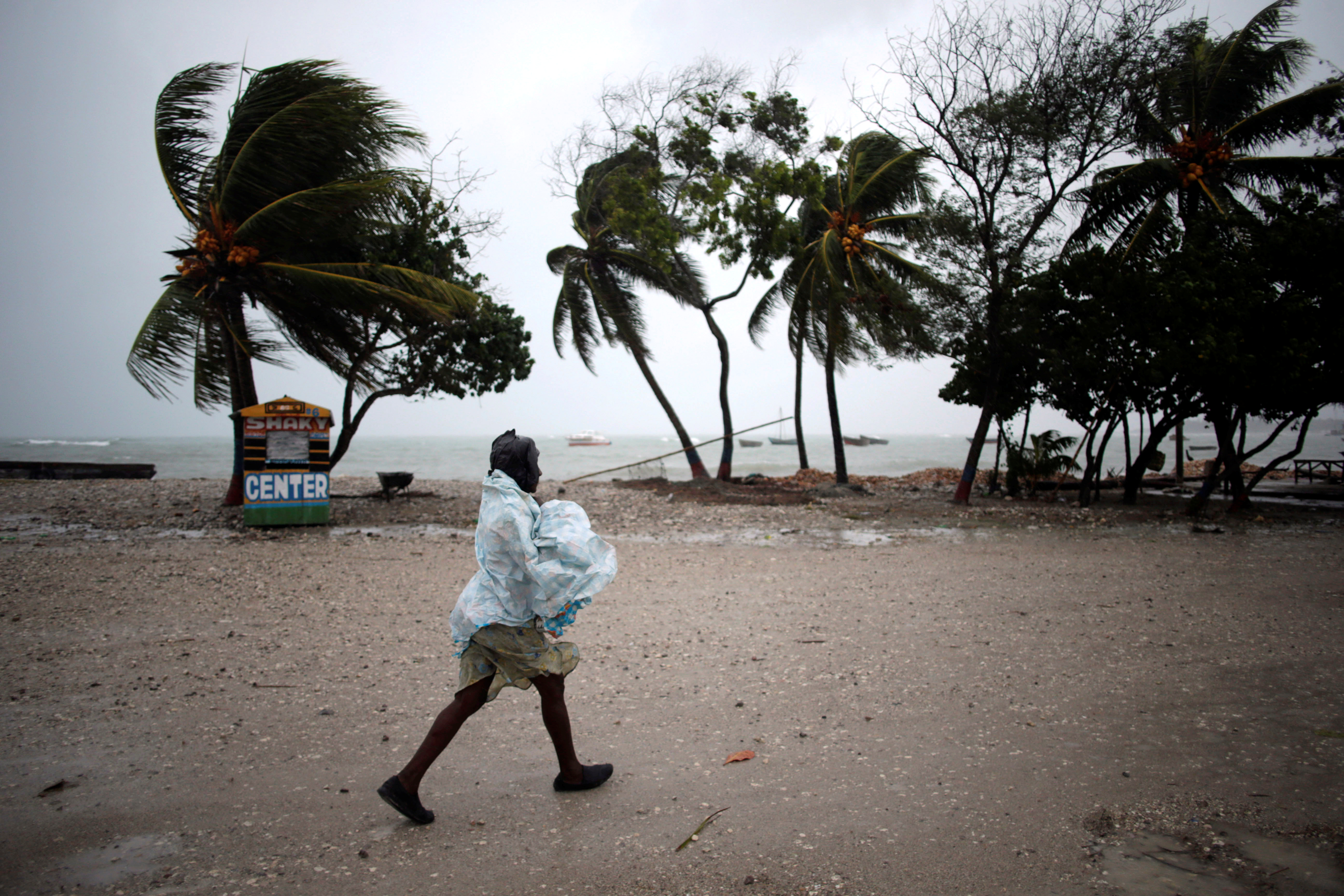
The outer bands of the cyclone already had reached the area late on Monday, flooding dozens of houses in Les Anglais when the ocean rose, the mayor said. In the town of Les Cayes on the southern coast, the wind bent trees and the power went out.

A woman protects herself from rain as Hurricane Matthew approaches in Les Cayes, Haiti. REUTERS/Andres Martinez Casares

A woman protects herself from rain as Hurricane Matthew approaches in Les Cayes, Haiti. REUTERS/Andres Martinez Casares


CHILDREN, PRISONERS MOVED

“We have gusts of wind hitting the whole area and the people have fled to a shelter,” Les Anglais mayor Jean-Claude Despierre said.

In the nearby town of Tiburon, the mayor said people who had been reluctant to leave their homes also ran for cover when the sea rose.

“Everyone is trying to find a safe place to protect themselves, the situation is very difficult,” Mayor Remiza Denize said, describing large waves hitting the town.

Poor Haitians are often reluctant to leave home in the face of storms, fearing their few belongings will be stolen.

Civil protection authorities said 130 children were evacuated by bus to a high school in the capital from an orphanage in the shoreside Cite Soleil slum, made up of tin shacks and open sewers and known as Haiti’s largest shanty town.

On the northern coast, about 300 detainees were transferred from a prison near the sea in the town of Jeremie, the Interior Ministry said.

The cyclone comes at a bad time for Haiti, where tens of thousands of people still live in tents after a 2010 earthquake that killed upwards of 200,000 people.

Cholera introduced by U.N. peacekeepers is expected to rise in the October rainy season, and the country was due to hold a long-delayed presidential election on Oct. 9.

The office of Interim President Jocelerme Privert said there was no change to the election date.

Crawling north at about 9 miles-per-hour (15 kph), the strongest storm since Hurricane Felix in 2009 threatens to linger long enough for its winds and rain to cause great damage in Haiti, where it will spend much of the day before hitting Cuba and the Bahamas later on Tuesday.

It will possibly reach Florida by Thursday as a major hurricane, although weaker than at present, the hurricane center said. Governor Rick Scott declared a state of emergency for Florida on Monday, designating resources for evacuations and shelters and putting the National Guard on standby.

CUBA PREPARES

In Les Cayes about 150 people huddled without electricity or food in the town’s largest shelter, a school.

“Since yesterday we’ve had nothing … We must sleep on the floor … Everyone is hungry,” said Erick Cange, 69 years old, a resident of the La Savanne neighborhood surrounding the school.

The conditions in the shelter compared unfavorably with Haiti’s neighbor Cuba, where authorities spent days organizing teams of volunteers to move residents to safety and secure property.

The storm is expected to make a direct hit later on Tuesday in the province of Guantanamo, the disputed home to a U.S. Naval base and military prison but also a small Cuban city. The U.S. Navy ordered the evacuation of 700 spouses and children of service personnel as the storm approached.

Guantanamo’s mountainous terrain is the country’s second coffee producer after nearby Santiago, and the storm poses a major threat to the current harvest.

The U.S. Agency for International Development said on Monday it was providing a combined $400,000 in aid to Haiti and Jamaica. The agency said in a statement it had pre-positioned relief supplies and was preparing to ship in additional supplies to the central Caribbean.

(Reporting by Joseph Guyler Delva in Port-au-Prince and Maini Brice in Les Cayes; Additional reporting by Sarah Marsh in Cuba and Brendan O’Brien in Milwaukee; Writing by Frank Jack Daniel; Editing by Simon Gardner and Bill Trott)

Hurricane Matthew’s threat to Haiti grows, some resist shelters

Families aboard a plane to evacuate them

By Makini Brice and Joseph Guyler Delva

LES CAYES/PORT-AU-PRINCE (Reuters) – Hurricane Matthew edged closer to Haiti on Monday, bringing 130- mile-per-hour (215 kph) winds and torrential rain that could wreak havoc in the Caribbean nation, although some 2,000 people in one coastal town refused to evacuate.

Matthew’s center is expected to near southwestern Haiti and Jamaica on Monday night, the U.S. National Hurricane Center said.

Crawling towards Haiti’s Les Cayes, Jamaica and Cuba at five miles per hour (seven kph), the storm could be just as slow leaving, giving its winds and rain more time to cause damage.

“We are worried about the slow pace of Hurricane Matthew, which will expose Haiti to much more rain, and the country is particularly vulnerable to flooding,” said Ronald Semelfort, director of Haiti’s national meteorology center.

The storm comes at a bad time for Haiti. The poorest country in the Americas is set to hold a long-delayed election next Sunday.

A combination of weak government and precarious living conditions make the country particularly vulnerable to natural disasters. More than 200,000 people were killed when a magnitude 7 earthquake struck in 2010.

“Even in normal times, when we have rain we have flooding that sometimes kills people,” said Semelfort, comparing Matthew to 1963’s Hurricane Flora, which swept away entire villages and killed thousands in Haiti.

RESISTANCE

In Jamaica too, officials were scrambling to protect the vulnerable, as residents boarded up windows and flocked to supermarkets to stock up on food, water, flashlights and beer.

In Cuba, which Matthew is due to reach on Tuesday, evacuation operations were well underway, with people voluntarily moving their belongings into neighbors’ houses or heading to shelters. Some even found cliff-side caves they said were the safest places to ride out storms.

Matthew was about 245 miles (3955 km) south-southeast of Jamaica’s Kingston early on Monday and moving north toward Haiti. The hurricane center ranked it at Category 4 on the five-step Saffir-Simpson scale of hurricane intensity.

In Haiti, some streets were already flooded in Les Cayes, a town of about 70,000 people that was previously ravaged by hurricanes in 1781 and 1788.

But Haitian officials said about 2,000 residents of the La Savane neighborhood of Les Cayes refused to heed government calls to move out of their seaside homes, even though they were just a few miles from where the center of the hurricane is forecast to make landfall.

As the wind died down at night, people remained outside in La Savane, hanging out on porches, playing checkers and dominoes outside, and listening to music.

“The police and local authorities and our evacuation teams have been instructed to do all they can to move those people,” Interior Minister Francois Anick Joseph said.

“They have also been instructed to move them by force if necessary. We have an obligation to protect those peoples lives, even against their will.”

However, the chief of police for the southern region, Luc Pierre, said it was almost impossible to force such a large number of people to leave their homes.

“I would have to arrest all those people and take them to a safe place. This is very difficult,” he said, adding that the power had already gone off in the town.

Poor Haitians are at times reluctant to leave their homes in the face of impending storms, fearing their belongings will be stolen after they leave.

Only a few families had opted to move to a high school in La Savane, designated as a shelter for up to 600 people. It was without electricity and lit only by candlelight.

“There are babies crying here; there is nothing at all,” said Nadja, 32, who was pregnant with her fourth child.

(Additional reporting by Sarah Marsh and Gabriel Stargardter; Writing by Frank Jack Daniel; Editing by Simon Cameron-Moore, Larry King)