California wildfire that killed at least 85 people fully contained

FILE PHOTO: Vanthy Bizzle hands some small religious figurines to her husband Brett Bizzle in the remains of their home after returning for the first time since the Camp Fire forced them to evacuate in Paradise, California, U.S. November 22, 2018. REUTERS/Elijah Nouvelage/File Photo

(Reuters) – The deadliest wildfire in California history that destroyed the mountain town of Paradise and killed at least 85 people was 100 percent contained on Sunday, according to state fire officials.

FILE PHOTO: The word "sorry" is spray painted on the edge of a property burned by the Camp Fire in Paradise, California, U.S. November 21, 2018. REUTERS/Elijah Nouvelage

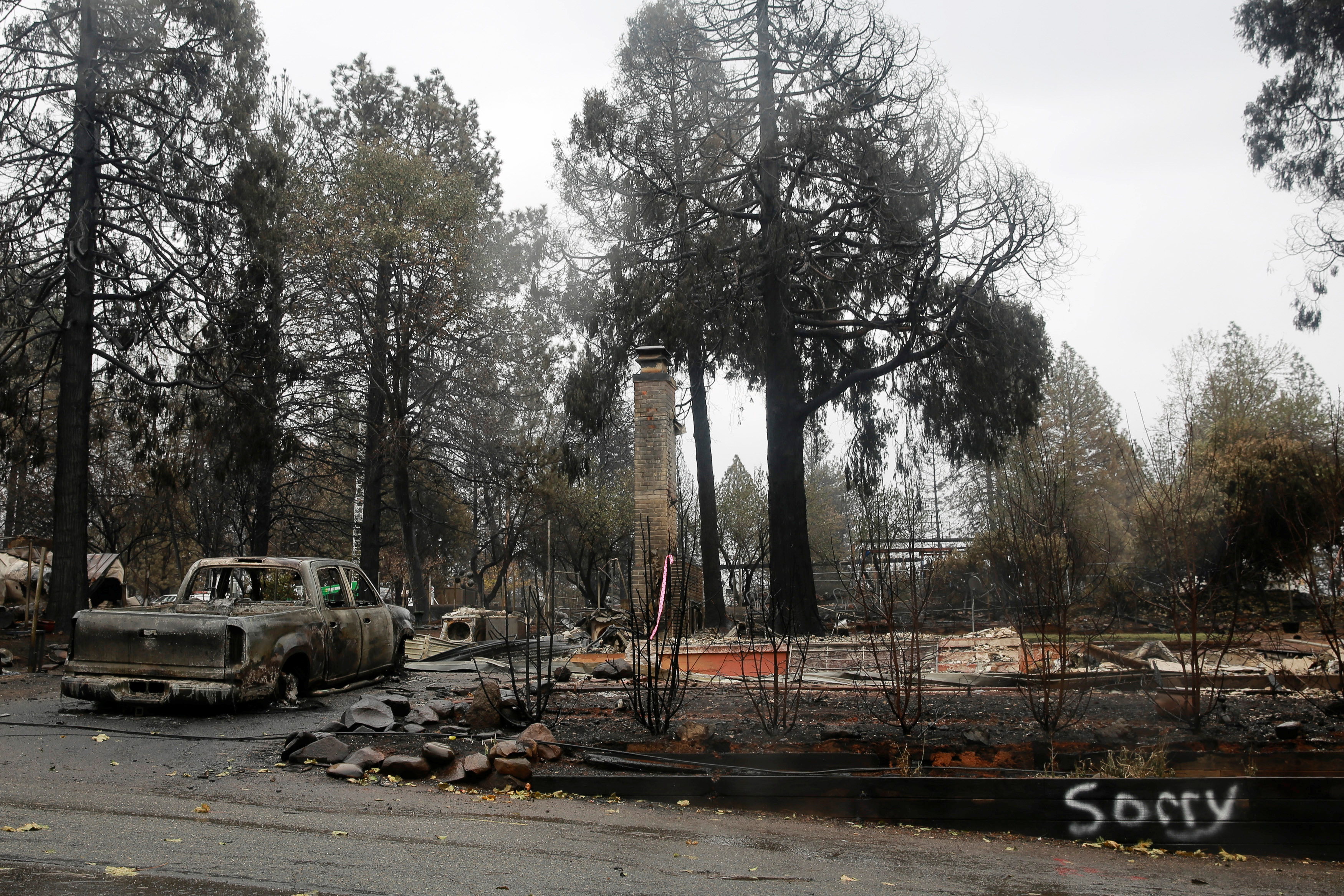
FILE PHOTO: The word “sorry” is spray painted on the edge of a property burned by the Camp Fire in Paradise, California, U.S. November 21, 2018. REUTERS/Elijah Nouvelage

The number of people still missing from the Camp Fire north of San Francisco dropped to 249 on Sunday, the Butte County Sheriff’s Office said. The number was revised down from 475 as people who were believed missing were found in shelters, staying in hotels or with friends, officials said, adding that many did not know they were on the list.

The Camp Fire that started on Nov. 8 destroyed nearly 14,000 homes and burned nearly 154,000 acres (62,000 hectares) – an area five times the size of San Francisco.

Searchers will have a few more days of dry weather, but starting late Tuesday, another 2-5 inches (5 to 13 cm) of rain is expected to drop on the Sierra Nevada foothills through next Sunday, hampering the searchers work and renewing fears of flash floods and mudslides, forecasters said.

“The fear is that the rain will drop in intense bursts,” Brian Hurley, a meteorologist with the federal Weather Prediction Center in College Park, Maryland, said early Sunday.

“All the vegetation has burned away, and that’s a dangerous recipe for mudslides,” Hurley said.

Last week, 2-3 inches (5-8 cm) of rain fell there and turned ash from the thousands of destroyed homes into slurry, complicating the work of finding bodies reduced to bone fragments.

Butte County Sheriff Kory Honea has warned that remains of some victims may never be found.

The town of Paradise was a popular destination for retirees, with people aged 65 or older accounting for a quarter of its 27,000 residents. Most of the victims of the fire identified so far were of retirement age.

Investigators have yet to determine the cause of the fire.

Thousands of people forced to flee Paradise spent Thanksgiving in warehouses in the nearby city of Chico, or with friends or relatives in nearby towns.

(Reporting by Rich McKay in Atlanta; additional reporting by Andrew Hay in New Mexico, Alex Dobuzinskis in Los Angeles and Gabriella Borter and Gina Cherelus in New York; Editing by Lisa Shumaker)

Tropical Storm Rosa will still pack a punch to southern California, Arizona

Hurricane Rosa is shown from a National Oceanic and Atmospheric (NOAA) GOES East satelite over the eastern Pacific Ocean on September 27, 2018, in this image provided September 28, 2018. Image taken September 27, 2018. NOAA/Handout via REUTERS

(Reuters) – Tropical Storm Rosa diminished from a Pacific hurricane over the weekend, but will still bring strong winds and dangerous rip currents to Southern California on Monday, the National Hurricane Center (NHC) said.

It could also bring life-threatening flash floods to central Arizona over the next few days, the NHC added.

“This storm still has a punch, it’s still dangerous,” said David Roth, a meteorologist with the National Weather Service’s Weather Prediction Center in College Park, Maryland.

Swells generated by Rosa on Monday are affecting the coasts of southwestern Mexico, the west coast of the Baja California peninsula and southern California through Tuesday, the weather service said in an advisory.

“We’re already getting rains in southern California through southwest Arizona,” Roth said.

Baja California and southern California could receive 3 to 6 inches of rain, with isolated spots of 10 inches in the next few days. The desert southwest of Arizona could get up to 4 inches of rain, potentially bringing flash floods and mud slides, Roth said.

Rosa was packing 50 mph (85 kmh) winds and was about 140 miles (225 km) west southwest of Punta Eugenia, Mexico at 2 a.m. Monday, Pacific time, the NHC said.

It is expected to diminish in strength as it makes landfall on Monday night and its remnants are expected to move across the southwestern desert on Tuesday.

(Reporting by Rich McKay; Editing by Gaerth Jones)

Hawaii residents hit by floods from Hurricane Lane as new storm forms

FILE PHOTO: Large waves crash against the shoreline on the east side of Oahu as Hurricane Lane approaches Honolulu, Hawaii, U.S. August 24, 2018. REUTERS/Hugh Gentry

By Dan Whitcomb

(Reuters) – Flash flood warnings were issued on Tuesday for the Hawaiian island of Kauai, with residents on the north coast told to evacuate and others left stranded by high water as the remnants of Hurricane Lane drenched the archipelago and a new storm brewed in the Pacific Ocean.

Hawaii was spared a direct hit from a major hurricane as Lane diminished to a tropical storm as it approached and then drifted west, further from land. But rain was still pounding the island chain, touching off flooding on Oahu and Kauai.

“It has been a steady rain since after Lane but I got up 2:30 a.m. (Hawaiian Standard Time) to the National Weather Service flash flood advisory and that’s when we put out the release as well as an island-wide telephone call,” County of Kauai spokesman Alden Alayvilla said.

The advisory urged residents near Hanalei Bridge on the north side of the island to evacuate their homes due to rising stream levels. A convoy that had been used to escort residents over roads damaged by historic floods in April between was shut down, leaving many cut off.

“Heavy pounding and hazardous conditions are being reported island-wide. Motorists are advised to drive with extreme caution. Updates will be given as more information is made available,” the Kauai Emergency Management Agency said.

A flash flood watch also remained in effect for Oahu, home to the state capital Honolulu and 70 percent of Hawaii’s 1.4 million residents.

Micco Godinez, who lives on the north side of Kauai, said he found the only road out of Hanalei, where he lives, barricaded by police vehicles when he tried to leave for work on Tuesday morning. He expected to be stranded for at least another day.

“I can’t get out at all,” Godinez said. “Our little community of Hanalei is isolated and then west of us is even more isolated,” he said.

Even as Hawaii residents sought to recover from Lane, they kept a watchful eye on Tropical Storm Miriam, spinning in the Pacific Ocean some 2,000 miles to the east and expected to become a hurricane by the time it approaches the islands.

“Miriam is supposed to go north and dissipate in the colder waters and drier air, so I’m not really worried about it,” Godinez said. “But it is hurricane season, and there’s another one behind that. You know what they say: Without rain you wouldn’t have rainbows.”

(Reporting by Dan Whitcomb; Editing by Lisa Shumaker)

Hurricane Lane threatens direct hit on Hawaii, churns toward Oahu

A photo taken from the International Space Station and moved on social media by astronaut Ricky Arnold shows Hurricane Lane in the early morning hours near Hawaii, U.S., August 22, 2018. Courtesy @astro_ricky/NASA/Handout via REUTERS

y Jolyn Rosa

HONOLULU (Reuters) – Hurricane Lane, threatening a direct hit as Hawaii’s worst storm in a quarter century, on Thursday churned toward Oahu, the island with the largest population, as schools, government offices, and business closed and residents stocked up on supplies.

Packing sustained winds of up to 130 miles per hour (215 km per hour), Lane could dump 10 to 20 inches (25-50 cm) of rain, triggering flash floods and landslides, the National Weather Service (NWS) said. More than 30 inches could fall in some places, it said.

“Preparations to protect life and property should be rushed to completion,” the NWS Central Pacific Hurricane Center in Honolulu said in an advisory.

As of early Thursday, Lane was centered about 210 miles (335 km) south-southwest of Kailua-Kona, a town on the west coast of the Big Island, the NWS said. It was classified as a powerful Category 4 storm on the five-step Saffir-Simpson scale of hurricane strength.

The NWS said the storm weakened slightly overnight but excessive rainfall would affect the Hawaiian islands into the weekend, “leading to significant and life-threatening flash flooding and landslides.”

More than a foot of rain has already fallen on part of the Big Island, the NWS said on Thursday morning.

The center also warned of “very large and damaging surf” along exposed west- and south-facing shorelines, likely leading to significant coastal erosion.

A hurricane warning was in effect for Oahu, Maui County, and Hawaii County. The islands of Kauai and Niihau remained on hurricane watch and could face similar conditions starting Friday morning.

Governor David Ige has urged residents to take the threat seriously and prepare for the worst by setting aside a 14-day supply of water, food, and medicines.

All public schools, University of Hawaii campuses and nonessential government offices on the islands of Oahu and Kauai will be closed for at least two days starting on Thursday, Ige said Wednesday.

The shelves of a downtown Honolulu Walmart were stripped of items ranging from canned tuna to dog food as well as bottled water and coolers full of ice after warnings of possible power outages.

“I went to Safeway last night for regular groceries. Everyone was in a panic,” said Thao Nguyen, 35, an employee at a Honolulu branch of Hawaiian shirt retailer Roberta Oaks.

Long lines of cars formed at gasoline stations in Honolulu and people pulled small boats from the water ahead of the expected storm surge. U.S. Navy ships and submarines based in Hawaii were instructed to leave port, a common practice when a hurricane approaches to avoid damage.

President Donald Trump declared a state of emergency for Hawaii and ordered federal authorities to help supplement state and local responses, the White House said on Thursday.

The most powerful hurricane on record to hit Hawaii was Category 4 Iniki, which made landfall on Kauai island on Sept. 11, 1992, according to the National Oceanic and Atmospheric Administration. It killed six people and damaged or destroyed more than 14,000 homes.

(Additional reporting by Gina Cherelus in New York, Brendan O’Brien in Milwaukee, Doina Chiacu in Washington, and Steve Gorman and Dan Whitcomb in Los Angeles; Editing by Jeffrey Benkoe and Marguerita Choy)

Flash floods kill at least 10 in downpour near Athens

Flash floods kill at least 10 in downpour near Athens

By Vassilis Triandafyllou and Alkis Konstantinidis

MANDRA, Greece (Reuters) – At least 10 people died in flash floods in Greece on Wednesday in the most deadly such incident in recent years when a torrent of red mud swept through towns west of the capital Athens after heavy rain, authorities said.

Torrential rain of this type is uncommon in Greece, where poor infrastructure can leave citizens vulnerable to flooding.

The overnight deluge turned roads in the industrial towns of Nea Peramos and Mandra, about 27 km (17 miles) west of Athens, into fast-flowing rivers and trapped dozens of people in their homes or cars.

Some residents were forced onto rooftops and balconies while cars were thrust onto porches or tipped onto their side. Twelve people were rescued from a bus on a bridge.

“This is a biblical disaster,” Mandra Mayor Yianna Krikouki told state broadcaster ERT. “Everything is gone.”

Heavy vehicles, a bus and cars were stranded under more than a meter of water on a nearby motorway. The force of the water smashed through walls and broke through roads.

In Mandra, five people – two women and three men – were found dead either in their flooded homes or in allotments. Another two were found floating in the sea.

“The walls collapsed, the cars were carried away and they broke everything here. There is nothing left,” resident Marina Kolia said. “Water is everywhere in the house.”

The wall of a local cemetery crumbled and vehicles collided with tree trunks. The fire brigade said at least three people were missing, and an unspecified number of people injured.

Prime Minister Alexis Tsipras expressed regret at the loss of life and called for an emergency meeting with ministers.

Greece has had around a week of heavy rain. A state of emergency was declared in the west Attica region, which includes Nea Peramos and Mandra, on Wednesday.

Both towns, which have a combined population of about 20,000 people, lie in the foothills of a mountain in western Attica. Many Greek housing settlements are built without taking into account town planning regulations.

An Athens prosecutor ordered an urgent preliminary investigation into the deaths and destruction caused and was also investigating possible urban planning offences.

On Tuesday, Greece declared a state of emergency on the eastern island of Symi, just off the coast of Turkey, after a storm swept cars into the sea, damaged homes and cut off electricity and water supplies.

(Additional reporting by Karolina Tagaris and Renee Maltezou Editing by Matthew Mpoke Bigg)

Storms disrupt Beijing flights, authorities warn of flash floods, landslides

Tourists hold umbrellas as they visit Tiananmen Square during a rainstorm in Beijing, China August 12, 2017. REUTERS/Stringer

By Josephine Mason and Shu Zhang

BEIJING (Reuters) – Thunderstorms lashed Beijing on Saturday, disrupting hundreds of flights at one of the world’s largest airports, while authorities warned that rain and wind could cause landslides in the area where a 7.0-magnitude earthquake struck this week.

Beijing authorities raised their weather alert level to “orange” from “yellow” early in the afternoon, warning against lightning, hail, wind and as much as 70 mm (3 inches) of rain, threatening flash floods in mountainous areas.

By early afternoon rain subsided in some parts of the capital, but nine roads were still flooded and 171 tourist sites were shut, the official news agency Xinhua said.

At China’s busiest airport, almost 500 flights were listed as canceled from 9 a.m. until midnight and 182 were delayed, the website of Beijing Capital International Airport Co Ltd showed, urging travelers to check for flight updates.

Air China Ltd said on its Weibo social media account that about 137 of its flights in and out of the capital had been canceled by 11 a.m. (0300 GMT).

Torrential rainstorms are fairly frequent in Beijing in the summer months, often causing long delays at the airport.

One user of China’s Twitter-like Weibo said she had been stuck at the airport for eight hours waiting for a flight home.

“There are no free seats, I’m having to sit on the floor, I’m jetlagged and I’m really tired,” said the user, who goes by the handle ‘Vivian not soymilk’.

Other airports affected by the downpours included Shanghai, Nanjing in Jiangsu province, Hangzhou in Zhejiang along the Yangtze River delta.

The others were in northern regions: Shijiazhuang in Hebei, Taiyuan in Shanxi, Lanzhou in Gansu, Xining in Qinghai and Yinchuan in Ningxia.

In a statement, China’s National Meteorological Centre cautioned rescue crews working in Jiuzhaigou, in the southwestern province of Sichuan, to be on alert for landslides and lightning.

Heavy rain was expected across south-eastern China on Saturday, it said.

Widespread flooding hit two towns, Xiangbei and Xiangxi in the southern province of Hunan, Xinhua said. Rainfall across the province ranged from 100 mm (4 inches) to 200 mm (8 inches).

The extreme weather followed a tornado that struck Inner Mongolia on Friday, killing five people, injuring more than 50 and destroying homes in a major city.

(Reporting by Josephine Mason and Shu Zhang; Editing by Eric Meijer)

Bangladesh raises highest danger warning as cyclone takes aim

A Sri Lankan Navy rescue team member carries an old man on a flooded road during a rescue mission in Nagoda village in Kalutara, Sri Lanka May

By Ruma Paul and Dinuka Liyanawatte

DHAKA/AGALAWATTE, Sri Lanka/ (Reuters) – Bangladesh raised its storm danger signal to the highest level of 10 on Monday as a severe and intensifying cyclone churned toward its low-lying coast and was expected to make landfall in the early hours of Tuesday.

Impoverished Bangladesh, hit by cyclones every year, warned that some coastal areas were “likely to be inundated by a storm surge of four to five feet (1.2 to 1.5 meters)” above normal because of approaching Cyclone Mora.

The Disaster Ministry ordered authorities to evacuate people from the coast, the ministry’s additional secretary, Golam Mostafa, told reporters in Dhaka. About 10 million of Bangladesh’s population of 160 million live in coastal areas.

River ferries had suspended operations and fishing boats called in to safety.

“Maritime ports of Chittagong and Cox’s Bazar have been advised to lower danger signal number seven but instead hoist great danger signal number ten (repeat) ten,” a government weather bulletin said.

“The coastal districts of Chittagong, Cox’s Bazar, Noakhali, Laxmipur, Feni, Chandpur and their offshore islands … will come under danger signal number ten (repeat) ten.”

Bangladesh is hit by storms, many of them devastating, every year. Half a million people had their lives disrupted in coastal areas such as Barisal and Chittagong in May last year.

It is still recovering from flash floods that hit the northeast, affecting millions of people, in April. Rice prices have reached record highs and state reserves are at 10-year lows in the wake of flooding that wiped out around 700,000 tonnes of rice.

The cyclone formed after monsoon rains triggered floods and landslides in neighboring Sri Lanka, off India’s southern tip, which have killed at least 177 people in recent days, authorities said, with 24 killed in storms in the eastern Indian state of Bihar, either by lightning strikes or under collapsed village huts.

India warned of heavy rain in the northeastern states of Tripura, Mizoram, Manipur, Nagaland and Arunachal Pradesh as Mora moved further up the Bay of Bengal.

RUBBER AND TEA PLANTATIONS HIT

Floods reached roof level and cut off access to many rural Sri Lankan villages, disrupting life for 557,500 people, many of them workers on rubber plantations, officials said. Nearly 75,000 people had been forced out of their homes.

Villagers in Agalawatte, in a key rubber-growing area 74 km (46 miles) southeast of the capital, Colombo, said they were losing hope of water levels falling soon after the heaviest rain since 2003. Fifty-three villagers died and 58 were missing.

“All access to our village is cut off. A landslide took place inside the village and several houses are buried,” Mohomed Abdulla, 46, told Reuters.

Some areas in the southern coastal district of Galle, popular with foreign tourists, have not received relief due to lack of access.

“My entire village is cut off and nobody can come to this village,” C.M. Chandrapla, 54, told Reuters by phone from the tourist village of Neluwa.

“There have been no supplies for the past two days. Water has gone above three-storey buildings and people survive by running to higher ground.”

A boy rides his bike along a flooded road in Nagoda village, in Kalutara, Sri Lanka May 29, 2017.

A boy rides his bike along a flooded road in Nagoda village, in Kalutara, Sri Lanka May 29, 2017. REUTERS/Dinuka Liyanawatte

The Sri Lankan military has sent in helicopters and boats in rescue efforts in the most widespread disaster since the 2004 Boxing Day tsunami. About 100 people were missing in total.

The meteorology department forecast torrential rains over the next 36 hours.

Residents in seven densely populated districts in the south and center of Sri Lanka were asked to move away from unstable slopes in case of further landslides.

The wettest time of the year in Sri Lanka’s south is usually during the southern monsoon, from May to September. The island also receives heavy rains in the North West monsoonal season from November to February.

Reuters witnessed some people stranded on the upper floors of their homes. Civilians and relief officials in boats  distributed food, water and other relief items.

One of the worst-hit areas was the southern coastal district of Matara which is home to black tea plantations. Rohan Pethiyagod, head of the Tea Board in the world’s largest exporter of top quality teas, said supplies would be disrupted for the next auction due to a lack of transportation.

Sri Lanka has already appealed for international assistance from the United Nations and neighboring countries.

(Additional reporting by Ranga Sirilal in Colombo; Writing by Shihar Aneez and Sanjeev Miglani; Editing by Nick Macfie)

Powerful storms head for U.S. West after thousands flee floods

Partially submerged building in California

(Reuters) – Powerful storms packing heavy rain and snow will lash the U.S. West on Tuesday, a day after thousands of people fled their homes to escape floods, forecasters said.

A band of heavy downpours will drench northern California and heavy snow will fall in the Sierra Nevada mountains into Wednesday, exacerbating the threat of flooding, the National Weather Service said.

The storms are part of weather system called the “Pineapple Express” that has soaked a vast area from Hawaii to the typically drought-prone states of California and Nevada.

Just north of San Francisco, the Russian River in Sonoma County flooded early on Monday, forcing the evacuation of more than 3,000 residents, officials said.

In Nevada, residents of about 400 homes in Reno were ordered to leave as rains swelled the Truckee River, which flows through the city, a county official said.

A woman died after she was struck by a falling tree in the San Francisco area, local officials and media reported.

Over the weekend, an ancient giant sequoia tree with a hollowed-out tunnel was toppled by floods in Calaveras Big Trees State Park just southeast of Sacramento.

California’s Napa Valley vinyards largely escaped undamaged and the rain was expected to replenish water supplies after five years of drought, said Patsy McGaughy, Napa Valley Vintners spokeswoman.

California officially remains in a state of drought as water is still scarce in the south.

But northern California’s Lake Oroville, the principal reservoir for the State Water Project, has 2.25 million acre feet of water, more than double the amount it had a year ago, Michael Anderson, state climatologist for the California Department of Water Resources, said.

(Reporting by Brendan O’Brien in Milwaukee)