Storm Michael expected to hit Florida as a hurricane midweek

A satellite image of Tropical Storm Michael taken Monday. NOAA/via REUTERS

By Rich McKay and Jon Herskovitz

(Reuters) – Tropical Storm Michael is on track to hit the Florida Panhandle midweek as a Category 2 hurricane packing 100 miles per hour (160 kmh) or stronger winds, the U.S. National Hurricane Center (NHC) said early Monday in an advisory.

The tropical storm is expected to swell into a Category 1 hurricane as soon as Monday night or early Tuesday as it rolls into the U.S. Gulf of Mexico, with winds of 70 mph, as of 5 a.m. eastern time, forecasters said, just shy of being named a hurricane.

A storm is designated a Category 1 hurricane if it reaches speeds of 74 mph (119 km) or more, and a Category 2 hurricane at 96 mph (154 km) or more on the Saffir-Simpson hurricane wind scale.

Florida Gov. Rick Scott declared a state of emergency in more than 20 counties along the Florida Panhandle and Big Bend on Sunday and has put more than 5,000 National Guard soldiers on alert.

“Our state understands how serious tropical weather is and how devastating any hurricane of tropical storm can be,” Scott said in a statement.

He advised Gulf Coast residents to prepare for possible evacuation orders.

Michael battered parts of Mexico and Cuba with powerful winds and drenching rains on Sunday and into early Monday as it churned in the Caribbean.

The storm moved north on a path between Cozumel in southeastern Mexico and the western tip of Cuba, the Miami-based hurricane center said.

A hurricane watch has been issued from the Alabama-Florida border eastward to the Suwanee River, Florida.

Outer bands from Michael are expected produce as much as 4 inches (10 cm) of rain through Tuesday in the Florida Keys, one of several areas in the state devastated by Hurricane Irma last year.

After hitting Florida, the storm is then forecast to move northeast along the Atlantic Coast and batter the Carolinas, which are still recovering from Hurricane Florence last month. That hurricane killed at least 50 people and caused billions of dollars in damage.

The Commodity Weather Group said on Sunday some oil rigs in the gulf area may be evacuated as a precaution, which may slow down operations but was not likely cause much interruption.

The Gulf of Mexico is home to 17 percent of U.S. crude oil and 5 percent of natural gas output daily, according to the U.S. Energy Information Administration.

More than 45 percent of the nation’s refining capacity is located along the U.S. Gulf Coast, which also is home to 51 percent of total U.S. natural gas processing capability.

(Reporting by Rich McKay in Atlanta and Jon Herskovitz in Austin, Texas; Editing by Raissa Kasolowsky)

Hurricane Lane lashes Hawaii with heavy rain, winds

A chicken hops through floodwaters in Hilo, Hawaii, U.S. August 23, 2018, in this still image from video obtained from social media. Kehau Comilla/via REUTERS

By Jolyn Rosa

HONOLULU (Reuters) – Hurricane Lane, a powerful Category 3 storm, lashed Hawaii on Thursday with high winds and torrential rain, causing flash floods, landslides and raging surf as residents hunkered down to ride out the storm.

The storm spun in the Pacific Ocean about 165 miles (260 km) southwest of Kailua-Kona and nearly 20 inches (51 cm) of rain had fallen on the eastern side of the Big Island of Hawaii, the National Weather Service (NWS) said.

“There’s lots and lots of rain, torrential rain, with a lot of moisture in the atmosphere,” NWS meteorologist Chevy Chevalier said, noting there were reports of 50 miles per hour (80 km/h) wind gusts. “We’re in it now.”

There were no reports of injuries, but roads were closed because of flash floods and landslides in the Pacific island state. Tourists were advised to stay away from a popular attraction on the island of Maui called the Seven Sacred Pools, a scenic cluster of waterfalls and grottos.

“Life threatening flash floods. This is a very dangerous situation. Avoid unnecessary travel,” Governor David Ige said on Twitter.

Evacuations were underway on parts of Molokai and Maui islands while power outages were being reported on social media.

The latest predictions showed the eye of the storm twisting west of the Big Island on Friday morning before glancing past Maui and several other islands later in the day on its way to Oahu. But authorities warned the islands could still expect to be hit hard.

Lane shifted from heading northwest and was headed north at 6 miles per hour as the Category 3 storm on the five-step Saffir-Simpson scale was packing winds of 120 mph (195 kph), the service said in an evening advisory.

“We’re telling everybody to take the storm seriously, make your final preparations, and be prepared to ride out what is going to be a prolonged rain event,” said Andrew Pereira, communications director for the city and county of the state capital Honolulu.

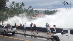
Incoming waves tower over bystanders in Kona, Hawaii, U.S. August 23, 2018 in this still image from video obtained from social media. Ryan Leinback/via REUTER

Incoming waves tower over bystanders in Kona, Hawaii, U.S. August 23, 2018, in this still image from video obtained from social media. Ryan Leinback/via REUTERS

REMEMBERING INIKI

The National Hurricane Center warned storm surges could raise water levels 3 to 5 feet (1 to 1.5 meters) above normal along the western shores of the Big Island and that extreme rainfall could mean “numerous evacuations and rescues.”

Ige has urged residents to set aside a 14-day supply of water, food, and medicine. All public schools, University of Hawaii campuses and non-essential government offices on the islands of Oahu and Kauai were closed at least through Friday.

“We are in our room at Alohilani Resort waiting for Hurricane Lane to arrive,” said Janina Ballali on Twitter. “Hopefully, the hurricane will have mercy with our beloved Oahu.”

Par Pacific Holdings Inc said it had shut its 93,500 barrel-per-day refinery in Kapolei due to the storm.

In Hanalei on Kauai, rain fell Thursday as residents and businesses prepared for the hurricane while tourists continued to shop and dine in places that were still open.

Dave Stewart, owner of Kayak Hanalei, had boarded up the windows on his shop by mid-afternoon and moved the company’s rental kayaks to high ground.

He said he wasn’t taking any chances, having lived through severe flooding on Kauai’s North Shore in April and through Hurricane Iniki in 1992.

“That was total destruction,” he said of Iniki. “Seven out of 10 telephone poles were down, so even if your house was OK, you couldn’t get out.”

Iniki was the most powerful hurricane on record to hit Hawaii, making landfall on Kauai island on Sept. 11, 1992, as a Category 4. It killed six people and damaged or destroyed more than 14,000 homes.

The shelves of a downtown Honolulu Walmart were stripped of items ranging from canned tuna to dog food, bottled water and coolers full of ice.

Video footage showed whipping palm trees and darkening skies in Maui. In the Manoa Valley neighborhood in Honolulu, sidewalks typically full of joggers and dog walkers were empty as residents stood outside their homes watching the skies and businesses closed early for the day.

President Donald Trump declared a state of emergency for Hawaii and ordered federal authorities to help supplement state and local responses, the White House said on Thursday.

The Coast Guard has ordered all harbors to close to incoming vessels and the U.S. Navy moved most of its fleet out of Pearl Harbor, where ships could provide aid after the storm.

Since Hurricane Maria devastated Puerto Rico last year, the Federal Emergency Management Agency has made changes to how it works, FEMA Administrator Brock Long said at a briefing in Washington, making sure generators are in place so they can provide power to residents and quickly restart the water system.

“It’s not just providing food and water. If you fix the power first, you solve 90 percent of the problems,” he said.

(Reporting by Jolyn Rosa; Additional reporting by Gina Cherelus in New York, Brendan O’Brien in Milwaukee, Doina Chiacu and Lisa Lambert in Washington and Steve Gorman and Dan Whitcomb in Los Angeles; Writing by Dan Whitcomb; Editing by Janet Lawrence and Raissa Kasolowsky)

Thousands told to flee ‘out of control’ California wildfire

Smoke from the Cranston Fire is shown from east of Lake Hemet in Riverside County, California, U.S., July 26, 2018. USFS/Handout via REUTERS

By Dan Whitcomb

LOS ANGELES (Reuters) – An “out of control” California wildfire prompted officials on Thursday to order thousands of residents to flee their homes as firefighters struggled to contain the blaze in a mountainous area near the city of Redding.

The Carr Fire, about 150 miles (240 km) north of Sacramento, had blackened about 20,000 acres (8,100 hectares) early Thursday, three times its last-reported size a day ago. Crews contained just 10 percent of it, the California Department of Forestry and Fire Protection said.

The conflagration is one of about 75 major wildfires burning in the United States in an unusually active fire season that has already scorched about 3.98 million acres, mostly in western states.

That is above the 10-year average for the same period of 3.54 million acres, according to the National Interagency Fire Center.

The Carr Fire is currently in a sparsely inhabited area, but Cal Fire spokesman Scott McLean warned in a phone interview that it was heading toward Redding, a city of about 90,000 people.

“If you live in West Redding start packing and be prepared!” the California Highway Patrol said on Twitter. “This fire is out of control!”

The western fires were being supercharged by extreme temperatures above 100 degrees Fahrenheit (37 Celsius), erratic winds and low humidity, factors that were expected to remain on Thursday.

Further south, the Cranston Fire, believed to have been started by arson, had charred 4,700 acres around 90 miles east of Los Angeles in the San Jacinto Mountains. It was just 5 percent contained, Cal Fire officials said.

That blaze had forced 3,200 people to evacuate in resort communities including Idyllwild, Mountain Center and Lake Hemet as it destroyed five structures and threatened 2,100 homes, the agency said.

A suspect was arrested on Wednesday and accused of starting multiple fires including the Cranston Fire, fire officials said in a statement.

A third major blaze, the almost two-week-old, 43,300-acre Ferguson Fire, forced much of Yosemite National Park to close on Wednesday, as it poured thick smoke into the valley in the Sierra Nevada Mountains some 170 miles east of San Francisco.

A firefighter died and seven others have been hurt combating the blaze, which was 27 percent contained as of Thursday morning.

(Additional reporting by Brendan O’Brien in Milwaukee and Makini Brice in Washington; Editing by Scott Malone and Tom Brown)