Hurricane Lane lashes Hawaii with heavy rain, winds

A chicken hops through floodwaters in Hilo, Hawaii, U.S. August 23, 2018, in this still image from video obtained from social media. Kehau Comilla/via REUTERS

By Jolyn Rosa

HONOLULU (Reuters) – Hurricane Lane, a powerful Category 3 storm, lashed Hawaii on Thursday with high winds and torrential rain, causing flash floods, landslides and raging surf as residents hunkered down to ride out the storm.

The storm spun in the Pacific Ocean about 165 miles (260 km) southwest of Kailua-Kona and nearly 20 inches (51 cm) of rain had fallen on the eastern side of the Big Island of Hawaii, the National Weather Service (NWS) said.

“There’s lots and lots of rain, torrential rain, with a lot of moisture in the atmosphere,” NWS meteorologist Chevy Chevalier said, noting there were reports of 50 miles per hour (80 km/h) wind gusts. “We’re in it now.”

There were no reports of injuries, but roads were closed because of flash floods and landslides in the Pacific island state. Tourists were advised to stay away from a popular attraction on the island of Maui called the Seven Sacred Pools, a scenic cluster of waterfalls and grottos.

“Life threatening flash floods. This is a very dangerous situation. Avoid unnecessary travel,” Governor David Ige said on Twitter.

Evacuations were underway on parts of Molokai and Maui islands while power outages were being reported on social media.

The latest predictions showed the eye of the storm twisting west of the Big Island on Friday morning before glancing past Maui and several other islands later in the day on its way to Oahu. But authorities warned the islands could still expect to be hit hard.

Lane shifted from heading northwest and was headed north at 6 miles per hour as the Category 3 storm on the five-step Saffir-Simpson scale was packing winds of 120 mph (195 kph), the service said in an evening advisory.

“We’re telling everybody to take the storm seriously, make your final preparations, and be prepared to ride out what is going to be a prolonged rain event,” said Andrew Pereira, communications director for the city and county of the state capital Honolulu.

Incoming waves tower over bystanders in Kona, Hawaii, U.S. August 23, 2018 in this still image from video obtained from social media. Ryan Leinback/via REUTER

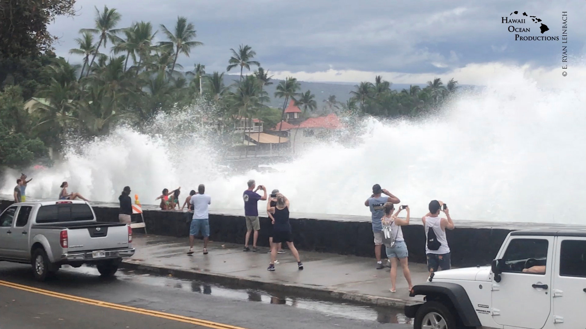
Incoming waves tower over bystanders in Kona, Hawaii, U.S. August 23, 2018, in this still image from video obtained from social media. Ryan Leinback/via REUTERS

REMEMBERING INIKI

The National Hurricane Center warned storm surges could raise water levels 3 to 5 feet (1 to 1.5 meters) above normal along the western shores of the Big Island and that extreme rainfall could mean “numerous evacuations and rescues.”

Ige has urged residents to set aside a 14-day supply of water, food, and medicine. All public schools, University of Hawaii campuses and non-essential government offices on the islands of Oahu and Kauai were closed at least through Friday.

“We are in our room at Alohilani Resort waiting for Hurricane Lane to arrive,” said Janina Ballali on Twitter. “Hopefully, the hurricane will have mercy with our beloved Oahu.”

Par Pacific Holdings Inc said it had shut its 93,500 barrel-per-day refinery in Kapolei due to the storm.

In Hanalei on Kauai, rain fell Thursday as residents and businesses prepared for the hurricane while tourists continued to shop and dine in places that were still open.

Dave Stewart, owner of Kayak Hanalei, had boarded up the windows on his shop by mid-afternoon and moved the company’s rental kayaks to high ground.

He said he wasn’t taking any chances, having lived through severe flooding on Kauai’s North Shore in April and through Hurricane Iniki in 1992.

“That was total destruction,” he said of Iniki. “Seven out of 10 telephone poles were down, so even if your house was OK, you couldn’t get out.”

Iniki was the most powerful hurricane on record to hit Hawaii, making landfall on Kauai island on Sept. 11, 1992, as a Category 4. It killed six people and damaged or destroyed more than 14,000 homes.

The shelves of a downtown Honolulu Walmart were stripped of items ranging from canned tuna to dog food, bottled water and coolers full of ice.

Video footage showed whipping palm trees and darkening skies in Maui. In the Manoa Valley neighborhood in Honolulu, sidewalks typically full of joggers and dog walkers were empty as residents stood outside their homes watching the skies and businesses closed early for the day.

President Donald Trump declared a state of emergency for Hawaii and ordered federal authorities to help supplement state and local responses, the White House said on Thursday.

The Coast Guard has ordered all harbors to close to incoming vessels and the U.S. Navy moved most of its fleet out of Pearl Harbor, where ships could provide aid after the storm.

Since Hurricane Maria devastated Puerto Rico last year, the Federal Emergency Management Agency has made changes to how it works, FEMA Administrator Brock Long said at a briefing in Washington, making sure generators are in place so they can provide power to residents and quickly restart the water system.

“It’s not just providing food and water. If you fix the power first, you solve 90 percent of the problems,” he said.

(Reporting by Jolyn Rosa; Additional reporting by Gina Cherelus in New York, Brendan O’Brien in Milwaukee, Doina Chiacu and Lisa Lambert in Washington and Steve Gorman and Dan Whitcomb in Los Angeles; Writing by Dan Whitcomb; Editing by Janet Lawrence and Raissa Kasolowsky)

‘Ash fallout’ alert after Hawaii volcano erupts in 30,000-foot plume

People watch as ash erupts from the Halemaumau crater near the community of Volcano during ongoing eruptions of the Kilauea Volcano in Hawaii, U.S., May 15, 2018. REUTERS/Terray Sylvester

By Terray Sylvester

PAHOA, Hawaii (Reuters) – An explosive eruption spewed ash 30,000 feet (9,144 meters) into the air above Hawaii’s Kilauea volcano on Thursday and residents of the Big Island were warned to take shelter as the plume engulfed a wide area, authorities said.

The wind could carry the ash plume as far as Hilo, the Big Island’s largest city and major tourism center, the County of Hawaii Civil Defense warned in an alert.

“Protect yourself from ash fallout,” it said.

The 4:15 a.m. (10:15 a.m. ET) blast that sent ash and smoke nearly six miles into the atmosphere was followed by other emissions of up to 12,000 feet, the U.S. Geological Survey said in a statement.

USGS geologists and staff were evacuated from the summit shortly before the blast and a webcam showed a gray plume of ash and chunks of magma known as pyroclasts that showered the volcano’s slopes.

An aviation red alert was issued due to risks that ash could be carried into aircraft routes and damage jet engines, USGS said.

The eruption could not only enshroud large areas of the Big Island in volcanic ash and smog but other Hawaiian Islands and potentially distant areas if the plume reaches up into the stratosphere and ash is carried by winds.

National Guard troops donned gas masks to protect themselves from toxic sulfur dioxide gas at the intersection of highways 130 and 132, the main exit routes from the village of Pahoa, 25 miles (40 km) east of the volcano, where many of the ground fissures have erupted, a Reuters reporter in the village said.

Schools were closed in the area due to “elevated sulfur dioxide (SO2) levels,” according to a phone alert from emergency authorities

The volcano has destroyed at least 37 homes and other structures in a small southeast area of the island where lava has oozed from fissures, forcing around 2,000 people to evacuate their homes.

Geologists had warned explosive eruptions could begin once Kilauea’s falling lava lake descended below the water table, allowing water to run on to the top of the lava column and create steam-driven blasts.

The powerful explosions could hurl “ballistic blocks” the size of refrigerators across a distance of more than half a mile (1 km) and shoot pebble-sized projectiles and debris up to a dozen miles, the USGS has warned.

Kilauea, one of the most active volcanoes in the world, last experienced explosive eruptions in 1924.

(Additional reporting by Jolyn Rosa in Honolulu; writing by Andrew Hay; Editing by Bill Tarrant)

Snow storm pounds U.S. Northeast, closing schools, snarling commutes

A man takes shelter as snow falls in Times Square in Manhattan in New York City, New York, U.S., March 7, 2018. REUTERS/Amr Alfiky

By Jonathan Allen

NEW YORK (Reuters) – The second winter storm in a week will continue to dump wet, heavy snow on New England on Thursday, forcing schools to close and leaving hundreds of thousands without power as it promised to slow the morning commute across the region.

A foot (30 cm) of snow and fierce wind gusts of up to 55 miles per hour (88 km/h) were expected from eastern New York through northern Maine on Thursday after the storm slammed the region on Wednesday, the National Weather Service said in several watches and warnings.

Up to 2 feet of snow accumulation was expected in some inland parts of New Jersey, New York, Connecticut and Massachusetts and 18 inches was possible in Maine.

Boston public schools along with dozens of schools throughout New England canceled classes on Thursday as local officials and forecasters warned commuters of whiteout conditions and slick roads.

“With snow removal efforts underway, motorists are asked to stay off roads, stay home and stay safe,” the Boston Police Department said on Twitter.

Amtrak suspended passenger train services between New York City and Boston until at least 10 a.m. local time and canceled dozens of routes on Thursday.

Two dozen flights were already canceled early on Thursday morning after about half of all scheduled flights were canceled at the three major airports serving New York City on Wednesday.

The website said more than 2,100 flights had been delayed and 2,700 canceled, most of them in the Northeast, as of 8 p.m. local time on Wednesday.

The dense snow and strong winds downed trees and power lines, knocking power out for hundreds of thousands in New England and the Mid Atlantic, according to Poweroutage.us, a website that tracks outages.

“4am, no power (no heat), waiting for a text from work to say “we will be closed today”. Fingers crossed!” tweeted Jessica Squeglia in Peabody, Massachusetts.

Connecticut Governor Dannel Malloy ordered many state workers to head home early on Wednesday afternoon at staggered intervals to avoid traffic snarls on slippery roads.

The governors of New Jersey and Pennsylvania declared states of emergency, giving them access to support from the U.S. government if needed.

Last week’s storm brought major coastal flooding to Massachusetts, killed at least nine people and knocked out power to about 2.4 million homes and businesses in the Northeast.

(Additional reporting by Brendan O’Brien in Milwaukee; Editing by Hugh Lawson)

Residents in northern California evacuated amid fast-spreading fires

(Reuters) – Buildings in California’s Napa and Sonoma counties were being evacuated early on Monday morning after multiple, fast-spreading wildfires engulfed the area with thick smoke and large flames, according to fire officials and local media.

Aerial video footage from Reuters - screen shot of Napa Valley Fire

Aerial video footage from Reuters – screen shot of Napa Valley Fire

Firefighters were battling a 200-acre (80.9-hectare) wildfire in Napa County, an area nearly 70 miles north of San Francisco that is known for its vineyards, since late Sunday evening, according to the state Department of Forestry and Fire Protection.

The “Atlas Fire” was burning in the hills above Napa County and had damaged several buildings. As of Monday morning, firefighters had made no headway containing it.

At least three other fires were burning near Calistoga, a small Napa Valley city known for its wineries, and near areas in Sonoma County, forcing evacuations from homes, shopping centers and hospitals, according to the Napa County Sheriff’s Office.

Videos and photos on social media showed fires raging in the hills above Napa Valley, burning their way through vegetation, buildings, roads and some parked vehicles. Reports of injuries were not immediately clear.

Napa Valley Home on Fire. Taken from Reuters video - screen shot

Napa Valley Home on Fire. Taken from Reuters video – screen shot

Officials said strong, dry winds were fanning the flames and asked residents in mandatory evacuation zones to leave immediately for the four local shelters, according to reports by NBC Bay Area.

In Sonoma County, the fire also forced all schools in Santa Rosa City to close for the day.

The National Weather Service issued a wind advisory warning late on Sunday until Monday at 11 a.m. PDT (1800 GMT). It said it expected winds at 20 to 35 miles (32 to 56 km) per hour and gusts of at least 45 mph.

Smoke and flames in Napa Valley Fire - Reuters Video screen shot

Smoke and flames in Napa Valley Fire – Reuters Video screen shot


Patients at Kaiser Hospital in Santa Rosa were being removed early Monday morning, according to NBC Bay Area reporter Laura Garcia. “Gurneys being brought out, people in wheelchairs and walkers loaded in cars,” Garcia wrote on Twitter.


(Reporting by Gina Cherelus in New York; Editing by Lisa Von Ahn)