Death toll from Philippine landslides, floods climbs to 85

Rescue workers carry a body bag containing remains of victims following a landslide at Cisolok district in Sukabumi, West Java province, Indonesia, January 1, 2019 in this photo taken by Antara Foto. Picture taken January 1, 2019. Antara Foto/Nurul Ramadhan/ via REUTERS

MANILA (Reuters) – The death toll from landslides and devastating floods in the central Philippines triggered by a tropical depression climbed to 85, officials said on Wednesday, and 20 people were missing as rescuers slowly reached cut-off communities.

The casualties, including young children, were mostly killed when their homes collapsed in landslides after days of heavy rain in several provinces in the central Philippines, said Ricardo Jalad, executive director of the national disaster agency.

“If we don’t recover the missing or we recover them dead, that is 105 deaths, which we hope not,” Jalad said.

A resident carries his livestock following a landslide at Cisolok district in Sukabumi, West Java province, Indonesia, January 1, 2019 in this photo taken by Antara Foto. Picture taken January 1, 2019. Antara Foto/Nurul Ramadhan/ via REUTERS

A resident carries his livestock following a landslide at Cisolok district in Sukabumi, West Java province, Indonesia, January 1, 2019 in this photo taken by Antara Foto. Picture taken January 1, 2019. Antara Foto/Nurul Ramadhan/ via REUTERS

The tropical depression, which weakened into a low pressure system before leaving the Philippines on Sunday, brought heavy rain that triggered landslides and flooding in the Bicol and eastern Visayas regions.

Officials put three provinces under a “state of calamity” to give them access to emergency funds.

Bicol, with a population of 5.8 million, was the hardest hit, with 68 killed in intense rains and landslides. Damage to agriculture in Bicol, which produces rice and corn, was estimated at 342 million pesos ($6.5 million).

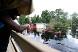
Rescuers, including the police and military, used heavy-lifting equipment to clear roads leading to landslide sites and entered flooded communities using rubber boats.

“The sun is already out, with occasional light rains. We hope floods will subside,” Ronna Monzon, a member of the operations personnel at the disaster agency in Bicol, told Reuters.

About 20 tropical cyclones hit the Philippines every year, with destroyed crops and infrastructure taking a toll on human lives and weighing down one of the fastest growing economies in Asia.

(Reporting by Neil Jerome Morales and Karen Lema; Editing by Paul Tait)

Philippines evacuates coastal areas ahead of typhoon Yutu

A general view of the damage after Super Typhoon Yutu hit Saipan, Northern Mariana Islands, U.S., October 25, 2018 in this picture taken through a cracked vehicle window, obtained from social media. Brad Ruszala via REUTERS

MANILA (Reuters) – The Philippines raised storm warning levels on Monday and began evacuating some coastal communities in the path of a typhoon that threatened storm surges, landslides and floods triggered by heavy winds and rain.

Typhoon Yutu, which caused havoc last week with a direct hit on the U.S. Northern Mariana islands, was set to make landfall on Tuesday morning and move across the main island of Luzon before leaving the Philippines 24 hours later, the state weather agency PAGASA said.

By mid-morning on Monday, Yutu was about 400 km (249 miles)east of the mainland and had weakened to sustained wind speeds of 150 km per hour (93 mph), with gusts of 185 kph, from 170 kph recorded a few hours earlier.

That was less intense than four days ago, when as a super typhoon with wind speeds of over 270 kph barreled through the Marianas, a U.S. Western Pacific archipelago of 52,000 people, tearing off roofs, overturning vehicles and cutting off power and water.

Authorities in Isabela and Cagayan provinces started moving residents in coastal towns to evacuation centers while the mountainous Cordillera region was put on red alert for landslides.

Three provinces in north Luzon were elevated to warning signal 3 on the severity scale of 5, and 28 more put on the earliest warnings of 1 and 2, with strong winds and rains expected later on Monday.

Known locally as Rosita, the typhoon will be the 18th to hit the Philippines this year and comes six weeks after super typhoon Mangkhut tore across Luzon, triggering landslides that killed dozens of people and damaged about $180 million of crops.

School classes were suspended in at least five provinces and fishermen in Luzon and the eastern seaboard advised not to go to sea, with warnings of storm surges of up to three metres in six provinces.

All boat services in the port city of Batangas, about 83 km (52 miles) south of Manila, were suspended on Monday.

About half of the Philippines’ 105 million population live in the Luzon region. The country is hit by an average 20 typhoons each year.

(Reporting by Martin Petty and Karen Lema; editing by Darren Schuettler)

Punishing Hurricane Michael bears down on Florida Panhandle

Hurricane Michael is seen in this National Oceanic and Atmospheric Administrations's Geostationary Operational Environmental Satlellite (NOAA GOES-East satellite) image in the Gulf of Mexico, October 9, 2018. Courtesy NOAA GOES-East/Handout via REUTERS

By Devika Krishna Kumar

TALLAHASSEE, Fla. (Reuters) – Hurricane Michael was still strengthening as it closed in on the Florida Panhandle on Wednesday with the threat of catastrophic surges of sea water and roof-shredding winds, and was expected to be the worst hurricane ever recorded in the region.

Michael caught many by surprise with its rapid intensification as it churned north over the Gulf of Mexico. Shortly after 11 a.m. ET (1500 GMT) it was carrying top winds of 150 miles per hour (241 km per hour), making it a very dangerous Category 4 storm on five-step Saffir-Simpson scale, the National Hurricane Center said.

Authorities told residents along the affected areas of Florida’s northwest coast that they had run out of time to evacuate and should hunker down.

The storm caused major disruption to oil and gas production in the U.S. Gulf of Mexico.

Michael’s core was forecast to make landfall on Wednesday afternoon on Florida’s Panhandle and could drive sea water levels as high as 14 feet (4.3 meters) above normal in some areas, the hurricane center said. The storm could still strengthen further before coming ashore, it said.

As the outer bands arrived, ocean water was already flooding parts of Port St. Joe.

Mayor Bo Patterson said about 2,500 of the town’s 3,500 people were still there, including about 100 in a beachside area who did not follow a mandatory evacuation order. The two bridges leading out of Port St. Joe were closed, meaning no one could get out now.

“People are finally getting it, that this is going to be pretty strong,” Patterson said. “This happened so quickly, we weren’t exactly prepared.”

Michael grew from a tropical storm to Category 4 hurricane in about 40 hours.

“This kind of sprung up for us quite quickly,” said Andrew Gillum, mayor of the state capital, Tallahassee, which lies about 25 miles (40 km) from the coast and was preparing for a battering.

“We honestly felt we might have a tropical system and weren’t sure where it would go and now we’re staring down the barrel of a Category 4 storm,” Gillum told CNN.

“Satellite images of Michael’s evolution on Tuesday night were, in a word, jaw-dropping,” wrote Bob Henson, a meteorologist with weather site Weather Underground.

People in coastal parts of 20 Florida counties had been told to leave their homes. Much of the area is rural and known for small tourist cities, beaches and wildlife reserves, as well as Tallahassee.
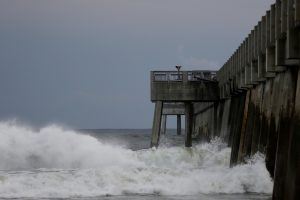
Waves crash along a pier as Hurricane Michael approaches Panama City Beach, Florida, U.S. October 9, 2018. REUTERS/Jonathan Bachman

Waves crash along a pier as Hurricane Michael approaches Panama City Beach, Florida, U.S. October 9, 2018. REUTERS/Jonathan Bachman

TOO LATE TO LEAVE

Governor Rick Scott said on Twitter on Wednesday morning that it was too late to evacuate the target zone and that people who had stayed should immediately seek refuge.

Hurricane center Director Ken Graham said on Facebook that Michael would be the worst storm in recorded history to hit the Panhandle.

“Going back through records to 1851 we can’t find another Cat 4 in this area, so this is unfortunately a historical and incredibly dangerous and life-threatening situation,” he said.

Nearly 40 percent of daily crude oil production and more than one-third of natural gas output was lost from offshore U.S. Gulf of Mexico wells on Wednesday because of platform evacuations and shut-ins caused by Michael.

The hurricane was about 60 miles (95 km) south-southwest of Panama City, Florida, and moving north-northeast at 14 mph (22 kph), the hurricane center said in its 11 a.m. ET advisory.

Apalachicola Mayor Van Johnson said his city, which could suffer some of the worst of the storm surge, was under mandatory evacuation orders.

“My greatest concern is that some people are just now starting to take this storm seriously and are evacuating,” he told CNN. “And I just hope the others that have not made that decision get out while the roads are still passable and before the bridges close.”

President Donald Trump declared a state of emergency for the entire state of Florida, freeing up federal assistance to supplement state and local disaster responses.

POWER CUTS START

Authorities warned of coming disruptions for those in Michael’s path. About 10,000 customers were already without power around midday.

The region should brace for “major infrastructure damage,” specifically to electricity distribution, wastewater treatment systems and transportation networks, Jeff Byard, associate administrator for the Federal Emergency Management Agency, told reporters on a conference call.

Many state offices, schools and universities in the area have been closed since Tuesday.

Helen Neal, 88, and her husband, J.W. Neal, 87, preferred to take their chances in a hotel rather than in their two-story beachfront house about a mile away in Panama City.

“We just finished renovating and updating,” she said. “We’re kind of nervous. God willing we’ll still have some place.”

About 2,500 National Guard troops were deployed to assist with evacuations and storm preparations, and more than 4,000 others were on standby. Some 17,000 utility restoration workers were also on call.

NHC Director Graham said Michael represented a “textbook case” of a hurricane system growing stronger as it drew near shore, in contrast to Hurricane Florence, which struck North Carolina last month after weakening in a slow, halting approach.

He said the storm would still have hurricane-force winds as it pushed through Florida into Georgia and tropical storm-force winds when it reaches the Carolinas, which are still reeling from post-Florence flooding. Up to a foot (30 cm) of rainfall was forecast for some areas.

Scott, a Republican running for the U.S. Senate in November’s congressional elections, declared a state of emergency in 35 Florida counties.

Georgia Governor Nathan Deal declared a state of emergency on Tuesday for 92 counties in his state and a state of emergency also was announced in North Carolina.

The last major hurricane, a storm of Category 3 or above, to hit the Panhandle was Dennis in 2005, according to hurricane center data.

(Reporting by Devika Krishna Kumar in Tallahassee, Florida; additional reporting by Rod Nickel in Panama City, Florida, Susan Heavey and Roberta Rampton in Washington, Gina Cherelus and Barbara Goldberg in New York, Brendan O’Brien in Milwaukee, Liz Hampton in Houston, Andrew Hay in New Mexico; Writing by Lisa Shumaker and Bill Trott; Editing by Frances Kerry)


North Carolina town may never fully recover from double whammy of storms

Katrina Bullock, who is still in the process of rebuilding after floods from Hurricane Matthew in 2016, stacks debris in front of her home after flooding due to Hurricane Florence receded in Fair Bluff, North Carolina, U.S. September 29, 2018. REUTERS/Randall Hill

By Randall Hill

FAIR BLUFF, N.C. (Reuters) – The childhood home Katrina Bullock returned to in the rural North Carolina community of Fair Bluff about 16 years ago to care for her sick mother was devastated by flooding from Hurricane Matthew in 2016.

A new roof went up after that. Walls saturated with muddy floodwaters were being replaced and things were looking up until a new storm, Hurricane Florence struck about 23 months later in September.

Katrina Bullock, who is still in the process of rebuilding after floods from Hurricane Matthew in 2016, cleans the inside of her home after flooding due to Hurricane Florence receded in Fair Bluff, North Carolina, U.S. September 29, 2018. REUTERS/Randall Hill

Katrina Bullock, who is still in the process of rebuilding after floods from Hurricane Matthew in 2016, cleans the inside of her home after flooding due to Hurricane Florence receded in Fair Bluff, North Carolina, U.S. September 29, 2018. REUTERS/Randall Hill

“We were starting to get it all back together and there comes Florence, and it takes it all again,” said Bullock.

She and other residents of Fair Bluff, and of many other communities in the southern and southeast parts of North Carolina hit by the double whammy of Matthew and Florence, are sorting through the latest wreckage, wondering if it is worth remaining.

Settlers first arrived in the area around Fair Bluff in the mid-1700s and one of the oldest buildings in Columbus County, where the town is located, is a trading post built on the banks of the Lumber River in the town, according to the local chamber of commerce. In the 19th century, railroads helped keep the economy

flowing.

Experts say such hamlets and towns face permanent changes, with fewer residents, fewer businesses and fewer prospects of returning to the way things were just a generation ago. Older residents whose roots run deep and those too poor to leave will soon likely make up the bulk of the population.

Those who can will leave, but others will do their best to rebuild.

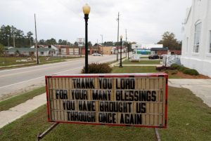
A sign in front of the Fair Bluff United Methodist Church gives a message to the community after flooding due to Hurricane Florence receded in Fair Bluff, North Carolina, U.S. September 29, 2018. REUTERS/Randall Hill

A sign in front of the Fair Bluff United Methodist Church gives a message to the community after flooding due to Hurricane Florence receded in Fair Bluff, North Carolina, U.S. September 29, 2018. REUTERS/Randall Hill

“There will be a real desire to make Fair Bluff the best it can be, but it may look and be a different thing from what it has historically been,” said Patrick Woodie, president of the NC Rural Center, an economic development organization.

Even before Florence hit, many small towns in North Carolina were struggling due to a decline in agriculture and manufacturing. Poverty rates in the state are higher now than in the aftermath of the recession about a decade ago due to the loss of small industries such as textile and a downturn in the farming sector, according to the North Carolina Justice Center, a progressive research and advocacy organization.

Matthew led to catastrophic flooding throughout low-lying eastern North Carolina and caused billions of dollars in damage. In took 28 lives in the United States while Florence killed more than 50 and drove many rural communities into deeper despair.

Fair Bluff is a mostly agricultural community with a Main Street book-ended by two churches and nestled next to the Lumber River, a usually peaceful waterway that flooded during both Matthew and Florence.

The town’s small commercial area was struggling to get back into business after Matthew and inundated again with Florence. Many wonder if it will ever open again.

Randy Britt take a break as he works to clean one of his downtown buildings after flooding due to Hurricane Florence receded in Fair Bluff, North Carolina, U.S. September 29, 2018. REUTERS/Randall Hill

Randy Britt take a break as he works to clean one of his downtown buildings after flooding due to Hurricane Florence receded in Fair Bluff, North Carolina, U.S. September 29, 2018. REUTERS/Randall Hill

Almost all the stores on Main Street closed after Matthew and when Florence rolled in, the floodwaters brought fresh destruction to places like a furniture shop that had yet to remove all of its water-logged inventory from two years ago.

After the flooding from Florence receded, a dark muck covered floors in affected areas and a smell wafted through the air combining odors of moldy rot and a sewage plant that overflowed in the most recent storm.

Fair Bluff Mayor Billy Hammond believes the town had about 1,000 residents before Matthew and was left with about half that afterward, with many evacuees just never returning.

The permanent population now is probably about 350 to 400, most of them are people whose homes were not flooded, he said.

“It has been a ghost town for about two years,” he said in an interview. “We’re just going have to take it one day at a time and move forward and hope that people come back,” he said.

Fair Bluff is about 125 miles (200 km) south of Raleigh. About 21 percent of the population lives below the poverty line and median household income is $28,611, according to U.S. Census data. In Mecklenburg County, North Carolina, home to the vibrant city of Charlotte, median household income is more than double that in Fair Bluff and the poverty rate is about half.

In low-lying areas near the river where some of the poorest people in Fair Bluff live, many have returned to storm-damaged homes because they do not have the money to move or rebuild.A disproportionate number of low-income people live in floodplains in river communities, according to Gavin Smith, a professor in the Department of City and Regional Planning at the University of North Carolina at Chapel Hill.

Randy Britt, 71, who has lived in Fair Bluff all his life

owns buildings on the Main Street commercial area and is working to re-open a flood-hit store.

“There is always hope. If there wasn’t hope, I wouldn’t be in Fair Bluff right now,” he said in an interview.

(Additional reporting by Dan Whitcomb in Los Angeles and Jon Herskovitz in Austin, Texas; Writing by Jon Herskovitz; Editing by Frank McGurty and Tom Brown)

Tropical Storm Rosa will still pack a punch to southern California, Arizona

Hurricane Rosa is shown from a National Oceanic and Atmospheric (NOAA) GOES East satelite over the eastern Pacific Ocean on September 27, 2018, in this image provided September 28, 2018. Image taken September 27, 2018. NOAA/Handout via REUTERS

(Reuters) – Tropical Storm Rosa diminished from a Pacific hurricane over the weekend, but will still bring strong winds and dangerous rip currents to Southern California on Monday, the National Hurricane Center (NHC) said.

It could also bring life-threatening flash floods to central Arizona over the next few days, the NHC added.

“This storm still has a punch, it’s still dangerous,” said David Roth, a meteorologist with the National Weather Service’s Weather Prediction Center in College Park, Maryland.

Swells generated by Rosa on Monday are affecting the coasts of southwestern Mexico, the west coast of the Baja California peninsula and southern California through Tuesday, the weather service said in an advisory.

“We’re already getting rains in southern California through southwest Arizona,” Roth said.

Baja California and southern California could receive 3 to 6 inches of rain, with isolated spots of 10 inches in the next few days. The desert southwest of Arizona could get up to 4 inches of rain, potentially bringing flash floods and mud slides, Roth said.

Rosa was packing 50 mph (85 kmh) winds and was about 140 miles (225 km) west southwest of Punta Eugenia, Mexico at 2 a.m. Monday, Pacific time, the NHC said.

It is expected to diminish in strength as it makes landfall on Monday night and its remnants are expected to move across the southwestern desert on Tuesday.

(Reporting by Rich McKay; Editing by Gaerth Jones)

South Carolina city hopeful as flooding remains a threat

Santee Cooper worker Carl McCrea checks the water levels around a 6000 foot long Aqua Dam built to keep sediment from a coal ash retention pond from going into the flooded Waccamaw River in the aftermath of Hurricane Florence in Conway, South Carolina, U.S. September 26, 2018. REUTERS/Randall Hill

By Harriet McLeod and Gene Cherry

CHARLESTON, S.C./RALEIGH, N.C. (Reuters) – Emergency management officials in Georgetown, South Carolina, were optimistic on Thursday that their port community would see less flooding than previously expected in the aftermath of Hurricane Florence.

Florence, which crashed ashore two weeks ago as a Category 1 hurricane and killed 46 people in three states, has since dissipated, but the storm’s torrential rainfall threatens to swamp Georgetown as it drains toward the ocean.

Forecasts now show floodwaters rising two to four feet (0.6 to 1.2 meters) in Georgetown, which sits at the confluence of the Waccamaw, Great Pee Dee and Sampit rivers about 30 miles (50 km) south of Myrtle Beach, considerably lower than initially feared.

“While we’re optimistic that things are looking better to some degree … there will be increased levels of water in some areas,” Georgetown County Administrator Sel Hemingway said on Wednesday. “The awareness level needs to be elevated.”

Officials were still urging 6,000 to 8,000 residents to leave their homes, with rivers expected to crest in Georgetown on Friday and remain above flood stage for four or five days.

The North Carolina Institute for Climate Studies said preliminary research suggests that Florence was among the rainiest storms in the United States in some 70 years.

South Carolina Governor Henry McMaster said the river flooding caused by Florence, which dropped nearly 20 inches (50 cm) of rain in some places in the state, is something his state has not had to cope with before.

‘FULL BATTLE MODE’

“This is unprecedented and we are still in full battle mode,” McMaster said at a press briefing on Wednesday at Emergency Management Division headquarters in Columbia, the state capital.

Flooding has destroyed 46 homes in the state, significantly damaged more than 1,000 and forced 11,000 people to flee their homes, including 3,000 in Georgetown, EMD Director Kim Stenson said Wednesday.

In Conway County, where the Waccamaw was already well above flood stage, Santee Cooper, South Carolina’s state-owned electric and water utility, said floodwaters stopped rising before inundating a pond that holds more than 200,000 tons of toxic coal ash.

“The river’s rise has slowed and we think it’s cresting today,” utility spokeswoman Mollie Gore said from the site, where 115 workers had shored up the dam around the pond. “We still have a foot between the top of the river and the top of the dam.”

Santee Cooper said it has removed more than 1 million tons of coal ash, which can contaminate water and harm fish and wildlife, from the site in the past few years.

Some one to two inches of rain moving into the central and western parts of the state in a next day or two will prolong the flooding, said meteorologist Rich Otto of the National Weather Service’s Weather Prediction Center in College Park, Maryland.

Crews worked to erect temporary dams on either side of U.S. Highway 17, the main coastal route through the area, and National Guard engineers were installing a floating bridge at Georgetown in case the highway is washed out at the river.

(Reporting by Harriet McLeod and Gene Cherry; additional reporting by Peter Szekely in New York, Makini Brice in Washington, Bernie Woodall in Fort Lauderdale, Florida and Dan Whitcomb in Los Angeles; writing by Peter Szekely and Dan Whitcomb; editing by Cynthia Osterman, Lisa Shumaker, Larry King)

Florence-triggered flooding washes into South Carolina

U.S. Army Pfc. Marlen Squire, of the South Carolina National Guard, assists in evacuating local residents from floodwaters as a result of Hurricane Florence in Dongola, South Carolina, U.S. September 24, 2018. Staff Sgt. Jorge Intriago/U.S. Army National Guard/Handout via REUTERS

By Harriet McLeod and Gene Cherry

CHARLESTON, S.C./RALEIGH, N.C. (Reuters) – Thousands of people in the Georgetown, South Carolina area were urged to leave as rivers inundated by Hurricane Florence rainwater threatened on Wednesday to submerge neighborhoods under 10 feet of water.

Georgetown, which sits at the confluence of the Waccamaw, Great Pee Dee and Sampit rivers, was largely spared the initial fury of Florence, which came ashore on Sept. 14 as a Category 1 hurricane and killed 46 people in three states.

But the port city of more than 9,000 people stands in the path of what the National Weather Service says could be significant flooding as water dumped by the storm system drains to the ocean.

Between 6,000 and 8,000 people have been exhorted to leave, but it was not clear how many had done so as of Tuesday evening, said Randy Akers, deputy public information officer for Georgetown County.

Parts of Georgetown could be submerged in up to 10 feet (3 meters) of water in the coming days as the Pee Dee and Waccamaw rivers overrun their banks, the National Weather Service said, adding that the deluge threatened to cut off highways and isolate communities.

“Be very vigilant,” Georgetown County Emergency Management Director Sam Hodge told residents on Facebook. “When you see the water start to rise, that is when it is time to take action.”

High waters surround homes and businesses in the small town of Bucksport, South Carolina, U.S. as rivers continue to rise and flooded areas expand as a result of Hurricane Florence, September 24, 2018. Staff Sgt. Jorge Intriago/U.S. Army National Guard/Handout via REUTERS

High waters surround homes and businesses in the small town of Bucksport, South Carolina, U.S. as rivers continue to rise and flooded areas expand as a result of Hurricane Florence, September 24, 2018. Staff Sgt. Jorge Intriago/U.S. Army National Guard/Handout via REUTERS

COAL ASH POND COULD FLOOD

In neighboring Conway County, the Waccamaw, which was already well above flood stage on Tuesday, could inundate a coal ash pond that holds more than 200,000 tons of toxic ash, according to Santee Cooper, South Carolina’s state-owned electric and water utility.

Santee Cooper said it has removed more than 1 million tons of coal ash, which can contaminate water and harm fish and wildlife, from the site in the past few years.

The Waccamaw was forecast to crest on Thursday at 22 feet in Conway and at 21.2 feet in Georgetown, a representative with the South Carolina Emergency Management Division said.

The potential flood zone encompasses roughly 3,500 homes in Georgetown, 37 miles (60 km) south of Myrtle Beach, and the coastal resort community of Pawleys Island where as many as 8,000 people live, Georgetown County spokeswoman Jackie Broach-Akers said.

Authorities warned residents in harm’s way with recorded telephone messages and home visits. The county opened two emergency shelters on Monday, and hotels in nearby Myrtle Beach were offering discounts to evacuees. Public schools were closed until further notice.

FILE PHOTO: Water from the flooded Waccamaw River surrounds a house in the aftermath of Hurricane Florence now downgraded to a tropical depression in Conway, South Carolina, U.S. September 19, 2018. REUTERS/Randall

FILE PHOTO: Water from the flooded Waccamaw River surrounds a house in the aftermath of Hurricane Florence now downgraded to a tropical depression in Conway, South Carolina, U.S. September 19, 2018. REUTERS/Randall Hill

Crews worked to erect temporary dams on either side of U.S. Highway 17, the main coastal route through the area, and National Guard engineers were installing a floating bridge at Georgetown in case the highway is washed out at the river.

Florence dumped 30 to 40 inches (75 to 100 cm) of rain on Wilmington, North Carolina, alone.

Insured losses from Hurricane Florence will range from $2.8 billion to $5 billion, according to RMS, a risk modeling and analytics firm.

(Additional reporting by Brendan O’Brien in Milwaukee and Dan Whitcomb in Los Angeles; Writing by Dan Whitcomb; Editing by Bill Trott, Leslie Adler and Cynthia Osterman)

Waterways rise in South Carolina, residents told to leave

Flooding is seen in and around Wilmington, North Carolina, U.S., September 19, 2018 in this picture obtained from social media on September 21, 2018. ALAN CRADICK, CAPE FEAR RIVER WATCH/via REUTERS

By Harriet McLeod and Gene Cherry

CHARLESTON, S.C./RALEIGH, N.C. (Reuters) – Authorities urged thousands of people to leave their homes around the city of Georgetown, South Carolina as water dumped by long-departed Hurricane Florence surged down rivers and threatened to bring devastating floods.

Water levels were still rising early on Tuesday, said emergency services there, more than a week after the storm first made landfall on the U.S. Atlantic coast and killed 46 people mostly in North Carolina.

Parts of Georgetown could be submerged in up to 10 feet (3 meters) of floodwaters in the next few days as the Pee Dee and Waccamaw rivers overran their banks, said the National Weather Service.

The deluge threatened to cut off highways and isolate communities, they added.

“If the flood map … shows you are in an affected area, you need to leave,” Georgetown County Sheriff Lane Cribb said on Monday. “Your property can be replaced, but your life can’t.”

Authorities were sending recorded telephone messages to residents in harm’s way and will go door-to-door over the next two days, Georgetown County spokeswoman Jackie Broach-Akers said.

The potential flood zone encompasses some 3,500 homes in Georgetown, 37 miles (60 km) south of Myrtle Beach, and the coastal resort community of Pawleys Island where as many as 8,000 people live, Broach-Akers said.

FLORENCE IMPACT “STILL WITH US”

The county opened two emergency shelters on Monday, and hotels outside the flood zone in nearby Myrtle Beach were offering discounts to evacuees. Public schools will be closed until further notice, Broach-Akers said.

State transportation crews were working to erect temporary dams on either side of U.S. Highway 17, the main coastal route through the area, and National Guard engineers were installing a floating bridge at Georgetown in case the highway is washed out at the river.

The National Weather Service said flooding from Florence would likely persist in coastal parts of the Carolinas for days as the high-water crest of numerous rivers keeps moving downstream toward the ocean.

In North Carolina, Governor Roy Cooper said on Monday that seven rivers in the southeast part of the state were at major flood stages and three others at moderate flood stages.

“Florence is gone but the storm’s devastation is still with us,” Cooper said in a statement.

The storm dumped 30 to 40 inches (75 to 100 cm) of rain on Wilmington, North Carolina, alone after making landfall nearby on Sept. 14. The storm moved northwest before turning back east and becoming a post-tropical cyclone over West Virginia three days later.

Insured losses from Hurricane Florence will range from $2.8 billion to $5 billion, RMS, a risk modeling and analytics firm, said on Monday.

(Reporting by Brendan O’Brien in Milwaukee; Editing by Andrew Heavens)

Flooding on the horizon for South Carolina, a week after Florence

A closeup of flooded homes and roads near the River Landing Country Club, in the aftermath of Hurricane Florence, is seen in this satellite image over the area in Wallace, North Carolina, U.S., September 20, 2018. Satellite image ©2018 DigitalGlobe, a Maxar company/Handout via REUTERS

By Anna Mehler Paperny

KINSTON, N.C. (Reuters) – Residents in Georgetown County, South Carolina, where five rivers flow into the ocean, will prepare on Friday for a deluge of water in the aftermath of Hurricane Florence, which has killed more than 40 people.

Lying on Atlantic Ocean between Myrtle Beach and Charleston, the county of about 60,000 people is one of several areas across the Carolinas waiting anxiously for rivers to crest, a week after Florence dumped some three feet of rain in the region.

Flooding could begin early next week, officials said during a community meeting on Thursday. The city of Georgetown on Friday will hand out 15,000 sandbags as the county develops plans to evacuate residents.

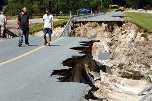
Local residents walk along the edge of a collapsed road that ran atop Patricia Lake's dam after it collapsed in the aftermath of Hurricane Florence, in Boiling Spring Lakes, North Carolina, U.S., September 19, 2018. REUTERS/Jonathan Drake

Local residents walk along the edge of a collapsed road that ran atop Patricia Lake’s dam after it collapsed in the aftermath of Hurricane Florence, in Boiling Spring Lakes, North Carolina, U.S., September 19, 2018. REUTERS/Jonathan Drake

“Please heed the warnings,” Sheriff Lane Cribb said. “Protecting lives and property will be our goal … You better pray. I think we all need to pray that it don’t happen.”

More than three dozen flood gauges in North and South Carolina showed flooding. Some rivers had still not crested by Friday morning, according to the National Weather Service.

Thirty-one deaths have been attributed to the storm in North Carolina, eight in South Carolina and one in Virginia.

Michael Ziolkowski, a Field Operations Supervisor for the National Disaster Response K-9 Unit and his partner, Morty, are transported to support relief efforts in the aftermath of Hurricane Florence in Spring Lake, North Carolina, September 16, 2018. Spc. Austin T. Boucher/U.S. Army/Handout via REUTERS

Michael Ziolkowski, a Field Operations Supervisor for the National Disaster Response K-9 Unit and his partner, Morty, are transported to support relief efforts in the aftermath of Hurricane Florence in Spring Lake, North Carolina, September 16, 2018. Spc. Austin T. Boucher/U.S. Army/Handout via REUTERS

Some 4,700 people across North Carolina have been rescued by boat or helicopter since the storm made landfall, twice as many as in Hurricane Matthew two years ago, according to state officials. About 10,000 remain in shelters.

The coastal city of Wilmington, North Carolina, remained cut off by floodwaters on Thursday. More than 200 roads across the state were closed or blocked as residents. Over 60,000 customers were without power in North Carolina early on Friday, according to Poweroutage.us.

As floodwaters continue to rise, concerns are growing about the environmental and health dangers lurking in the water.

The flooding has caused 21 hog “lagoons,” which store manure from pig farms, to overflow in North Carolina, creating a risk that standing water will be contaminated, according to the state’s Department of Environmental Quality. North Carolina is one of the leading hog-producing states in the country.

Several sewer systems in the region also have released untreated or partly treated sewage and storm water into waterways over the last week, local media reported.

(Reporting by Anna Mehler Paperny in Kinston, North Carolina; Additional reporting by Jeff Mason in Conway, South Carolina, Brendan O’Brien in Milwaukee, Scott DiSavino in New York and Dan Whitcomb in Los Angeles; writing by Dan Whitcomb; editing by Larry King)

Hurricane raises questions about rebuilding along North Carolina’s coast

People work in the reconstruction of Rodanthe pier after being partially damaged after the pass of Hurricane Florence, now downgraded to a tropical depression in Rodanthe, North Carolina, U.S., September 18, 2018. REUTERS/Eduardo Munoz

By Anna Mehler Paperny

RODANTHE, N.C. (Reuters) – When Florence was raging last Friday on North Carolina’s Outer Banks, the hurricane tore a 40-foot (12-meter) chunk from a fishing pier that juts into the ocean at the state’s most popular tourist destination.

The privately owned Rodanthe pier has already undergone half a million dollars in renovation in seven years and the owners started a new round of repairs this week.

“The maintenance and upkeep on a wooden fishing pier is tremendous,” said co-owner Terry Plumblee. “We get the brunt of the rough water here.”

Scientists have warned such rebuilding efforts are futile as sea levels rise and storms chew away the coastline but protests from developers and the tourism industry have led North Carolina to pass laws that disregard the predictions.

The Outer Banks, a string of narrow barrier islands where Rodanthe is situated, may have been spared the worst of Florence, which flooded roads, smashed homes and killed at least 36 people across the eastern seaboard.

Still, the storm showed North Carolinians on this long spindly finger of land that ignoring the forces of nature to cling to their homes and the coast’s $2.4 billion economy may not be sustainable.

Some have called for halting oceanside development altogether.

“We need to actually begin an organized retreat from the rising seas,” said Duke University geologist Orrin Pilkey.

In a government study published in 2010, scientists warned that sea levels could rise 39 inches by 2100

Higher sea level will cause more flooding and render some communities uninhabitable, as well as affect the ocean vegetation, jeopardize the dune systems that help stabilize the barrier islands, and cause more intense erosion when storms like Florence make landfall, scientists said.

Developers said the study was too theoretical to dictate policy.

Some argue policymakers do not need a 90-year projection to know something needs to change.

“When we have a hurricane, that shows everybody where their vulnerabilities are today, forget 100 years from now, but right now,” said Rob Young, a geologist at Western Carolina University who co-authored the study by the state’s Coastal Resources Commission (CRC).

Young said he would like to see development move back from the ocean’s edge and laments that homeowners and developers rebuild almost any structure damaged or destroyed by a bad storm.

But the idea of retreating is a tough sell for the people who live there and have invested in property.

“You’re asking us to say, ‘Hey, 4,000 or 5,000 people on little Hatteras Island, it’s time for you to pack up and move,’ and that’s not a reasonable expectation,” said Bobby Outten, manager for Dare County on the Outer Banks.

Opponents of using the CRC study to set policy said that most Outer Bank homeowners recognize the risks.

“If you’re buying on the coast, anyone that buys in an area surrounded by water, you’re always taking a risk that you’re going to have storm damage,” said Willo Kelly, who has worked in real estate for more than a decade.

Even though she acknowledges that sea levels are rising, Kelly is also among those who opposed making state policy decisions, including anything affecting home insurance or property values, based on the study’s dire 90-year forecast of sea-level rise.

Kelly supported a 2012 state law that banned North Carolina from using the 90-year prediction on rising sea levels to influence coastal development policy.

The CRC released a second report in 2015 predicting sea level rise over a 30-year period, instead of 90 years. The new report was praised by developers as being more realistic and said sea levels would rise 1.9 to 10.6 inches. (https://bit.ly/2xyGDVr)

The 2012 law was welcomed by the development community and panned by scientists whose warnings, they felt, were going unheeded. Members of the legislature who sponsored the bill did not return requests for comment.

After this year’s storm demolished the sandy protective berms that stand between the water and the main coastal road, the state sent backhoes to rebuild them and officials to assess damage to bridges and roads.

“There’s also a sense of denial,” said Gavin Smith, director of the University of North Carolina’s Coastal Resilience Center, adding that with rising seas and more intense storms it will be more costly and more difficult to replace infrastructure.

Rodanthe Pier was lucky this time, sustaining only moderate damage, said Clive Thompson, 58, who works at the pier. In the past, nor’easters have ripped its end from the ground and tore pilings from sand.

The beach was not so lucky. The ocean ate away about 50 meters of what used to be dry sand above the high-tide line, he said.

“It’s a waste of man-hours, time and money, having to do this over and over,” he said. “One day I hope people understand the power of water. … It don’t play.”

(Reporting by Anna Mehler Paperny; Additional reporting by Gabriella Borter in New York; Editing by Frank McGurty and Lisa Shumaker)